Written and fact-checked by Whereig.com Web Team | Last Updated: December 16, 2025, 14:30 ET
Map of Mariposa County - Mariposa County is a county located in the U.S. state of California. Mariposa County Map showing cities, highways, important places and water bodies. Get Where is Mariposa County located in the map, major cities in Mariposa county, population, areas, and places of interest.
Mariposa County Map, California
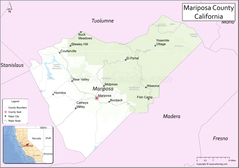
About Mariposa County Map, California: The map showing the county boundary, county seat, major cities, highways, water bodies and neighbouring counties.
Most Viewed Links
About Mariposa County, California
Mariposa County is a county located in the central region of California, United States. The county seat is the town of Mariposa, and the county is named after Mariposa Creek, which flows through it.
Mariposa County covers an area of 1,463 square miles (3,788 square kilometers) and has a population of around 18,000 people as of the 2020 census. The county is home to the western portion of Yosemite National Park, including the Yosemite Valley, which attracts millions of visitors each year.
Apart from Yosemite, other popular attractions in Mariposa County include the Mariposa Museum and History Center, the California State Mining and Mineral Museum, and the Mariposa Butterfly Festival. The county is also known for its outdoor recreation opportunities, including hiking, fishing, camping, and skiing.
Facts about Mariposa County, California
| Country | United States |
| State | California |
| Region | Central California (Sierra Nevada foothills) |
| County Seat | Mariposa |
| Named After | Spanish word “Mariposa,” meaning “butterfly” |
| Established | 1850 |
| Organized | 1850 |
| Coordinates | 37.5816° N, 119.9050° W |
| Total Area | 1,463 sq mi |
| Land Area | 1,449 sq mi |
| Water Area | 14 sq mi |
| Population (2020) | 17,131 |
| Population Rank | One of the least populous counties in California |
| Major Community | Mariposa |
| Main Industries | Tourism, Government Services, Outdoor Recreation |
| Major Airport | Mariposa-Yosemite Airport |
| Time Zone | Pacific Time (UTC−08:00) |
| Known For | Yosemite National Park (part), Gold Rush history, Scenic foothills and mountains |
| Website | https://www.mariposacounty.org |