Written and fact-checked by Whereig.com Web Team | Last Updated: December 16, 2025, 14:30 ET
Map of Trinity County - Trinity County is a county located in the U.S. state of California. Trinity County Map showing cities, highways, important places and water bodies. Get Where is Trinity County located in the map, major cities in Trinity county, population, areas, and places of interest.
Trinity County Map, California
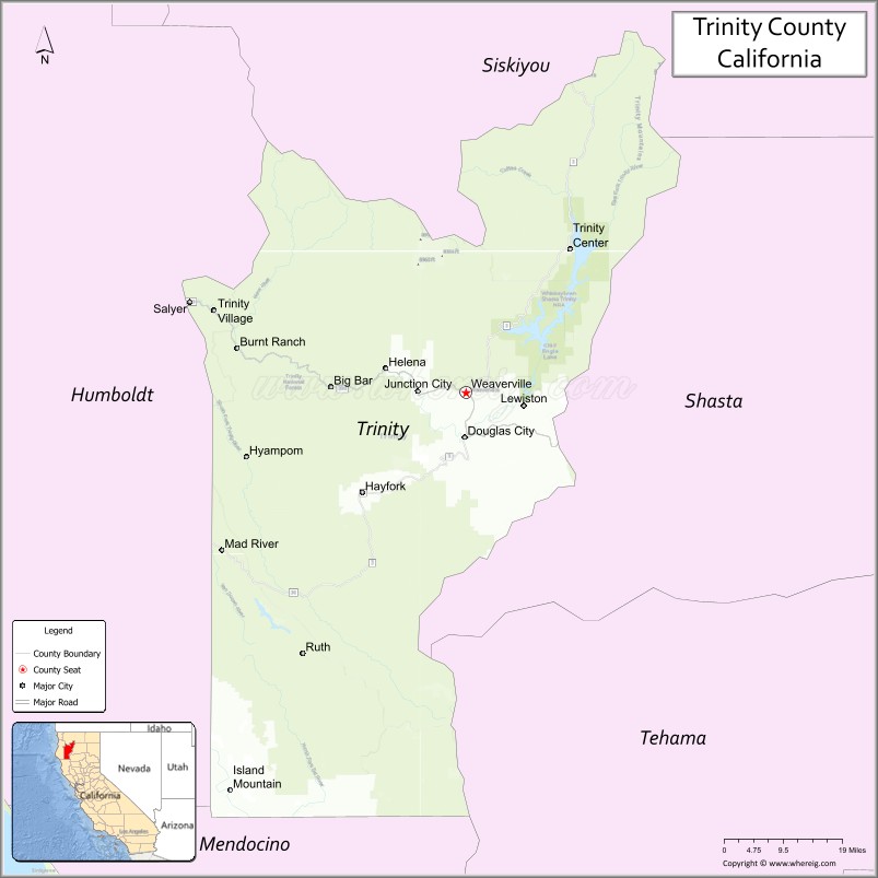
About Trinity County Map, California: The map showing the county boundary, county seat, major cities, highways, water bodies and neighbouring counties.
Most Viewed Links
About Trinity County, California
Trinity County is a county located in the northern part of the state of California, United States. The county seat and largest city is Weaverville. According to the United States Census Bureau, the county has a total area of 3,208 square miles (8,311 km²), of which 3,179 square miles (8,226 km²) is land and 29 square miles (75 km²) (0.9%) is water. As per 2020 census, the population of Trinity County is 16060 people and population density is square miles.
As of the 2020 United States Census, the population of Trinity County was 12,319. The county is known for its natural beauty, including Trinity Alps Wilderness, a popular destination for hiking and backpacking. The area is also known for its rich history of mining and logging.
Major cities and towns in Trinity County include Weaverville, Hayfork, and Lewiston. The county is bordered by Siskiyou County to the north, Shasta County to the east, Tehama County to the south, and Mendocino County and Humboldt County to the west.
Facts about Trinity County, California
| Country | United States |
| State | California |
| Region | Northern California (Trinity Alps & Klamath Mountains) |
| County Seat | Weaverville |
| Named After | Trinity River |
| Established | 1850 |
| Organized | 1850 |
| Coordinates | 40.6518° N, 123.1126° W |
| Total Area | 3,208 sq mi |
| Land Area | 3,179 sq mi |
| Water Area | 29 sq mi |
| Population (2020) | 16,060 |
| Population Rank | One of the least populous counties in California |
| Major Communities | Weaverville, Hayfork, Trinity Center |
| Main Industries | Government Services, Forestry, Tourism, Outdoor Recreation |
| Major Airport | None (nearest commercial airports outside the county) |
| Time Zone | Pacific Time (UTC−08:00) |
| Known For | Trinity Alps Wilderness, Trinity River, Gold Rush history, Scenic mountain landscapes |
| Website | https://www.trinitycounty.org |