Written and fact-checked by Whereig.com Web Team | Last Updated: December 16, 2025, 14:30 ET
Map of Imperial County - Imperial County is a county located in the U.S. state of California. Imperial County Map showing cities, highways, important places and water bodies. Get Where is Imperial County located in the map, major cities in Imperial county, population, areas, and places of interest.
Imperial County Map, California
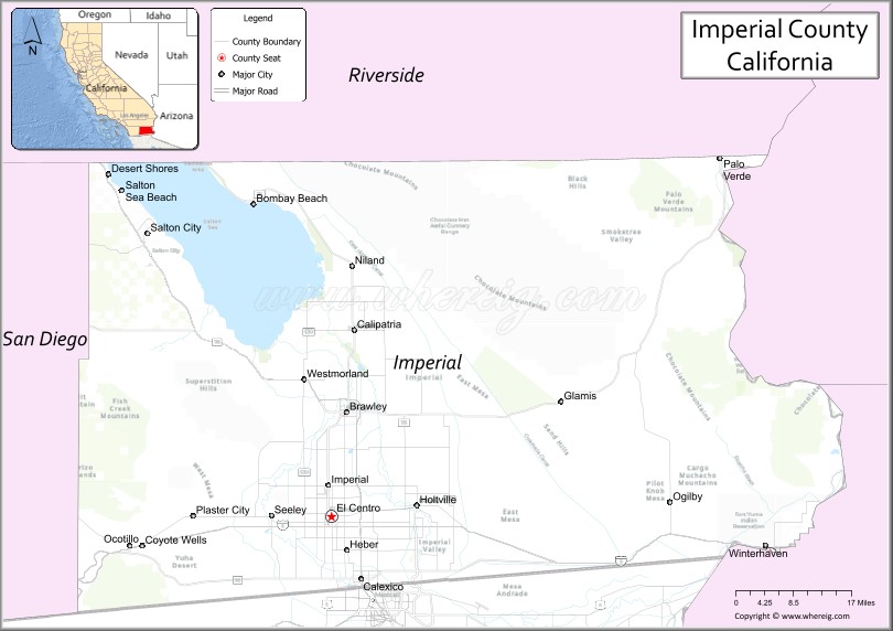
About Imperial County Map, California: The map showing the county boundary, county seat, major cities, highways, water bodies and neighbouring counties.
Most Viewed Links
About Imperial County, California
Imperial County is a county located in the southeastern part of the state of California in the United States. Its county seat is El Centro. The county is located in the Imperial Valley, a fertile agricultural region that straddles the United States-Mexico border.
Imperial County has a population of approximately 180,000 people and covers an area of about 4,482 square miles. The county is known for its agricultural industry, which produces crops such as lettuce, broccoli, melons, and carrots. The Salton Sea, the largest lake in California, is also located in Imperial County.Imperial County was established on 1907.
El Centro is the largest community in Imperial County and serves as the county seat. Other communities in the county include Calexico, Brawley, and Imperial.
Facts about Imperial County, California
| Country | United States |
| State | California |
| Region | Southern California (Imperial Valley) |
| County Seat | El Centro |
| Named After | Imperial Valley |
| Established | 1907 |
| Organized | 1907 |
| Coordinates | 33.0397° N, 115.3653° W |
| Total Area | 4,597 sq mi |
| Land Area | 4,176 sq mi |
| Water Area | 421 sq mi |
| Population (2020) | 181,215 |
| Population Rank | Mid-sized county in California |
| Major Cities | El Centro, Calexico, Brawley, Imperial |
| Main Industries | Agriculture, Renewable Energy, Government Services, Cross-border Trade |
| Major Airport | Imperial County Airport |
| Time Zone | Pacific Time (UTC−08:00) |
| Known For | Imperial Valley agriculture, Salton Sea, Border location with Mexico, Desert climate |
| Website | https://www.co.imperial.ca.us |
Ctities and Towns in Imperial County
| City Name | Type | Population (2020) | Pop. Density | Area | Incorporated |
|---|---|---|---|---|---|
| Brawley | City | 26,416 | 3,253.2/sq mi (1,256.1/km2) | 8.12 sq mi (21 km2) | April 6, 1908 |
| Calexico | City | 38,633 | 4,481.8/sq mi (1,730.4/km2) | 8.62 sq mi (22.3 km2) | April 16, 1908 |
| Calipatria | City | 6,515 | 1,760.8/sq mi (679.9/km2) | 3.7 sq mi (9.6 km2) | February 28, 1919 |
| El Centro | City | 44,322 | 3,743.4/sq mi (1,445.3/km2) | 11.84 sq mi (30.7 km2) | April 16, 1908 |
| Holtville | City | 5,605 | 4,873.9/sq mi (1,881.8/km2) | 1.15 sq mi (3 km2) | July 1, 1908 |
| Imperial | City | 20,263 | 3,221.5/sq mi (1,243.8/km2) | 6.29 sq mi (16.3 km2) | July 12, 1904 |
| Westmorland | City | 2,014 | 3,413.6/sq mi (1,318.0/km2) | 0.59 sq mi (1.5 km2) | June 30, 1934 |
Places to Visit in Imperial County
Top places to visit in Imperial includes East Jesus, Pioneers' Museum, Salton Sea, Sonny Bono Salton Sea, Desert View Tower, Salton Sea, Sonny Bono Salton Sea, Imperial Sand Dunes.
Highways in Imperial County
Interstate 8, State Route 7, State Route 78, State Route 86, State Route 98, State Route 111, State Route 115, State Route 186.
Nearest Airports
Nearest airport of Imperial is Imperial County Airport.
- Alameda County Map
- Alpine County Map
- Amador County Map
- Butte County Map
- Calaveras County Map
- Colusa County Map
- Contra Costa County Map
- Del Norte County Map
- El Dorado County Map
- Fresno County Map
- Glenn County Map
- Humboldt County Map
- Imperial County Map
- Inyo County Map
- Kern County Map
- Kings County Map
- Lake County Map
- Lassen County Map
- Los Angeles County Map
- Madera County Map
- Marin County Map
- Mariposa County Map
- Mendocino County Map
- Merced County Map
- Modoc County Map
- Mono County Map
- Monterey County Map
- Napa County Map
- Nevada County Map
- Orange County Map
- Placer County Map
- Plumas County Map
- Riverside County Map
- Sacramento County Map
- San Benito County Map
- San Bernardino County Map
- San Diego County Map
- San Francisco County Map
- San Joaquin County Map
- San Luis Obispo County Map
- San Mateo County Map
- Santa Barbara County Map
- Santa Clara County Map
- Santa Cruz County Map
- Shasta County Map
- Sierra County Map
- Siskiyou County Map
- Solano County Map
- Sonoma County Map
- Stanislaus County Map
- Sutter County Map
- Tehama County Map
- Trinity County Map
- Tulare County Map
- Tuolumne County Map
- Ventura County Map
- Yolo County Map
- Yuba County Map
- Alabama Counties
- Alaska boroughs
- Arizona Counties
- Arkansas Counties
- California County Map
- Colorado Counties
- Connecticut Counties
- Delaware Counties
- Florida County Map
- Georgia County Map
- Hawaii Counties
- Idaho Counties
- Illinois Counties
- Indiana Counties
- Iowa Counties
- Kansas Counties
- Kentucky Counties
- Louisiana Counties
- Maine Counties
- Maryland Counties
- Massachusetts Counties
- Michigan County Map
- Minnesota Counties
- Mississippi Counties
- Missouri Counties
- Montana Counties
- Nebraska Counties
- Nevada Counties
- New York Counties
- New Hampshire Counties
- New Jersey Counties
- New Mexico Counties
- North Carolina Counties
- North Dakota Counties
- Ohio County Map
- Oklahoma Counties
- Oregon Counties
- Pennsylvania Counties
- Rhode Island Counties
- South Carolina Counties
- South Dakota Counties
- Map of Tennessee
- Texas County Map
- Utah Counties
- Vermont Counties
- Virginia Counties
- Washington Counties
- West Virginia Counties
- Wisconsin Counties
- Wyoming Counties