Written and fact-checked by Whereig.com Web Team | Last Updated: December 16, 2025, 14:30 ET
Map of San Benito County - San Benito County is a county located in the U.S. state of California. San Benito County Map showing cities, highways, important places and water bodies. Get Where is San Benito County located in the map, major cities in San Benito county, population, areas, and places of interest.
San Benito County Map, California
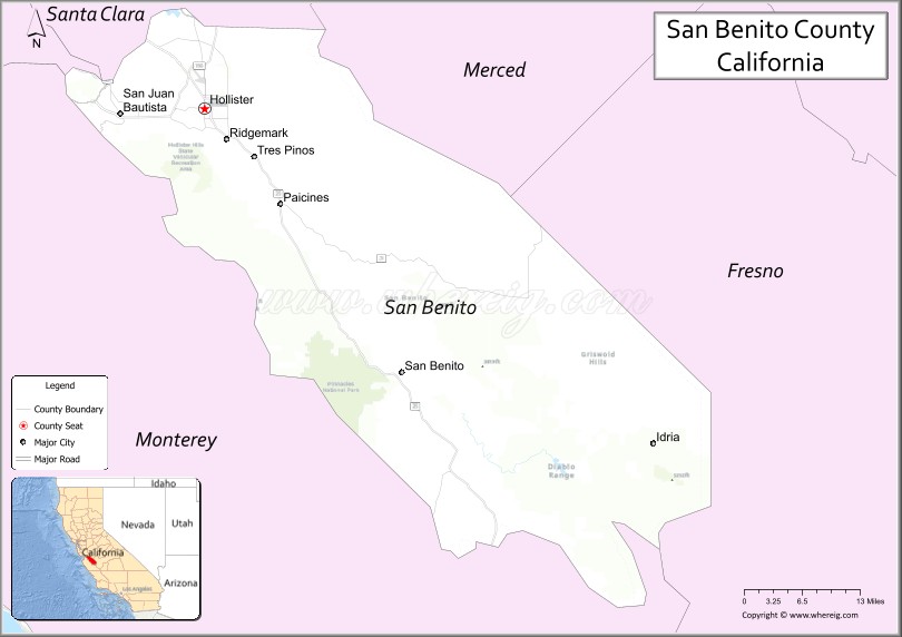
About San Benito County Map, California: The map showing the county boundary, county seat, major cities, highways, water bodies and neighbouring counties.
Most Viewed Links
About San Benito County, California
San Benito County is a county located in central California, with its county seat in the city of Hollister. The county has an estimated population of over 63,000 people as of 2021.According to the United States Census Bureau, the county has a total area of 1,389 sq mi (3,597 km2). San Benito County was established on 1874.
San Benito County is known for its agricultural industry, with crops such as strawberries, lettuce, and wine grapes being major contributors to the local economy. The county is also home to several historic landmarks, including the San Juan Bautista Mission, which was founded in 1797 and is now a National Historic Landmark.
The county is also a popular destination for outdoor recreation, with the Pinnacles National Park located in the eastern part of the county. The park features unique rock formations and offers hiking, rock climbing, and camping opportunities.
Economically, San Benito County is driven by agriculture, as well as healthcare, education, and retail. The county is also home to a number of wineries and vineyards, which contribute to the local economy and tourism industry.
Facts about San Benito County, California
| Country | United States |
| State | California |
| Region | Central Coast & San Joaquin Valley foothills |
| County Seat | Hollister |
| Named After | San Benito River, named for Saint Benedict |
| Established | 1874 |
| Organized | 1874 |
| Coordinates | 36.6056° N, 121.0750° W |
| Total Area | 1,390 sq mi |
| Land Area | 1,389 sq mi |
| Water Area | 1 sq mi |
| Population (2020) | 64,209 |
| Population Rank | One of the least populous counties in California |
| Major City | Hollister |
| Main Industries | Agriculture, Food Processing, Government Services |
| Major Airport | Hollister Municipal Airport |
| Time Zone | Pacific Time (UTC−08:00) |
| Known For | Agricultural production, Hollister Rally history, Pinnacles National Park (part) |
| Website | https://www.cosb.us |
Ctities and Towns in San Benito County
| City Name | Type | Population (2020) | Pop. Density | Area | Incorporated |
|---|---|---|---|---|---|
| Hollister | City | 41,678 | 5,235.9/sq mi (2,021.6/km2) | 7.96 sq mi (20.6 km2) | March 26, 1872 |
| San Juan Bautista | City | 2,089 | 2,644.3/sq mi (1,021.0/km2) | 0.79 sq mi (2 km2) | May 4, 1896 |
Places to Visit in San Benito County
Top places to visit in San Benito includes Pinnacles National Park, Monterey Bay Aquarium, Hollister Hills State Vehicular, Bear Gulch Cave Trail, Fremont Peak State Park, Pinnacles Visitor Center, Leal Vineyards and Winery, Chaparral Trailhead Parking, Prewett Point Trail, San Benito Mountain, Mount Harlan, San Felipe Lake, San Juan Valley, California 1, Dunne Park, Carmel-by-the-Sea, Big Sur, .
Highways in San Benito County
U.S. Route 101, State Route 25, e Route 129 to Santa Cruz, State Route 146, State Route 156.
Nearest Airports
Nearest airport of San Benito is Harlingen (HRL) Airport.
- Alameda County Map
- Alpine County Map
- Amador County Map
- Butte County Map
- Calaveras County Map
- Colusa County Map
- Contra Costa County Map
- Del Norte County Map
- El Dorado County Map
- Fresno County Map
- Glenn County Map
- Humboldt County Map
- Imperial County Map
- Inyo County Map
- Kern County Map
- Kings County Map
- Lake County Map
- Lassen County Map
- Los Angeles County Map
- Madera County Map
- Marin County Map
- Mariposa County Map
- Mendocino County Map
- Merced County Map
- Modoc County Map
- Mono County Map
- Monterey County Map
- Napa County Map
- Nevada County Map
- Orange County Map
- Placer County Map
- Plumas County Map
- Riverside County Map
- Sacramento County Map
- San Benito County Map
- San Bernardino County Map
- San Diego County Map
- San Francisco County Map
- San Joaquin County Map
- San Luis Obispo County Map
- San Mateo County Map
- Santa Barbara County Map
- Santa Clara County Map
- Santa Cruz County Map
- Shasta County Map
- Sierra County Map
- Siskiyou County Map
- Solano County Map
- Sonoma County Map
- Stanislaus County Map
- Sutter County Map
- Tehama County Map
- Trinity County Map
- Tulare County Map
- Tuolumne County Map
- Ventura County Map
- Yolo County Map
- Yuba County Map
- Alabama Counties
- Alaska boroughs
- Arizona Counties
- Arkansas Counties
- California County Map
- Colorado Counties
- Connecticut Counties
- Delaware Counties
- Florida County Map
- Georgia County Map
- Hawaii Counties
- Idaho Counties
- Illinois Counties
- Indiana Counties
- Iowa Counties
- Kansas Counties
- Kentucky Counties
- Louisiana Counties
- Maine Counties
- Maryland Counties
- Massachusetts Counties
- Michigan County Map
- Minnesota Counties
- Mississippi Counties
- Missouri Counties
- Montana Counties
- Nebraska Counties
- Nevada Counties
- New York Counties
- New Hampshire Counties
- New Jersey Counties
- New Mexico Counties
- North Carolina Counties
- North Dakota Counties
- Ohio County Map
- Oklahoma Counties
- Oregon Counties
- Pennsylvania Counties
- Rhode Island Counties
- South Carolina Counties
- South Dakota Counties
- Map of Tennessee
- Texas County Map
- Utah Counties
- Vermont Counties
- Virginia Counties
- Washington Counties
- West Virginia Counties
- Wisconsin Counties
- Wyoming Counties