Written and fact-checked by Whereig.com Web Team | Last Updated: December 16, 2025, 14:30 ET
Map of Sierra County - Sierra County is a county located in the U.S. state of California. Sierra County Map showing cities, highways, important places and water bodies. Get Where is Sierra County located in the map, major cities in Sierra county, population, areas, and places of interest.
Sierra County Map, California
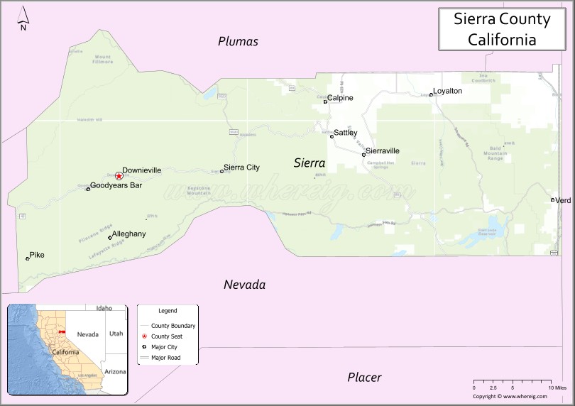
About Sierra County Map, California: The map showing the county boundary, county seat, major cities, highways, water bodies and neighbouring counties.
Most Viewed Links
About Sierra County, California
Sierra County is a county located in the eastern part of the U.S. state of California. It is situated in the Sierra Nevada region and its county seat is Downieville. As of the 2020 census, the population of Sierra County was estimated to be around 2,900 people.According to the United States Census Bureau, the county has a total area of 953 sq mi (2,468 km2). Sierra County was established on 1852.
Sierra County is known for its natural beauty, with many outdoor recreational activities available such as fishing, hiking, camping, and skiing. The county is home to several national forests, including Tahoe National Forest and Plumas National Forest. It also contains several bodies of water, such as the Yuba River and Lakes Basin Recreation Area.
The economy of Sierra County is primarily based on tourism, with many visitors coming to enjoy the county's natural attractions. The county also has some mining and logging operations, although these industries have declined in recent years.
Sierra County has a rich history, including the California Gold Rush and the construction of the Western Pacific Railroad. The county has several historic sites, including the Downieville Museum, the Kentucky Mine Historic Park, and the Sierra City Cemetery.
Facts about Sierra County, California
| Country | United States |
| State | California |
| Region | Northern Sierra Nevada |
| County Seat | Downieville |
| Named After | Sierra Nevada mountain range |
| Established | 1852 |
| Organized | 1852 |
| Coordinates | 39.5765° N, 120.5217° W |
| Total Area | 953 sq mi |
| Land Area | 953 sq mi |
| Water Area | 0 sq mi |
| Population (2020) | 3,240 |
| Population Rank | One of the least populous counties in California |
| Major Communities | Downieville, Loyalton, Sierra City |
| Main Industries | Government Services, Tourism, Forestry, Agriculture |
| Major Airport | None (nearest commercial airports outside the county) |
| Time Zone | Pacific Time (UTC−08:00) |
| Known For | Gold Rush history, Sierra Nevada scenery, Outdoor recreation, Rural mountain communities |
| Website | https://www.sierracounty.ca.gov |
Ctities and Towns in Sierra County
| City Name | Type | Population (2020) | Pop. Density | Area | Incorporated |
|---|---|---|---|---|---|
| Anderson | City | 11,323 | 1,610.7/sq mi (621.9/km2) | 7.03 sq mi (18.2 km2) | January 16, 1956 |
| Redding | City | 93,611 | 1,569.3/sq mi (605.9/km2) | 59.65 sq mi (154.5 km2) | October 4, 1887 |
| Shasta Lake | City | 10,371 | 949.7/sq mi (366.7/km2) | 10.92 sq mi (28.3 km2) | July 2, 1993 |
Places to Visit in Sierra County
Top places to visit in Sierra includes Yosemite National Park, Lassen Volcanic National Park, Sierra Hot Springs, LAKES BASIN, Sierra Buttes Fire Lookout, Lake Tahoe, Webber Falls, Columbia State Historic Park, .
Highways in Sierra County
U.S. Route 395, Interstate 80, State Route 49, State Route 89, County Route A23, County Route A24.
Nearest Airports
Nearest airport of Sierra is Sierraville Dearwater Airport.
- Alameda County Map
- Alpine County Map
- Amador County Map
- Butte County Map
- Calaveras County Map
- Colusa County Map
- Contra Costa County Map
- Del Norte County Map
- El Dorado County Map
- Fresno County Map
- Glenn County Map
- Humboldt County Map
- Imperial County Map
- Inyo County Map
- Kern County Map
- Kings County Map
- Lake County Map
- Lassen County Map
- Los Angeles County Map
- Madera County Map
- Marin County Map
- Mariposa County Map
- Mendocino County Map
- Merced County Map
- Modoc County Map
- Mono County Map
- Monterey County Map
- Napa County Map
- Nevada County Map
- Orange County Map
- Placer County Map
- Plumas County Map
- Riverside County Map
- Sacramento County Map
- San Benito County Map
- San Bernardino County Map
- San Diego County Map
- San Francisco County Map
- San Joaquin County Map
- San Luis Obispo County Map
- San Mateo County Map
- Santa Barbara County Map
- Santa Clara County Map
- Santa Cruz County Map
- Shasta County Map
- Sierra County Map
- Siskiyou County Map
- Solano County Map
- Sonoma County Map
- Stanislaus County Map
- Sutter County Map
- Tehama County Map
- Trinity County Map
- Tulare County Map
- Tuolumne County Map
- Ventura County Map
- Yolo County Map
- Yuba County Map
- Alabama Counties
- Alaska boroughs
- Arizona Counties
- Arkansas Counties
- California County Map
- Colorado Counties
- Connecticut Counties
- Delaware Counties
- Florida County Map
- Georgia County Map
- Hawaii Counties
- Idaho Counties
- Illinois Counties
- Indiana Counties
- Iowa Counties
- Kansas Counties
- Kentucky Counties
- Louisiana Counties
- Maine Counties
- Maryland Counties
- Massachusetts Counties
- Michigan County Map
- Minnesota Counties
- Mississippi Counties
- Missouri Counties
- Montana Counties
- Nebraska Counties
- Nevada Counties
- New York Counties
- New Hampshire Counties
- New Jersey Counties
- New Mexico Counties
- North Carolina Counties
- North Dakota Counties
- Ohio County Map
- Oklahoma Counties
- Oregon Counties
- Pennsylvania Counties
- Rhode Island Counties
- South Carolina Counties
- South Dakota Counties
- Map of Tennessee
- Texas County Map
- Utah Counties
- Vermont Counties
- Virginia Counties
- Washington Counties
- West Virginia Counties
- Wisconsin Counties
- Wyoming Counties