Written and fact-checked by Whereig.com Web Team | Last Updated: December 16, 2025, 14:30 ET
Map of Marin County - Marin County is a county located in the U.S. state of California. Marin County Map showing cities, highways, important places and water bodies. Get Where is Marin County located in the map, major cities in Marin county, population, areas, and places of interest.
Marin County Map, California
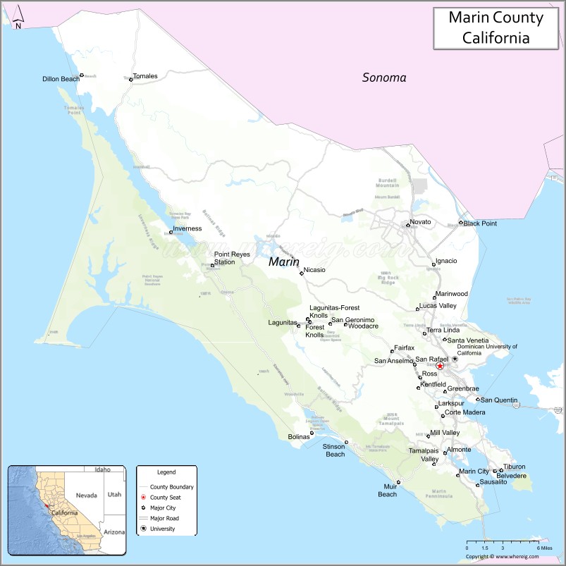
About Marin County Map, California: The map showing the county boundary, county seat, major cities, highways, water bodies and neighbouring counties.
Most Viewed Links
About Marin County, California
Marin County is a county located in the northern part of the state of California in the United States. Its county seat is San Rafael. The county is known for its natural beauty, including the rugged coastline, redwood forests, and picturesque hillsides.
Marin County is a county located in the U.S. state of California. It's county seat is San Rafael. As per 2020 census, the population of Marin County is 260206 people and population density is square miles. According to the United States Census Bureau, the county has a total area of 520 sq mi (1,347 km2). Marin County was established on 1850. The county is known for its high quality of life, strong economy, and vibrant arts and cultural scene. Outdoor recreational activities such as hiking, biking, and water sports are popular in the area.
San Rafael is the largest community in Marin County and serves as the county seat. Other communities in the county include Novato, Mill Valley, and Sausalito.If you have any specific questions about Marin County, feel free to ask and I'll do my best to assist you!
Facts about Marin County, California
| Country | United States |
| State | California |
| Region | San Francisco Bay Area (North Bay) |
| County Seat | San Rafael |
| Named After | Chief Marin (Marinero) |
| Established | 1850 |
| Organized | 1850 |
| Coordinates | 38.0834° N, 122.7633° W |
| Total Area | 828 sq mi |
| Land Area | 520 sq mi |
| Water Area | 308 sq mi |
| Population (2020) | 262,321 |
| Population Rank | Mid-sized county in California |
| Major Cities | San Rafael, Novato, Mill Valley, Sausalito |
| Main Industries | Healthcare, Education, Tourism, Professional Services |
| Major Airport | None (nearest major airports outside the county) |
| Time Zone | Pacific Time (UTC−08:00) |
| Known For | Golden Gate Bridge (part), Marin Headlands, Mount Tamalpais, Coastal scenery |
| Website | https://www.marincounty.org |
Ctities and Towns in Marin County
| City Name | Type | Population (2020) | Pop. Density | Area | Incorporated |
|---|---|---|---|---|---|
| Belvedere | City | 2,126 | 4,088.5/sq mi (1,578.6/km2) | 0.52 sq mi (1.3 km2) | December 24, 1896 |
| Corte Madera | Town | 10,222 | 3,234.8/sq mi (1,249.0/km2) | 3.16 sq mi (8.2 km2) | June 10, 1916 |
| Fairfax | Town | 7,605 | 3,410.3/sq mi (1,316.7/km2) | 2.23 sq mi (5.8 km2) | March 2, 1931 |
| Larkspur | City | 13,064 | 4,354.7/sq mi (1,681.3/km2) | 3 sq mi (7.8 km2) | March 1, 1908 |
| Mill Valley | City | 14,231 | 2,977.2/sq mi (1,149.5/km2) | 4.78 sq mi (12.4 km2) | September 1, 1900 |
| Novato | City | 53,225 | 1,936.9/sq mi (747.8/km2) | 27.48 sq mi (71.2 km2) | January 20, 1960 |
| Ross | Town | 2,338 | 1,498.7/sq mi (578.7/km2) | 1.56 sq mi (4 km2) | August 21, 1908 |
| San Anselmo | Town | 12,830 | 4,787.3/sq mi (1,848.4/km2) | 2.68 sq mi (6.9 km2) | April 9, 1907 |
| San Rafael | City | 61,271 | 3,693.2/sq mi (1,426.0/km2) | 16.59 sq mi (43 km2) | February 18, 1874 |
| Sausalito | City | 7,269 | 4,130.1/sq mi (1,594.6/km2) | 1.76 sq mi (4.6 km2) | September 4, 1893 |
| Tiburon | Town | 9,146 | 2,041.5/sq mi (788.2/km2) | 4.48 sq mi (11.6 km2) | June 23, 1964 |
Places to Visit in Marin County
Top places to visit in Marin includes Muir Woods National, Golden Gate National, Point Reyes National, Golden Gate Bridge, Marin Headlands, Point Bonita Lighthouse, Battery Spencer, Bay Area Discovery, Muir Beach Overlook, The Marine Mammal Center, China Camp State Park, Golden Gate View Point, Tomales Bay State Park, Muir Beach, Sausalito.
Highways in Marin County
Interstate 580, U.S. Route 101 (Redwood Highway), State Route 1, State Route 37, State Route 131.
Nearest Airports
Nearest airport of Marin is San Francisco International Airport (SFO / KSFO).
- Alameda County Map
- Alpine County Map
- Amador County Map
- Butte County Map
- Calaveras County Map
- Colusa County Map
- Contra Costa County Map
- Del Norte County Map
- El Dorado County Map
- Fresno County Map
- Glenn County Map
- Humboldt County Map
- Imperial County Map
- Inyo County Map
- Kern County Map
- Kings County Map
- Lake County Map
- Lassen County Map
- Los Angeles County Map
- Madera County Map
- Marin County Map
- Mariposa County Map
- Mendocino County Map
- Merced County Map
- Modoc County Map
- Mono County Map
- Monterey County Map
- Napa County Map
- Nevada County Map
- Orange County Map
- Placer County Map
- Plumas County Map
- Riverside County Map
- Sacramento County Map
- San Benito County Map
- San Bernardino County Map
- San Diego County Map
- San Francisco County Map
- San Joaquin County Map
- San Luis Obispo County Map
- San Mateo County Map
- Santa Barbara County Map
- Santa Clara County Map
- Santa Cruz County Map
- Shasta County Map
- Sierra County Map
- Siskiyou County Map
- Solano County Map
- Sonoma County Map
- Stanislaus County Map
- Sutter County Map
- Tehama County Map
- Trinity County Map
- Tulare County Map
- Tuolumne County Map
- Ventura County Map
- Yolo County Map
- Yuba County Map
- Alabama Counties
- Alaska boroughs
- Arizona Counties
- Arkansas Counties
- California County Map
- Colorado Counties
- Connecticut Counties
- Delaware Counties
- Florida County Map
- Georgia County Map
- Hawaii Counties
- Idaho Counties
- Illinois Counties
- Indiana Counties
- Iowa Counties
- Kansas Counties
- Kentucky Counties
- Louisiana Counties
- Maine Counties
- Maryland Counties
- Massachusetts Counties
- Michigan County Map
- Minnesota Counties
- Mississippi Counties
- Missouri Counties
- Montana Counties
- Nebraska Counties
- Nevada Counties
- New York Counties
- New Hampshire Counties
- New Jersey Counties
- New Mexico Counties
- North Carolina Counties
- North Dakota Counties
- Ohio County Map
- Oklahoma Counties
- Oregon Counties
- Pennsylvania Counties
- Rhode Island Counties
- South Carolina Counties
- South Dakota Counties
- Map of Tennessee
- Texas County Map
- Utah Counties
- Vermont Counties
- Virginia Counties
- Washington Counties
- West Virginia Counties
- Wisconsin Counties
- Wyoming Counties