Written and fact-checked by Whereig.com Web Team | Last Updated: December 16, 2025, 14:30 ET
Map of Merced County - Merced County is a county located in the U.S. state of California. Merced County Map showing cities, highways, important places and water bodies. Get Where is Merced County located in the map, major cities in Merced county, population, areas, and places of interest.
Merced County Map, California
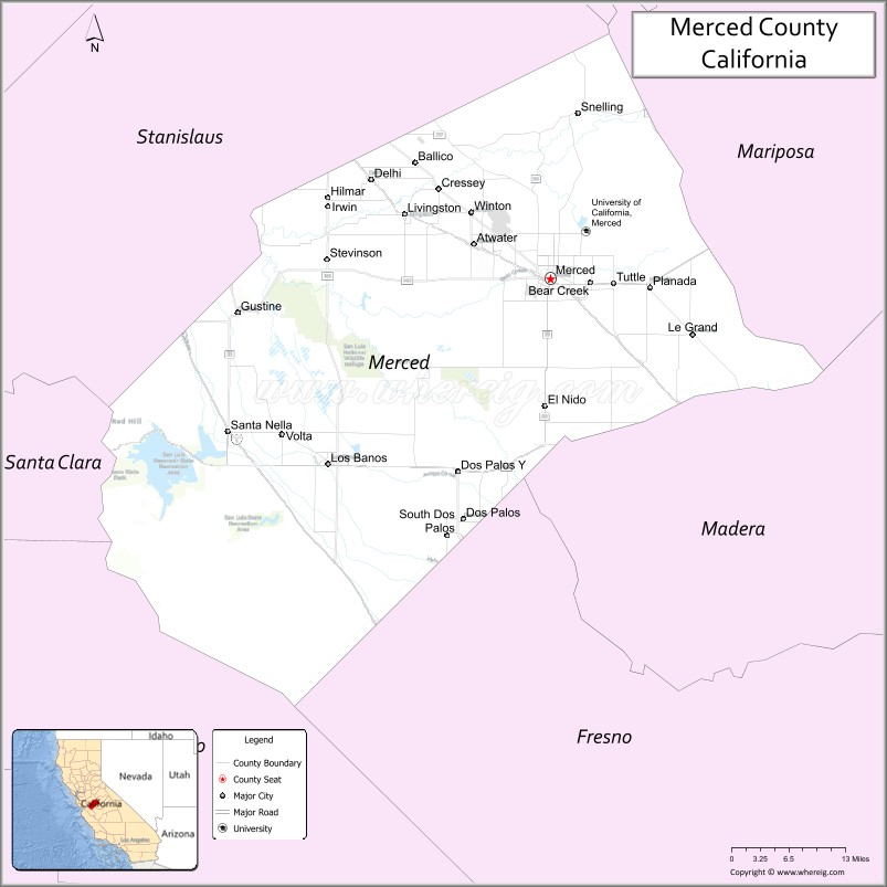
About Merced County Map, California: The map showing the county boundary, county seat, major cities, highways, water bodies and neighbouring counties.
Most Viewed Links
About Merced County, California
Merced County is a county located in the U.S. state of California. It's county seat is Merced. As per 2020 census, the population of Merced County is 286461 people and population density is square miles. According to the United States Census Bureau, the county has a total area of 1,929 sq mi (4,996 km2). Merced County was established on 1855.
Merced County is bordered by Stanislaus County to the north, San Joaquin County to the northwest, Mariposa County to the east, Madera County to the south, and Fresno County to the southwest.
The county is home to the University of California, Merced, which is the tenth and newest of the University of California campuses. Other cities in Merced County include Atwater, Los Banos, and Livingston.
The economy of Merced County is primarily based on agriculture, with crops such as almonds, cotton, and tomatoes being major contributors. The county is also home to Castle Air Force Base, which was closed in 1995 and is now a public airport.
Facts about Merced County, California
| Country | United States |
| State | California |
| Region | Central California (San Joaquin Valley) |
| County Seat | Merced |
| Named After | Merced River (Spanish for “mercy”) |
| Established | 1855 |
| Organized | 1855 |
| Coordinates | 37.1919° N, 120.7177° W |
| Total Area | 1,935 sq mi |
| Land Area | 1,934 sq mi |
| Water Area | 1 sq mi |
| Population (2020) | 281,202 |
| Population Rank | Mid-sized county in California |
| Major Cities | Merced, Los Banos, Atwater |
| Main Industries | Agriculture, Education, Healthcare, Government Services |
| Major Airport | Merced Regional Airport |
| Time Zone | Pacific Time (UTC−08:00) |
| Known For | Agricultural production, University of California, Merced, Proximity to Yosemite National Park |
| Website | https://www.co.merced.ca.us |
Ctities and Towns in Merced County
| City Name | Type | Population (2020) | Pop. Density | Area | Incorporated |
|---|---|---|---|---|---|
| Atwater | City | 31,970 | 4,866.1/sq mi (1,878.8/km2) | 6.57 sq mi (17 km2) | August 16, 1922 |
| Dos Palos | City | 5,798 | 4,294.8/sq mi (1,658.2/km2) | 1.35 sq mi (3.5 km2) | May 24, 1935 |
| Gustine | City | 6,110 | 3,941.9/sq mi (1,522.0/km2) | 1.55 sq mi (4 km2) | November 11, 1915 |
| Livingston | City | 14,172 | 3,851.1/sq mi (1,486.9/km2) | 3.68 sq mi (9.5 km2) | September 11, 1922 |
| Los Banos | City | 45,532 | 4,557.8/sq mi (1,759.8/km2) | 9.99 sq mi (25.9 km2) | May 8, 1907 |
| Merced | City | 86,333 | 3,713.2/sq mi (1,433.7/km2) | 23.25 sq mi (60.2 km2) | April 1, 1889 |
Places to Visit in Merced County
Top places to visit in Merced includes Yosemite Lake, Merced Dog Park, Merced County Fair, Laura's Fountain, Fahrens Park, Henderson Park, ROLLERLAND.
Highways in Merced County
Interstate 5, State Route 33, State Route 59, State Route 99, State Route 140, State Route 152, State Route 165.
Nearest Airports
Nearest airport of Merced is Merced Regional Airport.
- Alameda County Map
- Alpine County Map
- Amador County Map
- Butte County Map
- Calaveras County Map
- Colusa County Map
- Contra Costa County Map
- Del Norte County Map
- El Dorado County Map
- Fresno County Map
- Glenn County Map
- Humboldt County Map
- Imperial County Map
- Inyo County Map
- Kern County Map
- Kings County Map
- Lake County Map
- Lassen County Map
- Los Angeles County Map
- Madera County Map
- Marin County Map
- Mariposa County Map
- Mendocino County Map
- Merced County Map
- Modoc County Map
- Mono County Map
- Monterey County Map
- Napa County Map
- Nevada County Map
- Orange County Map
- Placer County Map
- Plumas County Map
- Riverside County Map
- Sacramento County Map
- San Benito County Map
- San Bernardino County Map
- San Diego County Map
- San Francisco County Map
- San Joaquin County Map
- San Luis Obispo County Map
- San Mateo County Map
- Santa Barbara County Map
- Santa Clara County Map
- Santa Cruz County Map
- Shasta County Map
- Sierra County Map
- Siskiyou County Map
- Solano County Map
- Sonoma County Map
- Stanislaus County Map
- Sutter County Map
- Tehama County Map
- Trinity County Map
- Tulare County Map
- Tuolumne County Map
- Ventura County Map
- Yolo County Map
- Yuba County Map
- Alabama Counties
- Alaska boroughs
- Arizona Counties
- Arkansas Counties
- California County Map
- Colorado Counties
- Connecticut Counties
- Delaware Counties
- Florida County Map
- Georgia County Map
- Hawaii Counties
- Idaho Counties
- Illinois Counties
- Indiana Counties
- Iowa Counties
- Kansas Counties
- Kentucky Counties
- Louisiana Counties
- Maine Counties
- Maryland Counties
- Massachusetts Counties
- Michigan County Map
- Minnesota Counties
- Mississippi Counties
- Missouri Counties
- Montana Counties
- Nebraska Counties
- Nevada Counties
- New York Counties
- New Hampshire Counties
- New Jersey Counties
- New Mexico Counties
- North Carolina Counties
- North Dakota Counties
- Ohio County Map
- Oklahoma Counties
- Oregon Counties
- Pennsylvania Counties
- Rhode Island Counties
- South Carolina Counties
- South Dakota Counties
- Map of Tennessee
- Texas County Map
- Utah Counties
- Vermont Counties
- Virginia Counties
- Washington Counties
- West Virginia Counties
- Wisconsin Counties
- Wyoming Counties