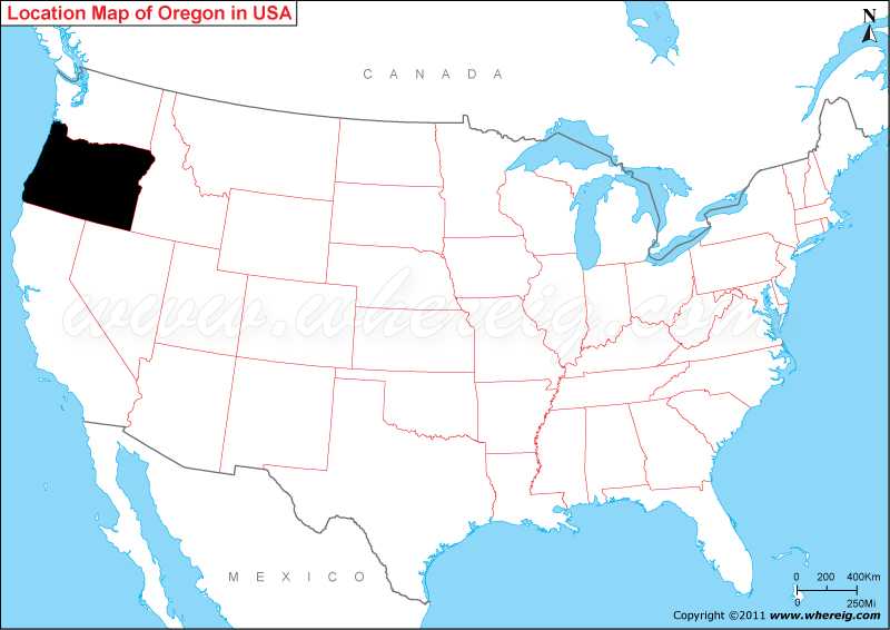
Map showing location of Oregon on the US map.
Capital city of Oregon is the Salem but the largest city of state is Portland. Geographically, the state has very much diverse feature ranging from Pacific coast in the west to the large desert in the eastern part of state; however, in between volcanoes, glaciated Cascade Mountains, dense evergreen forests, and waterfall lie.
Agriculture has larger contribution in the Oregon’s economy; the important crops are hazelnut, potatoes, peppermint, hops, apples and other fruits.
Where is Oregon Located?
As shown in the Oregon location map that Oregon is located in the Mid-western part of the United States. Oregon map also shows that it shares its border with Washington in the north, Idaho in the east, Nevada in the south-east, and California in the south. Besides, Pacific Ocean lies in the west of the Oregon.Capital city of Oregon is the Salem but the largest city of state is Portland. Geographically, the state has very much diverse feature ranging from Pacific coast in the west to the large desert in the eastern part of state; however, in between volcanoes, glaciated Cascade Mountains, dense evergreen forests, and waterfall lie.
Agriculture has larger contribution in the Oregon’s economy; the important crops are hazelnut, potatoes, peppermint, hops, apples and other fruits.
Oregon More Maps & Info
Oregon State - Quick Facts
| Country: | United States |
| Region Type: | State |
| Capital: | Salem |
| Abbreviation: | OR, Ore. US-OR |
| Largest City: | Portland |
| Area: | 98,381 sq mi (255,026 km2) |
| Population: | 3,899,353 (2012 est) |
| Joined The Union: | -14929 |
| Nickname: | Beaver State |
| Highest Point: | Mount Hood |
| Lowest Point: | Pacific Ocean |
| Timezone: | most of state Pacific: UTC −8/−7, most of Malheur County Mountain: UTC −7/−6 |
| Official Website: | www.oregon.gov |
Location Map of USA with States
- Where is Alabama (AL)
- Where is Alaska
- Where is Arizona
- Where is Arkansas Location Mapp
- Where is California
- Where is Colorado
- Where is Connecticut
- Where is Delaware
- Where is Florida
- Where is Georgia
- Where is Hawaii
- Where is Idaho State Map
- Where is Illinois
- Where is Indiana
- Where is Iowa
- Where is Kansas
- Where is Kentucky
- Where is Louisiana
- Where is Maine
- Where is Maryland
- Where is Massachusetts
- Where is Michigan
- Where is Minnesota
- Where is Mississippi
- Where is Missouri
- Where is Montana
- Where is Nebraska
- Where is Nevada
- Where is New Hampshire
- Where is New Jersey
- Where is New Mexico
- Where is New York
- Where is North Carolina
- Where is North Dakota
- Where is Ohio
- Where is Oklahoma
- Where is Oregon
- Where is Pennsylvania
- Where is Rhode Island
- Where is South Carolina
- Where is South Dakota
- Where is Tennessee
- Where is Texas
- Where is Utah
- Where is Vermont
- Where is Virginia
- Where is Washington
- Where is West Virginia
- Where is Wisconsin
- Where is Wyoming


