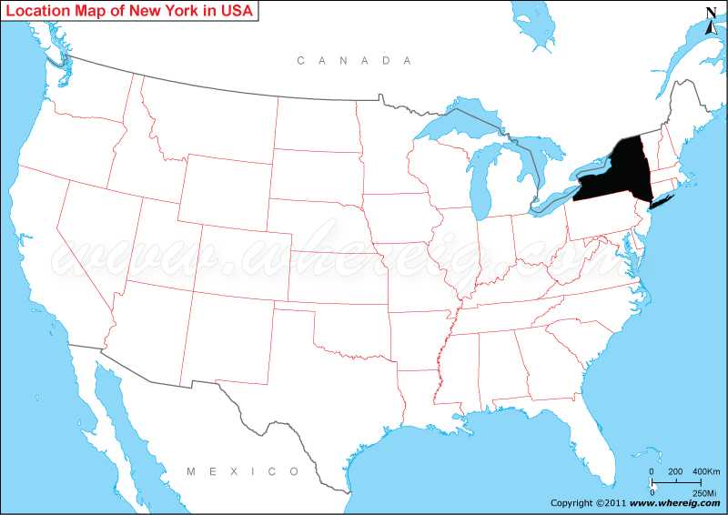
New York, is the 27th largest and the fourth-most-populous state, located in the northeastern part of the United States. It's lies at a latitude of 40° 30′ N to 45° 1′ N and a longitude of 71° 51′ W to 79° 46′ W.
Location Map of New York State

Most Viewed Links
| New York Map | Counties in New York | Cities in New York | Where is Buffalo | Where is Rochester | Where is New York City (NYC) |
Where is New York Located?
As shown in the given New York location map that New York is located in the north-east part of the United States. New York map also shows that it shares its boundary with Vermont in the east, Massachusetts and Connecticut in the south-east and Vermont and Pennsylvania in the south. Besides, New York has also the maritime border with Rhode Island and international border with Canada. The climate type of New York is humid continental climate.
In fact, New York is more often written and spoken as New York State in order to distinguish it between the New York State and New York City. Both the names i.e. city name and state name had been named for the 17th century Duke of York, James Stuart, future James II and VII of England and Scotland.
The capital city of state is Albany; however, the largest city of the state is New York City. Other important cities are: Buffalo, Rochester, Yonkers, and Syracuse.
Interestingly, New York is recognized as the financial, cultural, transportation, and manufacturing center of the US. Furthermore, it is one of the states of the US that is visited by maximum foreigners.
The economy of the state depends upon agriculture, manufacturing, finance, and other industries. Important industries are printing and publishing, scientific instruments, electric equipment, chemical products, machinery, and tourism. And, the agriculture products are dairy products, cattle and other livestock, vegetables, nursery stock, and fruits.
New York State Facts
| New York Location: | Northeastern part of the United States |
| New York Coordinates: | 40.7128° N, 74.0060° W |
| Country: | United States |
| Region Type: | State |
| Capital: | Albany |
| Abbreviation: | NY, US-NY |
| Largest City: | New York City |
| Area: | 54,556 sq mi (141,300 km2) |
| Population: | 19,453,561 [4th] (2019 est) |
| Pop Density: | 416.42/sq mi (159/km2) |
| Joined The Union: | -40698 |
| Nickname: | The Empire State |
| Highest Point: | Mount Marcy |
| Lowest Point: | Atlantic Ocean |
| Timezone: | Eastern: UTC -5/-4 |
| Official Website: | www.ny.gov |
- Where is Akron
- Where is Anaheim
- Where is Anchorage
- Where is Arlington
- Where is Aurora
- Where is Baltimore
- Where is Baton Rouge
- Where is Birmingham
- Where is Boise City
- Where is Boston
- Where is Buffalo
- Where is Chandler
- Where is Charlotte
- Where is Chesapeake
- Where is Chula Vista
- Where is Cincinnati
- Where is Cleveland
- Where is Colorado Springs
- Where is Columbus
- Where is Corpus Christi
- Where is Des Moines
- Where is Detroit
- Where is Durham
- Where is El Paso
- Where is Fayetteville
- Where is Fort Wayne
- Where is Freemont
- Where is Fresno
- Where is Garland
- Where is Gilbert
- Where is Glendale
- Where is Greensboro
- Where is Henderson
- Where is Hialeah
- Where is Honolulu
- Where is Houston
- Where is Indianapolis
- Where is Irvine
- Where is Irving
- Where is Jacksonville
- Where is Jersey City
- Where is Kansas City
- Where is Laredo
- Where is Lincoln
- Where is Long Beach
- Where is Louisville
- Where is Lubbock
- Where is Madison
- Where is Memphis
- Where is Mesa
- Where is Milwaukee
- Where is Minneapolis
- Where is Modesto
- Where is Montgomery
- Where is Nashville
- Where is Newark
- Where is Norfolk
- Where is North Las Vegas
- Where is Oakland
- Where is Oklahoma City
- Where is Omaha
- Where is Orlando
- Where is Paradise
- Where is Philadelphia
- Where is Phoenix
- Where is Portland
- Where is Raleigh
- Where is Reno
- Where is Richmond
- Where is Riverside
- Where is Rochester
- Where is Sacramento
- Where is Saint Paul
- Where is Saint Petersburg
- Where is San Bernardino
- Where is San Jose
- Where is Santa Ana
- Where is Scottsdale
- Where is Shreveport
- Where is Spokane
- Where is St Louis
- Where is Stockton
- Where is Tampa
- Where is Toledo
- Where is Tucson
- Where is Tulsa
- Where is Virginia Beach
- Where is Wichita
