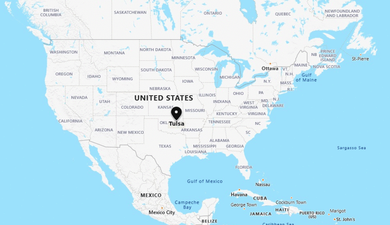
Tulsa is located in the north-east of the state. It is the second-largest city of the state Oklahoma and 45th-largest city in the United States.
Location Map of Tulsa, Oklahoma

Oklahoma More Maps & Info
About Tulsa
Tulsa is a city on the Arkansas River between the Osage Hills and the foothills of the Ozark Mountains in northeast of the U.S. state of Oklahoma. It is the 2nd largest city in the state of Oklahoma and 47th-most populous city in the United States.
Latitude and longitude Tulsa is 36.1540° N, 95.9928° W .Places to See in Tulsa:
Following are the list of Top Places to Visit in Tulsa, Oklahoma;
| Gathering Place | Blue Whale of Catoosa | Tulsa Botanic Garden | Chandler Park |
| Tulsa Zoo | River Spirit Casino Resort | Guthrie Green | Redbud Valley Nature Preserve |
| Oklahoma Aquarium | Woodward Park | ahha Tulsa | Osage Casino |
| Philbrook Museum of Art | Tulsa Air and Space Museum & Planetarium | Mohawk Park | Greenwood Cultural Center |
| Gilcrease Museum | Safari Joe's H2O | Turkey Mountain Park | Golden Driller Statue |
Facts about Tulsa City:
| 1 | Country | USA |
| 2 | State | Oklahoma |
| 3 | Location | North-East |
| 4 | Latitude | 36.07′53″N |
| 5 | Longitude | 95.56′14″W |
| 6 | Total area | 483 km2 (196 sq mi ) |
| 7 | Total Population | 396,466 |
| 8 | Zip Codes | 74101 |
| 9 | Area code | 539, 918 |
| 10 | Nearby Cities | Bixby, Sand Springs, Sapulpa, Broken Arrow |
| 11 | Major Tourists' Attraction | Woodward Park, Tulsa Symphony Orchestra, World's Largest Praying Hands, OK Aquarium |
| 12 | Nearest airport | Tulsa International Airport (about 9 miles) |
- Where is Akron
- Where is Anaheim
- Where is Anchorage
- Where is Arlington
- Where is Aurora
- Where is Baltimore
- Where is Baton Rouge
- Where is Birmingham
- Where is Boise City
- Where is Boston
- Where is Buffalo
- Where is Chandler
- Where is Charlotte
- Where is Chesapeake
- Where is Chula Vista
- Where is Cincinnati
- Where is Cleveland
- Where is Colorado Springs
- Where is Columbus
- Where is Corpus Christi
- Where is Des Moines
- Where is Detroit
- Where is Durham
- Where is El Paso
- Where is Fayetteville
- Where is Fort Wayne
- Where is Freemont
- Where is Fresno
- Where is Garland
- Where is Gilbert
- Where is Glendale
- Where is Greensboro
- Where is Henderson
- Where is Hialeah
- Where is Honolulu
- Where is Houston
- Where is Indianapolis
- Where is Irvine
- Where is Irving
- Where is Jacksonville
- Where is Jersey City
- Where is Kansas City
- Where is Laredo
- Where is Lincoln
- Where is Long Beach
- Where is Louisville
- Where is Lubbock
- Where is Madison
- Where is Memphis
- Where is Mesa
- Where is Milwaukee
- Where is Minneapolis
- Where is Modesto
- Where is Montgomery
- Where is Nashville
- Where is Newark
- Where is Norfolk
- Where is North Las Vegas
- Where is Oakland
- Where is Oklahoma City
- Where is Omaha
- Where is Orlando
- Where is Paradise
- Where is Philadelphia
- Where is Phoenix
- Where is Portland
- Where is Raleigh
- Where is Reno
- Where is Richmond
- Where is Riverside
- Where is Rochester
- Where is Sacramento
- Where is Saint Paul
- Where is Saint Petersburg
- Where is San Bernardino
- Where is San Jose
- Where is Santa Ana
- Where is Scottsdale
- Where is Shreveport
- Where is Spokane
- Where is St Louis
- Where is Stockton
- Where is Tampa
- Where is Toledo
- Where is Tucson
- Where is Tulsa
- Where is Virginia Beach
- Where is Wichita
Written and fact-checked by Whereig.com Web Team | Last Updated: January 11, 2025, 11:50 PM ET
