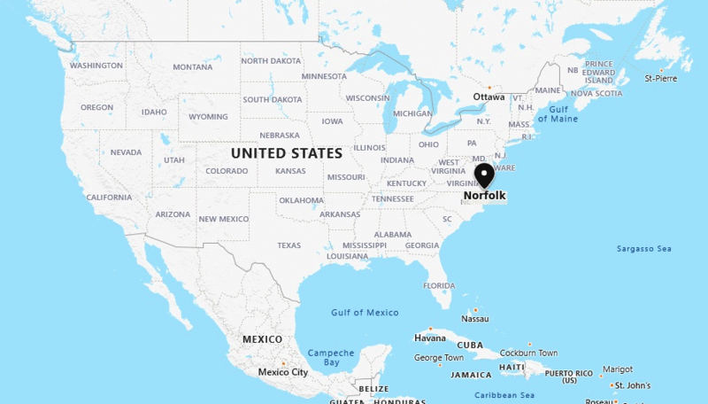
Norfolk is located in the eastern part of the state Virginia.
Norfolk, Virginia Quick Facts
| City | Norfolk |
| County | Independent City |
| State | Virginia |
| State Capital | Richmond |
| US Region | South |
| Latitude | 36.8508° N |
| Longitude | 76.2859° W |
| Elevation | 7 ft (2 m) |
| Land Area (sq mi) | 53.27 |
| Water Area (sq mi) | 42.15 |
| Total Area (sq mi) | 95.42 |
| Population (2020 Census) | 238,005 |
| Population Density (per sq mi) | 4,467 |
| ZIP Codes | 23502, 23503, 23504, 23505, 23507, 23508, 23509, 23510, 23511, 23513, 23517, 23518, 23523, 23529 |
| Area Code | 757, 948 |
| Time Zone Standard | Eastern Standard Time (UTC-5) |
| Time Zone Daylight | Eastern Daylight Time (UTC-4) |
| Currency | United States Dollar (USD) |
| FIPS Code | 51-57000 |
| Congressional District | Virginia's 3rd Congressional District |
Nearby Cities to Norfolk, Virginia
- Portsmouth, Virginia - 3 mi Southwest
- Chesapeake, Virginia - 8 mi South
- Virginia Beach, Virginia - 12 mi East
- Hampton, Virginia - 18 mi North
- Newport News, Virginia - 25 mi Northwest
- Suffolk, Virginia - 22 mi West
- Poquoson, Virginia - 28 mi North
- Williamsburg, Virginia - 45 mi Northwest
- Franklin, Virginia - 38 mi Southwest
- Elizabeth City, North Carolina - 45 mi South
Norfolk, Virginia Climate and Weather Overview
| Month | Avg High (°F) | Avg Low (°F) | Avg Rainfall (in) |
|---|---|---|---|
| January | 50 | 32 | 3.4 |
| April | 69 | 49 | 3.2 |
| July | 89 | 73 | 5.5 |
| October | 73 | 54 | 3.3 |
| Annual | 70 | 52 | 46.5 |
| Climate Classification (Köppen) | Humid Subtropical (Cfa) |
| Annual Rainfall | 46.5 in |
| Annual Sunshine Days | 214 |
| Hurricane/Tornado Risk | Moderate Hurricane Risk |
| Snowfall | 5.8 in |
Driving Distances from Norfolk, Virginia
| City | State | Distance (mi) | Approx. Drive Time |
|---|---|---|---|
| Virginia Beach | Virginia | 12 | 20 min |
| Chesapeake | Virginia | 8 | 15 min |
| Portsmouth | Virginia | 3 | 10 min |
| Hampton | Virginia | 18 | 25 min |
| Newport News | Virginia | 25 | 30 min |
| Williamsburg | Virginia | 45 | 50 min |
| Richmond | Virginia | 95 | 1 hr 40 min |
| Raleigh | North Carolina | 190 | 3 hr 10 min |
| Washington | District of Columbia | 205 | 3 hr 30 min |
| Baltimore | Maryland | 240 | 4 hr |
Transportation and Connectivity in Norfolk, Virginia
| Airport Name | Norfolk International Airport |
| IATA Code | ORF |
| Port | Port of Virginia - Norfolk Harbor |
| Major Highways | I-64, I-264, I-564, US 13, US 58 |
| Train/Amtrak Service | Available via Norfolk Amtrak Station |
| Local Bus/Transit Service | Hampton Roads Transit (HRT) and The Tide Light Rail |
- Interstate 64 - Major route connecting Norfolk with Hampton Roads, Richmond, and western Virginia.
- Interstate 264 - Connects Norfolk with Virginia Beach and Portsmouth.
- Interstate 564 - Provides direct access to Naval Station Norfolk and port facilities.
- U.S. Route 13 - Regional corridor linking Norfolk with the Eastern Shore and North Carolina.
- U.S. Route 58 - Important east-west route serving southeastern Virginia.
Key Landmarks and Places to Visit in Norfolk, Virginia
| Landmark Name | Type |
|---|---|
| USS Wisconsin | Historic Ship Museum |
| Nauticus | Maritime Museum |
| Norfolk Botanical Garden | Botanical Garden |
| Virginia Zoo | Zoo |
| Chrysler Museum of Art | Museum |
| Town Point Park | Urban Park |
| MacArthur Memorial | Historic Museum |
| Waterside District | Entertainment District |
| Hermitage Museum and Gardens | Museum |
| Naval Station Norfolk | Military Landmark |
Economy and Major Employers in Norfolk, Virginia
| Sector | Major Employer or Industry | Notes |
|---|---|---|
| Military | Naval Station Norfolk | Largest naval base in the world. |
| Port Operations | Port of Virginia | Major East Coast shipping and logistics hub. |
| Healthcare | Sentara Healthcare | Leading regional healthcare provider. |
| Higher Education | Old Dominion University | Major research university and employer. |
| Defense | Defense Contractors | Supports military and federal operations. |
| Tourism | Hospitality and Waterfront Attractions | Important contributor to the local economy. |
| Transportation | Logistics and Warehousing | Benefits from port and rail connectivity. |
| Government | Federal and Local Agencies | Provides significant public-sector employment. |
Colleges and Universities in Norfolk, Virginia
| Institution Name | Type (Public/Private) | Level | Notable For |
|---|---|---|---|
| Old Dominion University | Public | University | Research, engineering, and maritime studies |
| Norfolk State University | Public | University | Historically Black university education |
| Tidewater Community College | Public | Community College | Transfer and workforce programs |
| Eastern Virginia Medical School | Public | University | Medical education and research |
| Virginia Wesleyan University | Private | University | Liberal arts and professional studies |
| Regent University | Private | University | Law, business, and Christian education |
| ECPI University | Private | University | Technology and healthcare programs |
| Centura College | Private | College | Career-focused technical training |
Waterbodies in Norfolk, Virginia
Chesapeake Bay, Elizabeth River, Lafayette River, Hampton Roads Harbor, Willoughby Bay, Pretty Lake, Little Creek, Broad Creek, Tanner Creek, Lake Whitehurst
Golf Courses in Norfolk, Virginia
Sewells Point Golf Course, Ocean View Golf Course, Lambert's Point Golf Course, Norfolk Country Club, Cypress Point Country Club, Riverfront Golf Club, Virginia Beach National Golf Club, Heron Ridge Golf Club, Greenbrier Country Club, Honey Bee Golf Club
Norfolk, Virginia - Key Historical Facts
- Norfolk was founded in 1682 and is one of the oldest cities in Virginia.
- The city played an important role in colonial trade due to its deep natural harbor.
- Norfolk suffered extensive destruction during the American Revolution when British forces occupied the city.
- The establishment and growth of the U.S. Navy transformed Norfolk into a major military center.
- Its strategic harbor helped make Norfolk one of the most important port cities on the East Coast.
- Today Norfolk is recognized for its naval presence, maritime commerce, higher education, and waterfront attractions.
US Cities Location
- Where is Akron
- Where is Anaheim
- Where is Anchorage
- Where is Arlington
- Where is Aurora
- Where is Baltimore
- Where is Baton Rouge
- Where is Birmingham
- Where is Boise City
- Where is Boston
- Where is Buffalo
- Where is Chandler
- Where is Charlotte
- Where is Chesapeake
- Where is Chula Vista
- Where is Cincinnati
- Where is Cleveland
- Where is Colorado Springs
- Where is Columbus
- Where is Corpus Christi
- Where is Des Moines
- Where is Detroit
- Where is Durham
- Where is El Paso
- Where is Fayetteville
- Where is Fort Wayne
- Where is Freemont
- Where is Fresno
- Where is Garland
- Where is Gilbert
- Where is Glendale
- Where is Greensboro
- Where is Henderson
- Where is Hialeah
- Where is Honolulu
- Where is Houston
- Where is Indianapolis
- Where is Irvine
- Where is Irving
- Where is Jacksonville
- Where is Jersey City
- Where is Kansas City
- Where is Laredo
- Where is Lincoln
- Where is Long Beach
- Where is Louisville
- Where is Lubbock
- Where is Madison
- Where is Memphis
- Where is Mesa
- Where is Milwaukee
- Where is Minneapolis
- Where is Modesto
- Where is Montgomery
- Where is Nashville
- Where is Newark
- Where is Norfolk
- North Las Vegas
- Oakland
- Oklahoma City
- Where is Omaha
- Where is Orlando
- Where is Paradise
- Where is Philadelphia
- Where is Phoenix
- Where is Portland
- Where is Raleigh
- Where is Reno
- Where is Richmond
- Where is Riverside
- Where is Rochester
- Where is Sacramento
- Where is Saint Paul
- Where is Saint Petersburg
- Where is San Bernardino
- Where is San Jose
- Where is Santa Ana
- Where is Scottsdale
- Where is Shreveport
- Where is Spokane
- Where is St Louis
- Where is Stockton
- Where is Tampa
- Where is Toledo
- Where is Tucson
- Where is Tulsa
- Where is Virginia Beach
- Where is Wichita