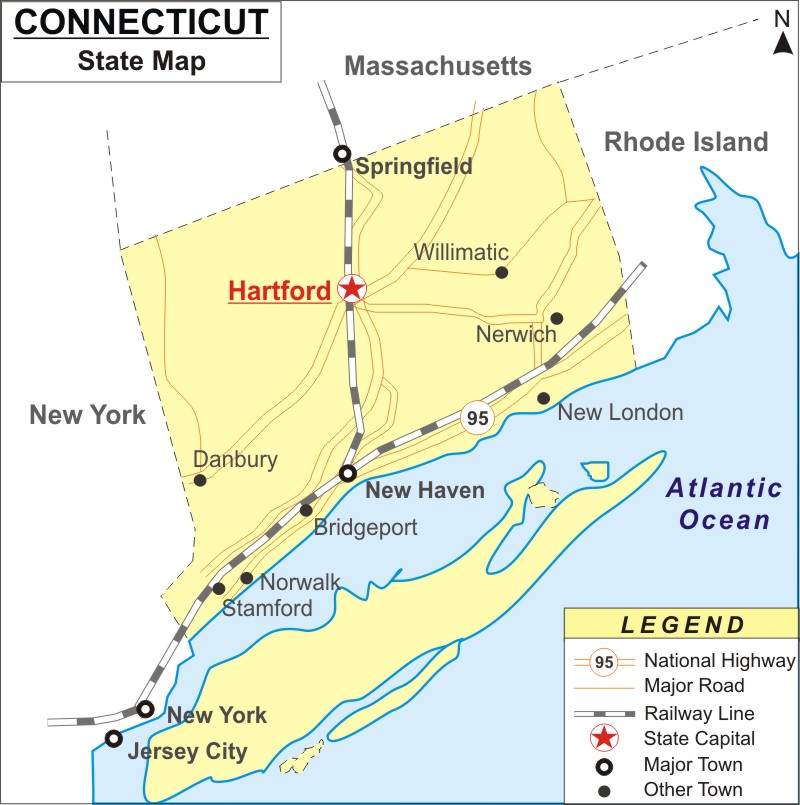
About Map: Connecticut Map showing the capital, state boundary, roads, rail network,rivers, interstate highways, major cities and towns.
Facts About Connecticut
| State Name | Connecticut |
| Country | United States |
| Continent | North America |
| Capital City | Hartford |
| Lagest city | Bridgeport |
| Abbreviation | CT, Conn. US-CT |
| Joined the Union | January 9, 1788 (5th) |
| Nickname | The Constitution State |
| area | 5,543 sq mi (14,357 km2) |
| Timezone | Eastern: UTC −5/−4 |
| Population | 3,596,080 (2013 est) |
| Highest Point | Massachusetts border on south slope of Mount Frissell |
| Lowest Point | Long Island Sound |
| Official Website | https://www.ct.gov/ |
Connecticut Map: Connecticut is one of the New England States, which is located in the southernmost state in the United States. It is bounded to the east by Rhode Island, to the north by Massachusetts, to the west by New York, and to the south by Long Island Sound. Hartford is the state capital, and Bridgeport is the most populous city. Bridgeport, New Haven, Stamford, Waterbury, Norwalk, Danbury, New Britain, Greenwich, and Bristol are some additional significant towns and cities (by population). Connecticut has 169 incorporated towns, some of which also include cities and villages.
Connecticut Map
Connecticut map provided on this page shows all of the areas that are located in the state. The Connecticut Map depicts not only the state borders, but also major highways, major roads, railway lines, the state capital, and other towns. The Connecticut Map can be used to locate locations based on their orientation. The Connecticut Map on this website is free of charge. It is freely available for download.
Connecticut Map Illustrates the Location of its Major Cities
Connecticut's major cities are denoted on the Connecticut map. The major cities of Connecticut such as Ansonia, Bridgeport, Bristol, Danbury, Darien, Derby, East Hartford, East Haven, Hartford, Manchester, Meriden, Middletown, Milford, Naugatuck, New Britain, New Haven, New London, Newington, North Haven, Norwalk, Norwich, Orange, Shelton, Stamford, Storrs, Stratford, Torrington, Trumbull, Waterbury, West Hartford, West Hartford, Wethersfield, Willimantic and Windsor Locks can be located on Connecticut Map.
Connecticut Map Shows National Highways & Routes
Connecticut Map indicates the National Highways and Routes of Connecticut. The detailed map displays the boundaries of the US state of Connecticut, the position of Hartford, the state capital, major cities and other inhabited areas, rivers and lakes, interstate highways, major highways, and railroads. The Connecticut Map provided on this page is free and one can use for educational purposes.
Most Viewed Links
Location Map of USA with States
- Where is Alabama (AL)
- Where is Alaska
- Where is Arizona
- Where is Arkansas Location Mapp
- Where is California
- Where is Colorado
- Where is Connecticut
- Where is Delaware
- Where is Florida
- Where is Georgia
- Where is Hawaii
- Where is Idaho State Map
- Where is Illinois
- Where is Indiana
- Where is Iowa
- Where is Kansas
- Where is Kentucky
- Where is Louisiana
- Where is Maine
- Where is Maryland
- Where is Massachusetts
- Where is Michigan
- Where is Minnesota
- Where is Mississippi
- Where is Missouri
- Where is Montana
- Where is Nebraska
- Where is Nevada
- Where is New Hampshire
- Where is New Jersey
- Where is New Mexico
- Where is New York
- Where is North Carolina
- Where is North Dakota
- Where is Ohio
- Where is Oklahoma
- Where is Oregon
- Where is Pennsylvania
- Where is Rhode Island
- Where is South Carolina
- Where is South Dakota
- Where is Tennessee
- Where is Texas
- Where is Utah
- Where is Vermont
- Where is Virginia
- Where is Washington
- Where is West Virginia
- Where is Wisconsin
- Where is Wyoming


