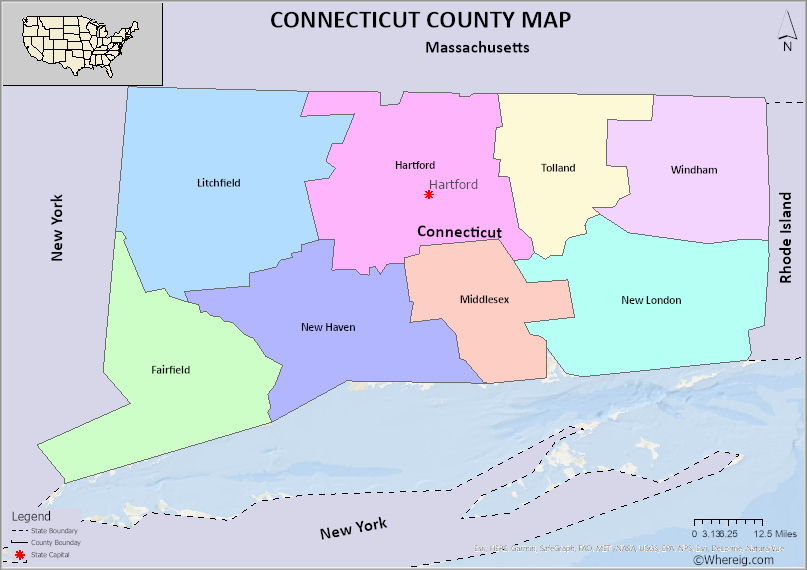
The U.S. state of Connecticut is divided into 8 Counties. Explore the Connecticut County Map, list of Counties in Connecticut along with their County Seats in alphabetical order along with their population, areas and the date of formation.
Connecticut County Map
 About Connecticut County Map: The map showing the county boundary, all counties boundary, state capital and neighbouring states.
Most Viewed Links
About Connecticut County
Connecticut is a state of United States of America which was one among 13 original states of U.S. This is also one of the six New England States. Connecticut is situated in the northeastern part of United States of America. Connecticut is known by its official nick name ‘Constitutional State’ The state shares the borders with Massachusetts to the north, Rhode Island to the east, Long Island Sound to the south and New York to the west. Connecticut has 4842 square meters area which is about 12542 square kilometers. The capital of Connecticut is Hartford. There are 8 counties in the state of Connecticut. Litchfield county is the biggest county in the aspect of possessing geographical area while Windham is the smallest one. The four major and important cities of the state are Bridgeport, New Haven, Stamford and Hartford. There 169 towns, 21 cities and 9 boroughs which fall under 8 counties. The best county to live in the state of Connecticut is Fairfield and it is the mostly populated county as well as. The least populated county is Windham.
Connecticut has a unique place in the world as it is the home for the first Colour Television, Phone book, Hamburger, Polaroid Camera, Nuclear- Powered submarine, and Helicopter. The credit of issuing the first traffic law about speed limit goes to Connecticut. The highest peak in the state of Connecticut is Bear Mountain which is in Salisbury in the northwest conner of state.
Like all other states of United States of America, Connecticut has also three branches of government. They are Executive branch, Legislative branch and Judicial branch. The state does not have county government. Counties of Connecticut are basically used for geographical and statical purpose. For ease of administration the state is branched as nine councils of government.
The U.S. state of Connecticut has 8 Counties. This is list of Connecticut Counties and County Seats in alphabetical order and check their population, areas and the date of formation.
List of Connecticut Counties
| S.N | County | Seat | FIPS code | Established | Population | Area |
|---|---|---|---|---|---|---|
| 1 | Fairfield County | Bridgeport | 1 | 1666 | 959768 | 626 sq mi (1,621 km2) |
| 2 | Hartford County | Hartford | 3 | 1666 | 896854 | 736 sq mi (1,906 km2) |
| 3 | Litchfield County | N/A | 5 | 1751 | 185000 | 920 sq mi (2,383 km2) |
| 4 | Middlesex County | Middletown | 7 | 1785 | 164759 | "369 sq mi (956 km2) |
| 5 | New Haven County | New Haven | 9 | 1666 | 863700 | 606 sq mi (1,570 km2) |
| 6 | New London County | New London | 11 | 1666 | 268805 | 666 sq mi (1,725 km2) |
| 7 | Tolland County | Rockville | 13 | 1785 | 150293 | "410 sq mi (1,062 km2) |
| 8 | Windham County | Willimantic | 15 | 1726 | 116418 | 513 sq mi (1,329 km2) |
- Alabama Counties
- Alaska boroughs
- Arizona Counties
- Arkansas Counties
- California County Map
- Colorado Counties
- Connecticut Counties
- Delaware Counties
- Florida County Map
- Georgia County Map
- Hawaii Counties
- Idaho Counties
- Illinois Counties
- Indiana Counties
- Iowa Counties
- Kansas Counties
- Kentucky Counties
- Louisiana Counties
- Maine Counties
- Maryland Counties
- Massachusetts Counties
- Michigan County Map
- Minnesota Counties
- Mississippi Counties
- Missouri Counties
- Montana Counties
- Nebraska Counties
- New Hampshire Counties
- New Jersey Counties
- New Mexico Counties
- North Carolina Counties
- North Dakota Counties
- Oklahoma Counties
- Oregon Counties
- Pennsylvania Counties
- Rhode Island Counties
- South Carolina Counties
- South Dakota Counties
- Map of Tennessee
- Texas County Map
- Utah Counties
- Vermont Counties
- Virginia Counties
- Washington Counties
- West Virginia Counties
- Wisconsin Counties
- Wyoming Counties
- Nevada Counties
- New York Counties
- Ohio County Map
Written and Fact-checked by Whereig Web Team | Last Updated: January 13, 2024, 01:05 PM ET
