Map of New London County - New London County is a county located in the U.S. state of Connecticut. New London County Map showing cities, highways, important places and water bodies. Get Where is New London County located in the map, major cities in New London county, population, areas, and places of interest.
New London County Map, Connecticut
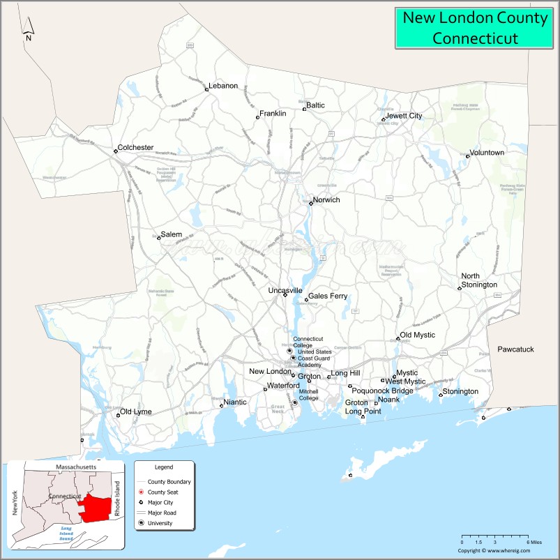
About New London County Map, Connecticut: The map showing the county boundary, county seat, major cities, highways, water bodies and neighbouring counties.
Most Viewed Links
Map of New London County, Connecticut
New London County is a county located in the U.S. state of Connecticut. It's county seat is New London. As per 2020 census, the population of New London County is 268805 people and population density is square miles. According to the United States Census Bureau, the county has a total area of 666 sq mi (1,725 km2). New London County was established on 1666.
New London County Facts
| Continent | North America |
| Country | United States |
| State | Connecticut |
| County Seat | None (Connecticut counties have no county government) |
| Largest City/Town | New London |
| Established | 1666 |
| Total Area | 772 sq mi (1,999 sq km) |
| Land Area | 665 sq mi (1,722 sq km) |
| Water Area | 107 sq mi (277 sq km) |
| Population | 268,555 (Census 2020) |
| Population Density | 404 people per sq mi |
| Time Zone | Eastern Time Zone (ET) |
| Major Highways | Interstate 95, Interstate 395, U.S. Route 1, Connecticut Route 2 |
| Major Rivers | Thames River, Mystic River, Connecticut River |
| Neighboring Counties | Middlesex County, Windham County, Washington County (Rhode Island) |
| Famous For | Maritime heritage, casinos, submarine history, coastal tourism, Mystic Seaport |
| Top Attractions | Mystic Seaport Museum, Mystic Aquarium, Mohegan Sun, Foxwoods Resort Casino, Ocean Beach Park |
| Official Website | Official Connecticut Website |
About New London County, Connecticut
New London County is located in southeastern Connecticut in the United States along Long Island Sound and was established in 1666. New London is the county’s largest city and an important maritime center. The county is known for coastal tourism, historic seaports, casino resorts, submarine history, beaches, and maritime attractions.
Cities and Towns in New London County, Connecticut
| City/Town | Population (Census 2020) | Latitude & Longitude |
|---|---|---|
| New London | 27,367 | 41.3557°N, 72.0995°W |
| Norwich | 40,125 | 41.5243°N, 72.0759°W |
| Groton | 38,411 | 41.3501°N, 72.0784°W |
| Mystic | 4,348 | 41.3543°N, 71.9665°W |
| Waterford | 19,571 | 41.3418°N, 72.1359°W |
| Stonington | 18,335 | 41.3357°N, 71.9059°W |
| East Lyme | 18,693 | 41.3537°N, 72.2337°W |
| Montville | 18,387 | 41.4607°N, 72.1123°W |
| Ledyard | 15,455 | 41.4390°N, 71.9962°W |
| Old Lyme | 7,628 | 41.3187°N, 72.3293°W |
Golf Courses in New London County, Connecticut
| Golf Course | Location | Latitude & Longitude |
|---|---|---|
| Lake of Isles Golf Club | North Stonington | 41.4770°N, 71.9713°W |
| Shennecossett Golf Course | Groton | 41.3184°N, 72.0487°W |
| Cedar Ridge Golf Course | East Lyme | 41.3638°N, 72.2665°W |
Roads and Highways in New London County
Major highways connect the county with Rhode Island, New York, and coastal New England communities.
- Interstate 95 - major coastal interstate through southeastern Connecticut
- Interstate 395 - north-south highway connecting Norwich with Massachusetts
- U.S. Route 1 - scenic coastal roadway through shoreline towns
- Connecticut Route 2 - regional highway linking eastern Connecticut with Hartford
- Connecticut Route 12 - route through inland communities and casino areas
Neighboring Counties of New London County
- Middlesex County (west)
- Windham County (north)
- Washington County, Rhode Island (east)
Top Attractions in New London County, Connecticut
The county offers coastal attractions, maritime museums, beaches, casinos, and historic New England villages.
- Mystic Seaport Museum - historic maritime village and sailing museum
- Mystic Aquarium - marine exhibits featuring beluga whales and sea lions
- Mohegan Sun - major casino resort with entertainment, shopping, and dining
- Foxwoods Resort Casino - large gaming and entertainment complex
- Ocean Beach Park - sandy beach, boardwalk, and family recreation in New London
- USS Nautilus and Submarine Force Museum - exhibits on submarine history and naval technology
- Mystic Downtown Area - waterfront shops, restaurants, and historic drawbridge
- Harkness Memorial State Park - gardens, mansion, and Long Island Sound views
- Olde Mistick Village - shopping and dining destination with New England architecture
- Connecticut College Arboretum - walking trails and botanical attractions
Distance from New London County to Nearby Cities
The following distances are measured by road (driving).
- New London to Providence (Providence County), Rhode Island - 48 mi (77 km)
- New London to Hartford (Hartford County), Connecticut - 49 mi (79 km)
- New London to New Haven (New Haven County), Connecticut - 51 mi (82 km)
- New London to Boston (Suffolk County), Massachusetts - 104 mi (167 km)
- New London to Bridgeport (Fairfield County), Connecticut - 76 mi (122 km)
- New London to Albany (Albany County), New York - 132 mi (212 km)
- New London to New York City (New York County), New York - 126 mi (203 km)
- New London to Philadelphia (Philadelphia County), Pennsylvania - 228 mi (367 km)
- New London to Portland (Cumberland County), Maine - 194 mi (312 km)
- New London to Baltimore (Baltimore City), Maryland - 330 mi (531 km)
- New London to Washington, D.C. - 372 mi (599 km)
- New London to Buffalo (Erie County), New York - 454 mi (731 km)
FAQs about New London County
New London County is located in southeastern Connecticut along Long Island Sound.
New London County has a population of 268,555 according to the Census 2020.
The county is known for maritime heritage, casinos, beaches, submarine history, and Mystic Seaport.
Major highways include Interstate 95, Interstate 395, U.S. Route 1, and Connecticut Route 2.
Yes, New London County has golf facilities including Lake of Isles Golf Club and Shennecossett Golf Course.
References
- QuickFacts - U.S. Census Bureau
- United States Census Bureau
- United States Geological Survey (USGS)
- Connecticut State Government
- National Geodetic Survey
- Alabama Counties
- Alaska boroughs
- Arizona Counties
- Arkansas Counties
- California County Map
- Colorado Counties
- Connecticut Counties
- Delaware Counties
- Florida County Map
- Georgia County Map
- Hawaii Counties
- Idaho Counties
- Illinois Counties
- Indiana Counties
- Iowa Counties
- Kansas Counties
- Kentucky Counties
- Louisiana Counties
- Maine Counties
- Maryland Counties
- Massachusetts Counties
- Michigan County Map
- Minnesota Counties
- Mississippi Counties
- Missouri Counties
- Montana Counties
- Nebraska Counties
- Nevada Counties
- New York Counties
- New Hampshire Counties
- New Jersey Counties
- New Mexico Counties
- North Carolina Counties
- North Dakota Counties
- Ohio County Map
- Oklahoma Counties
- Oregon Counties
- Pennsylvania Counties
- Rhode Island Counties
- South Carolina Counties
- South Dakota Counties
- Map of Tennessee
- Texas County Map
- Utah Counties
- Vermont Counties
- Virginia Counties
- Washington Counties
- West Virginia Counties
- Wisconsin Counties
- Wyoming Counties