Map of Tolland County - Tolland County is a county located in the U.S. state of Connecticut. Tolland County Map showing cities, highways, important places and water bodies. Get Where is Tolland County located in the map, major cities in Tolland county, population, areas, and places of interest.
Tolland County Map, Connecticut
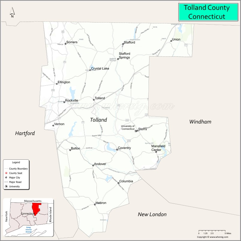
About Tolland County Map, Connecticut: The map showing the county boundary, county seat, major cities, highways, water bodies and neighbouring counties.
Most Viewed Links
Map of Tolland County, Connecticut
Tolland County is a county located in the U.S. state of Connecticut. It's county seat is Rockville. As per 2020 census, the population of Tolland County is 150293 people and population density is square miles. According to the United States Census Bureau, the county has a total area of 410 sq mi (1,062 km2). Tolland County was established on 1785.
Tolland County Facts
| Continent | North America |
| Country | United States |
| State | Connecticut |
| County Seat | None (Connecticut counties have no county government) |
| Largest City/Town | Vernon |
| Established | 1785 |
| Total Area | 418 sq mi (1,083 sq km) |
| Land Area | 410 sq mi (1,062 sq km) |
| Water Area | 8 sq mi (21 sq km) |
| Population | 149,788 (Census 2020) |
| Population Density | 365 people per sq mi |
| Time Zone | Eastern Time Zone (ET) |
| Major Highways | Interstate 84, Interstate 384, U.S. Route 44, Connecticut Route 32 |
| Major Rivers | Willimantic River, Hockanum River, Fenton River |
| Neighboring Counties | Hartford County, Windham County, New London County, Hampden County (Massachusetts) |
| Famous For | University communities, rural New England scenery, parks, agriculture, outdoor recreation |
| Top Attractions | University of Connecticut nearby, Shenipsit State Forest, Tolland Green, Stafford Motor Speedway, hiking trails |
| Official Website | Official Connecticut Website |
About Tolland County, Connecticut
Tolland County is located in northeastern Connecticut in the United States and was established in 1785. Vernon is the county’s largest municipality and serves as a regional commercial center. The county is known for scenic rural landscapes, university communities near the University of Connecticut, forests, parks, agriculture, and outdoor recreation.
Cities and Towns in Tolland County, Connecticut
| City/Town | Population (Census 2020) | Latitude & Longitude |
|---|---|---|
| Vernon | 30,215 | 41.8187°N, 72.4795°W |
| Ellington | 16,426 | 41.9034°N, 72.4706°W |
| Tolland | 15,339 | 41.8715°N, 72.3687°W |
| Coventry | 12,235 | 41.7715°N, 72.3045°W |
| Stafford | 11,541 | 41.9548°N, 72.3023°W |
| Mansfield | 26,827 | 41.7658°N, 72.2331°W |
| Somers | 10,717 | 41.9859°N, 72.4451°W |
| Willington | 5,644 | 41.8632°N, 72.2545°W |
| Ashford | 4,191 | 41.8734°N, 72.1215°W |
| Bolton | 4,858 | 41.7712°N, 72.4365°W |
Golf Courses in Tolland County, Connecticut
| Golf Course | Location | Latitude & Longitude |
|---|---|---|
| Tallwood Country Club | Hebron | 41.7052°N, 72.3551°W |
| Ellington Ridge Country Club | Ellington | 41.9058°N, 72.4463°W |
| Willimantic Country Club | Willimantic | 41.7162°N, 72.1970°W |
Roads and Highways in Tolland County
Major highways connect the county with Hartford, Massachusetts, and eastern Connecticut communities.
- Interstate 84 - primary east-west interstate through Tolland County
- Interstate 384 - connector highway toward Hartford metropolitan areas
- U.S. Route 44 - regional route through rural and university communities
- Connecticut Route 32 - north-south roadway through eastern Connecticut
- Connecticut Route 195 - route connecting Mansfield with the University of Connecticut area
Neighboring Counties of Tolland County
- Hartford County (west)
- Windham County (east)
- New London County (southeast)
- Hampden County, Massachusetts (north)
Top Attractions in Tolland County, Connecticut
The county offers parks, forests, university attractions, scenic drives, and outdoor recreation.
- University of Connecticut nearby - major university campus with museums, athletics, and cultural events
- Shenipsit State Forest - hiking, nature trails, and scenic outdoor recreation
- Tolland Green - historic New England town green with colonial architecture
- Stafford Motor Speedway - motorsports and racing events
- Nipmuck State Forest - camping, hiking, and wildlife viewing
- Mansfield Hollow State Park - boating, fishing, and picnic areas
- Hop River State Park Trail - biking and walking trail through scenic countryside
- Coventry Farmers Markets and Historic Sites - rural culture and local food attractions
- Soapstone Mountain - scenic observation tower and hiking destination
- Local Vineyards and Orchards - seasonal fruit picking and wine tasting experiences
Distance from Tolland County to Nearby Cities
The following distances are measured by road (driving).
- Vernon to Hartford (Hartford County), Connecticut - 14 mi (23 km)
- Vernon to Springfield (Hampden County), Massachusetts - 27 mi (43 km)
- Vernon to New Haven (New Haven County), Connecticut - 50 mi (80 km)
- Vernon to Providence (Providence County), Rhode Island - 63 mi (101 km)
- Vernon to Boston (Suffolk County), Massachusetts - 92 mi (148 km)
- Vernon to Bridgeport (Fairfield County), Connecticut - 69 mi (111 km)
- Vernon to Albany (Albany County), New York - 89 mi (143 km)
- Vernon to New York City (New York County), New York - 128 mi (206 km)
- Vernon to Philadelphia (Philadelphia County), Pennsylvania - 230 mi (370 km)
- Vernon to Portland (Cumberland County), Maine - 183 mi (294 km)
- Vernon to Baltimore (Baltimore City), Maryland - 331 mi (533 km)
- Vernon to Washington, D.C. - 373 mi (600 km)
FAQs about Tolland County
Tolland County is located in northeastern Connecticut.
Tolland County has a population of 149,788 according to the Census 2020.
The county is known for rural scenery, parks, university communities, and outdoor recreation.
Major highways include Interstate 84, Interstate 384, U.S. Route 44, and Connecticut Route 32.
Yes, Tolland County has golf facilities including Ellington Ridge Country Club and Tallwood Country Club.
References
- QuickFacts - U.S. Census Bureau
- United States Census Bureau
- United States Geological Survey (USGS)
- Connecticut State Government
- National Geodetic Survey
- Alabama Counties
- Alaska boroughs
- Arizona Counties
- Arkansas Counties
- California County Map
- Colorado Counties
- Connecticut Counties
- Delaware Counties
- Florida County Map
- Georgia County Map
- Hawaii Counties
- Idaho Counties
- Illinois Counties
- Indiana Counties
- Iowa Counties
- Kansas Counties
- Kentucky Counties
- Louisiana Counties
- Maine Counties
- Maryland Counties
- Massachusetts Counties
- Michigan County Map
- Minnesota Counties
- Mississippi Counties
- Missouri Counties
- Montana Counties
- Nebraska Counties
- Nevada Counties
- New York Counties
- New Hampshire Counties
- New Jersey Counties
- New Mexico Counties
- North Carolina Counties
- North Dakota Counties
- Ohio County Map
- Oklahoma Counties
- Oregon Counties
- Pennsylvania Counties
- Rhode Island Counties
- South Carolina Counties
- South Dakota Counties
- Map of Tennessee
- Texas County Map
- Utah Counties
- Vermont Counties
- Virginia Counties
- Washington Counties
- West Virginia Counties
- Wisconsin Counties
- Wyoming Counties