Map of Fairfield County - Fairfield County is a county located in the U.S. state of Connecticut. Fairfield County Map showing cities, highways, important places and water bodies. Get Where is Fairfield County located in the map, major cities in Fairfield county, population, areas, and places of interest.
Fairfield County Map, Connecticut
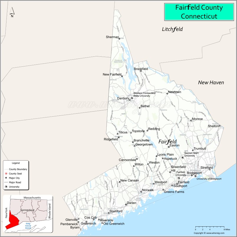
About Fairfield County Map, Connecticut: The map showing the county boundary, county seat, major cities, highways, water bodies and neighbouring counties.
Most Viewed Links
Map of Fairfield County, Connecticut
Fairfield County is a county located in the U.S. state of Connecticut. It's county seat is Bridgeport. As per 2020 census, the population of Fairfield County is 959768 people and population density is square miles. According to the United States Census Bureau, the county has a total area of 626 sq mi (1,621 km2). Fairfield County was established on 1666.
Fairfield County Facts
| Continent | North America |
| Country | United States |
| State | Connecticut |
| County Seat | None (Connecticut counties have no county government) |
| Largest City/Town | Bridgeport |
| Established | 1666 |
| Total Area | 837 sq mi (2,168 sq km) |
| Land Area | 625 sq mi (1,619 sq km) |
| Water Area | 212 sq mi (549 sq km) |
| Population | 957,419 (Census 2020) |
| Population Density | 1,532 people per sq mi |
| Time Zone | Eastern Time Zone (ET) |
| Major Highways | Interstate 95, Merritt Parkway (Route 15), Interstate 84, U.S. Route 1 |
| Major Rivers | Housatonic River, Norwalk River, Saugatuck River |
| Neighboring Counties | New Haven County, Litchfield County, Westchester County (New York), Putnam County (New York) |
| Famous For | Wealthy suburbs, financial services, Long Island Sound coastline, corporate headquarters, commuter communities near New York City |
| Top Attractions | Mystic Aquarium nearby, Beardsley Zoo, Stamford downtown, Maritime Aquarium, Long Island Sound beaches |
| Official Website | Official Connecticut Website |
About Fairfield County, Connecticut
Fairfield County is located in southwestern Connecticut in the United States along Long Island Sound and was established in 1666. Bridgeport is the largest city in the county, while Stamford and Norwalk are major economic centers. The county is known for affluent suburban communities, financial and corporate headquarters, coastal recreation, and strong commuter connections to New York City.
Cities and Towns in Fairfield County, Connecticut
| City/Town | Population (Census 2020) | Latitude & Longitude |
|---|---|---|
| Bridgeport | 148,654 | 41.1865°N, 73.1952°W |
| Stamford | 135,470 | 41.0534°N, 73.5387°W |
| Norwalk | 91,184 | 41.1176°N, 73.4082°W |
| Danbury | 86,518 | 41.3948°N, 73.4540°W |
| Fairfield | 61,737 | 41.1408°N, 73.2613°W |
| Greenwich | 63,518 | 41.0262°N, 73.6282°W |
| Westport | 27,141 | 41.1415°N, 73.3579°W |
| New Canaan | 20,622 | 41.1468°N, 73.4948°W |
| Stratford | 52,355 | 41.1845°N, 73.1332°W |
| Trumbull | 36,827 | 41.2429°N, 73.2007°W |
Golf Courses in Fairfield County, Connecticut
| Golf Course | Location | Latitude & Longitude |
|---|---|---|
| Richter Park Golf Course | Danbury | 41.4205°N, 73.5003°W |
| Sterling Farms Golf Course | Stamford | 41.0910°N, 73.5727°W |
| Fairchild Wheeler Golf Course | Fairfield | 41.2218°N, 73.2516°W |
Roads and Highways in Fairfield County
Major highways connect the county with New York City, New England, and inland Connecticut communities.
- Interstate 95 - major coastal interstate through Fairfield County
- Merritt Parkway (Route 15) - scenic commuter highway through suburban communities
- Interstate 84 - east-west route connecting Danbury with New York and Hartford
- U.S. Route 1 - historic coastal roadway through Long Island Sound communities
- Connecticut Route 7 - regional highway linking Norwalk and Danbury
Neighboring Counties of Fairfield County
- New Haven County (east)
- Litchfield County (north)
- Westchester County, New York (west)
- Putnam County, New York (northwest)
Top Attractions in Fairfield County, Connecticut
The county offers coastal recreation, museums, shopping districts, and cultural attractions near New York City.
- Beardsley Zoo - Connecticut’s only zoo featuring wildlife exhibits and family attractions
- Downtown Stamford - restaurants, theaters, offices, nightlife, and shopping
- The Maritime Aquarium at Norwalk - marine life exhibits and educational attractions
- Long Island Sound Beaches - waterfront parks, boating, and swimming destinations
- Stepping Stones Museum for Children - interactive educational exhibits in Norwalk
- Greenwich Avenue - upscale shopping and dining district
- Danbury Railway Museum - railroad exhibits and historic train displays
- Weir Farm National Historical Park - art history site and scenic walking trails
- Jennings Beach and Coastal Parks - recreation areas along Long Island Sound
- Westport Arts and Theater Scene - galleries, music venues, and cultural festivals
Distance from Fairfield County to Nearby Cities
The following distances are measured by road (driving).
- Bridgeport to New York City (New York County), New York - 61 mi (98 km)
- Bridgeport to New Haven (New Haven County), Connecticut - 22 mi (35 km)
- Bridgeport to Hartford (Hartford County), Connecticut - 58 mi (93 km)
- Bridgeport to Stamford, Connecticut - 23 mi (37 km)
- Bridgeport to Providence (Providence County), Rhode Island - 108 mi (174 km)
- Bridgeport to Boston (Suffolk County), Massachusetts - 140 mi (225 km)
- Bridgeport to Albany (Albany County), New York - 136 mi (219 km)
- Bridgeport to Philadelphia (Philadelphia County), Pennsylvania - 154 mi (248 km)
- Bridgeport to Newark (Essex County), New Jersey - 74 mi (119 km)
- Bridgeport to Baltimore (Baltimore City), Maryland - 256 mi (412 km)
- Bridgeport to Washington, D.C. - 298 mi (480 km)
- Bridgeport to Portland (Cumberland County), Maine - 224 mi (360 km)
FAQs about Fairfield County
Fairfield County is located in southwestern Connecticut along Long Island Sound.
Fairfield County has a population of 957,419 according to the Census 2020.
The county is known for affluent suburbs, financial services, coastal communities, and proximity to New York City.
Major highways include Interstate 95, the Merritt Parkway, Interstate 84, and U.S. Route 1.
Yes, Fairfield County has golf facilities including Richter Park Golf Course and Sterling Farms Golf Course.
References
- QuickFacts - U.S. Census Bureau
- United States Census Bureau
- United States Geological Survey (USGS)
- Connecticut State Government
- National Geodetic Survey
- Alabama Counties
- Alaska boroughs
- Arizona Counties
- Arkansas Counties
- California County Map
- Colorado Counties
- Connecticut Counties
- Delaware Counties
- Florida County Map
- Georgia County Map
- Hawaii Counties
- Idaho Counties
- Illinois Counties
- Indiana Counties
- Iowa Counties
- Kansas Counties
- Kentucky Counties
- Louisiana Counties
- Maine Counties
- Maryland Counties
- Massachusetts Counties
- Michigan County Map
- Minnesota Counties
- Mississippi Counties
- Missouri Counties
- Montana Counties
- Nebraska Counties
- Nevada Counties
- New York Counties
- New Hampshire Counties
- New Jersey Counties
- New Mexico Counties
- North Carolina Counties
- North Dakota Counties
- Ohio County Map
- Oklahoma Counties
- Oregon Counties
- Pennsylvania Counties
- Rhode Island Counties
- South Carolina Counties
- South Dakota Counties
- Map of Tennessee
- Texas County Map
- Utah Counties
- Vermont Counties
- Virginia Counties
- Washington Counties
- West Virginia Counties
- Wisconsin Counties
- Wyoming Counties