Home >US Map >US States >Oregon > Where is Salem

Where is Salem, Oregon?


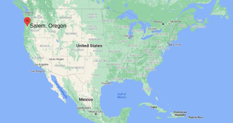
Salem is located in the north-west part of Oregon and western USA, Salem is the capital city of Oregon state. The Willamette River flows through north side of the city and it forms natural boundary between Marion and Polk counties of Oregon State.


Locationn Map of Salem


Where is Salem, Oregon
About Map - Map showing location of Salem in the central part of the Oregon.
Salem is the capital of the U.S. state of Oregon, and the county seat of Marion County. It is located in the center of the Willamette Valley alongside the Willamette River.

Though, the city has been established in the year 1842 but it became capital city in the year 1851 and it was incorporated in 1857.
The city is well connected through roadways and railways with other parts of the US. Major road ways are Interstate 5, Oregon Route 22, Oregon Route 99E etc. The city Salem is also home of Corban University, and Willamette University, and largest private employer Salem Hospital. With the population 154,637, it is the third largest city of Oregon; the largest and second largest cities are Portland and Eugene accordingly.

Major attractions of Salem city are:
  • Mission Mill Museum
  • Hallie Ford Museum of Art
  • Elsinore Theatre
  • Riverfront Park
  • Oldest buildings
  • Shopping Malls
  • Children's museum
  • Prewitt-Allen Archaeological Museum
  • Salem Armory Auditorium
  • Salem Public Library
  • Wineries and vineyards
  • Bush's Pasture Park
  • Cascade Gateway Park


Salem, Oregon Quick Facts

CitySalem
CountyMarion County, Polk County
StateOregon
State CapitalSalem
US RegionWest
Latitude44.9429° N
Longitude123.0351° W
Elevation154 ft (47 m)
Land Area (sq mi)48.45
Water Area (sq mi)0.65
Total Area (sq mi)49.10
Population (2020 Census)175,535
Population Density (per sq mi)3,623
ZIP Codes97301, 97302, 97303, 97304, 97305, 97306, 97317
Area Code503, 971
Time Zone StandardPacific Standard Time (UTC-8)
Time Zone DaylightPacific Daylight Time (UTC-7)
CurrencyUnited States Dollar (USD)
FIPS Code41-64900
Congressional DistrictOregon's 6th Congressional District

Nearby Cities to Salem, Oregon

  • Keizer, Oregon - 4 mi North
  • Dallas, Oregon - 15 mi West
  • Silverton, Oregon - 15 mi East
  • Woodburn, Oregon - 18 mi Northeast
  • Monmouth, Oregon - 16 mi West
  • Independence, Oregon - 12 mi West
  • Albany, Oregon - 25 mi South
  • McMinnville, Oregon - 26 mi Northwest
  • Newberg, Oregon - 24 mi North
  • Corvallis, Oregon - 35 mi South

Salem, Oregon Climate and Weather Overview

MonthAvg High (°F)Avg Low (°F)Avg Rainfall (in)
January47356.3
April61412.8
July83530.6
October67462.6
Annual644439.0
Climate Classification (Köppen)Warm-Summer Mediterranean (Csb)
Annual Rainfall39.0 in
Annual Sunshine Days151
Hurricane/Tornado RiskVery Low
Snowfall3.0 in

Driving Distances from Salem, Oregon

CityStateDistance (mi)Approx. Drive Time
PortlandOregon471 hr
EugeneOregon661 hr 10 min
CorvallisOregon3545 min
AlbanyOregon2530 min
McMinnvilleOregon2635 min
NewportOregon701 hr 30 min
BendOregon1302 hr 30 min
AstoriaOregon1052 hr
MedfordOregon2354 hr
SeattleWashington2203 hr 40 min

Transportation and Connectivity in Salem, Oregon

Airport NameSalem-Willamette Valley Airport
IATA CodeSLE
PortNo Seaport
Major HighwaysI-5, OR 22, OR 99E, OR 221, OR 213
Train/Amtrak ServiceAvailable via Salem Amtrak Station
Local Bus/Transit ServiceCherriots Regional Transit System
  • Interstate 5 - Major north-south corridor connecting Salem with Portland, Eugene, and California.
  • Oregon Route 22 - Connects Salem with the Oregon Coast and Central Oregon.
  • Oregon Route 99E - Historic route linking communities throughout the Willamette Valley.
  • Oregon Route 221 - Connects Salem with Polk County and wine country destinations.
  • Oregon Route 213 - Provides access toward Molalla and the Portland metropolitan area.

Key Landmarks and Places to Visit in Salem, Oregon

Landmark NameType
Oregon State CapitolHistoric Landmark
Willamette Heritage CenterMuseum
Bush's Pasture ParkUrban Park
Oregon State FairgroundsEvent Venue
Deepwood Museum & GardensHistoric Site
Riverfront City ParkRiverfront Park
Hallie Ford Museum of ArtMuseum
Minto-Brown Island ParkNature Park
Enchanted ForestTheme Park
Willamette University Historic CampusHistoric Landmark

Economy and Major Employers in Salem, Oregon

SectorMajor Employer or IndustryNotes
GovernmentState of OregonState capital and largest employer sector.
HealthcareSalem HealthMajor regional healthcare provider.
Higher EducationWillamette UniversityImportant educational institution.
AgricultureWillamette Valley AgricultureSupports food processing and distribution.
Food ProcessingAgricultural ManufacturingKey contributor to the local economy.
RetailRetail and Consumer ServicesSupports regional commerce.
LogisticsTransportation and DistributionBenefits from Interstate 5 access.
TourismGovernment and Heritage TourismDraws visitors year-round.

Colleges and Universities in Salem, Oregon

Institution NameType (Public/Private)LevelNotable For
Willamette UniversityPrivateUniversityLiberal arts, law, and public policy programs
Chemeketa Community CollegePublicCommunity CollegeWorkforce training and transfer education
Corban UniversityPrivateUniversityChristian higher education
Pacific University - Salem CampusPrivateUniversityHealthcare and graduate studies
Western Oregon UniversityPublicUniversityRegional public university nearby
George Fox University - Salem CenterPrivateUniversityAdult degree and graduate programs
Linfield University - Salem ProgramsPrivateUniversityNursing and healthcare education
Portland State University - Salem PartnershipsPublicUniversityCollaborative academic programs

Waterbodies in Salem, Oregon

Willamette River, Mill Creek, Pringle Creek, Glenn Creek, Battle Creek, Rickreall Creek, Minto Slough, Mission Lake, Detroit Lake, Santiam River

Golf Courses in Salem, Oregon

Creekside Golf Club, Salem Golf Club, Illahe Hills Country Club, McNary Golf Club, Santiam Golf Club, Meadowlawn Golf Course, OGA Golf Course, Cross Creek Golf Course, Arrowhead Golf Club, Michelbook Country Club

Salem, Oregon - Key Historical Facts

  • Salem began as a mission settlement established by Methodist missionaries in the 1840s.
  • The city became the capital of the Oregon Territory in 1851 and later remained the capital of the state.
  • Willamette University, founded in 1842, is one of the oldest universities in the western United States.
  • Agriculture and food processing helped drive Salem's growth throughout the 19th and 20th centuries.
  • The Oregon State Capitol has served as the center of state government since the late 1800s, with the current building completed in 1938.
  • Today Salem is recognized as Oregon's governmental center and a major hub of the Willamette Valley.

Oregon More Maps & Info

Oregon MapOregon County MapMap of Oregon With Cities
Oregon ZipcodesAirports in OregonWhere is Oregon
Oregon Area CodesOregon Blank MapOregon River Map
Oregon Physical MapOregon Road MapWhere is Portland


Written and fact-checked by | Last Updated: January 11, 2025, 11:50 PM ET