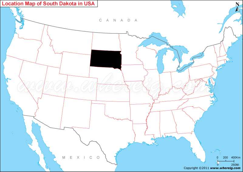
Where is South Dakota located on the US map?
Sioux Falls is the largest and capital city of South Dakota. Geographically, Missouri River divides the state into two halves i.e. east and west. These two parts is not only geographically but these are also socially distinct from each other. The residents known as “East River,” it homes most of the state’s population as well as the available fertile soil facilitates people to cultivate verities of crops; and the second part is “West River,” it is sparsely populated region and the main occupation in this region is ranching and other agriculture activities.
Besides, this part also generates revenue from the tourism industries. The most significant tourist point in the state is Mount Rushmore; some other points of interests are Badlands and Wind Cave national parks, the Crazy Horse Memorial, Custer State Park, and historic Deadwood. Black Hills located in this region is quite significant for religious purpose.
Where is South Dakota Located?
As shown in the given South Dakota location map that South Dakota is located in the Mid-western region of the United States. South Dakota map also shows that it shares its border with North Dakota in the north, Montana in the north-west, Wyoming in the west, Nebraska in the south, Iowa in the south-east, and Minnesota in the east. Interestingly, the name South Dakota is derived from the Lakota and Dakota Sioux American Indian Tribes.Sioux Falls is the largest and capital city of South Dakota. Geographically, Missouri River divides the state into two halves i.e. east and west. These two parts is not only geographically but these are also socially distinct from each other. The residents known as “East River,” it homes most of the state’s population as well as the available fertile soil facilitates people to cultivate verities of crops; and the second part is “West River,” it is sparsely populated region and the main occupation in this region is ranching and other agriculture activities.
Besides, this part also generates revenue from the tourism industries. The most significant tourist point in the state is Mount Rushmore; some other points of interests are Badlands and Wind Cave national parks, the Crazy Horse Memorial, Custer State Park, and historic Deadwood. Black Hills located in this region is quite significant for religious purpose.
South Dakota State - Quick Facts
| Country: | United States |
| Region Type: | State |
| Capital: | Pierre |
| Abbreviation: | SD, US-SD |
| Largest City: | Sioux Falls |
| Area: | 77,116 sq mi (199,905 km2) |
| Population: | 844,877 (2013 est) |
| Joined The Union: | -3710 |
| Nickname: | The Mount Rushmore State |
| Highest Point: | Harney Peak |
| Lowest Point: | Big Stone Lake on Minnesota border |
| Timezone: | eastern half Central: UTC -6/-5, western half Mountain: UTC -7/-6 |
| Official Website: | www.sd.gov |
More South Dakota Maps & Info
Location Map of USA with States
- Where is Alabama (AL)
- Where is Alaska
- Where is Arizona
- Where is Arkansas Location Mapp
- Where is California
- Where is Colorado
- Where is Connecticut
- Where is Delaware
- Where is Florida
- Where is Georgia
- Where is Hawaii
- Where is Idaho State Map
- Where is Illinois
- Where is Indiana
- Where is Iowa
- Where is Kansas
- Where is Kentucky
- Where is Louisiana
- Where is Maine
- Where is Maryland
- Where is Massachusetts
- Where is Michigan
- Where is Minnesota
- Where is Mississippi
- Where is Missouri
- Where is Montana
- Where is Nebraska
- Where is Nevada
- Where is New Hampshire
- Where is New Jersey
- Where is New Mexico
- Where is New York
- Where is North Carolina
- Where is North Dakota
- Where is Ohio
- Where is Oklahoma
- Where is Oregon
- Where is Pennsylvania
- Where is Rhode Island
- Where is South Carolina
- Where is South Dakota
- Where is Tennessee
- Where is Texas
- Where is Utah
- Where is Vermont
- Where is Virginia
- Where is Washington
- Where is West Virginia
- Where is Wisconsin
- Where is Wyoming


