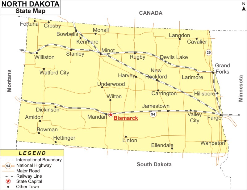
North Dakota Map: North Dakota is a state in the Midwestern region of the United States. North Dakota is the the 47th most populous and 19th largest U.S. state by area. It covers an area of 70,705 sq mi (183,123 km2), with population of 779,094 residents as of 2020 Census.
Map of North Dakota with Cities, Road, River, Highways
 About Map: North Dakota Map showing the capital, state boundary, roads, rail network,rivers, interstate highways, major cities and towns.
North Dakota More Maps & Info
About North Dakota State Map
Named after the native Dakota Sioux people, North Dakota is a state in the Upper Midwest of the United States. North Dakota shares borders with the Canadian provinces of Saskatchewan and Manitoba to the north, Minnesota to the east, South Dakota to the south, and Montana to the west. Despite being the 19th largest state, North Dakota is the fourth least populous state in the country. The capital of the state is Bismarck. The largest city of North Dakota is Fargo. All the borders of North Dakota can be seen in the North Dakota map.
North Dakota Map
The North Dakota map available on this website shows all of the places within the state. The North Dakota map displays not only the state's borders, but also main highways, railroad tracks, the state capital, and other towns. The searcher can utilize the North Dakota map to find a variety of locations. The North Dakota map on this page is offered without charge. The North Dakota map is available for download right here.
North Dakota Map Depicts the Major Cities
The major cities of North Dakota are given in the North Dakota map. The major cities of North Dakota like Bismarck, Dickinson, Fargo, Grand Forks, Jamestown, Mandan, Minot, West Fargo and Williston can be located on the North Dakota map.
North Dakota Map Indicates National Highways & Routes:
The map of North Dakota shows every National Highway and Route because they make up the state's transportation system. The information on National Highways and Routes is provided here.
Facts About North Dakota
| State Name | North Dakota |
| Country | United States |
| Continent | North America |
| Capital City | Bismarck |
| Largest city | Fargo |
| Abbreviation | ND, US-ND |
| Joined the Union | November 2, 1889 (39th) |
| Nickname | Peace Garden State, Roughrider State, Flickertail State |
| Area | 70,705 sq mi (183,123 km2) - Rank 19th |
| Timezone | UTC -6/-5 |
| Population | 779,094 (as of 2020 Census) |
| Highest Point | White Butte |
| Lowest Point | Red River of the North |
| Official Website | www.nd.gov |
