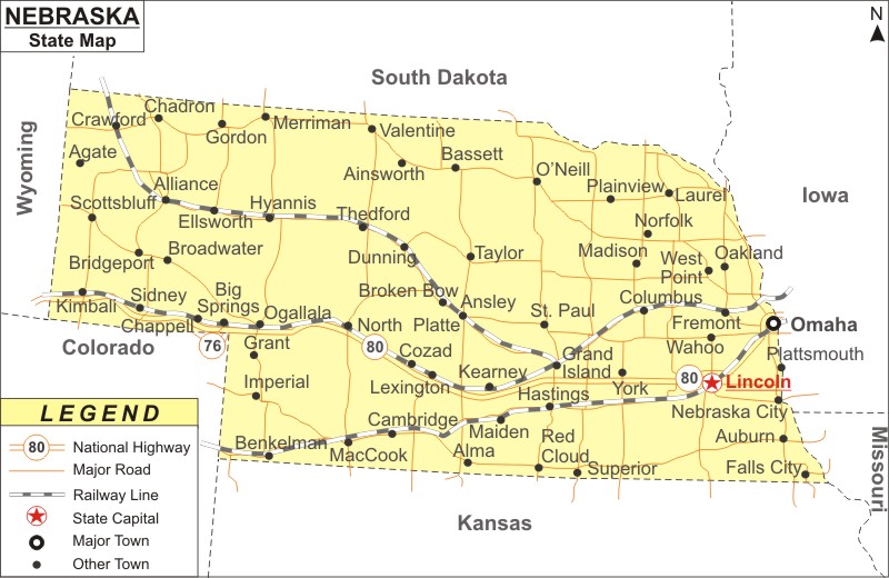
Nebraska Map: Nebraska is a state in the Midwestern region of the United States. Nebraska is the 16th largest state in the U.S. The state of NE is famous for its agricultural sector. The capital of Nebraska is Lincoln and the biggest city is Omaha. Hotels in Nebraska are equipped with all the modern-day facilities that the discerning travelers look for. The Eppley Airfield in Omaha is the biggest airport in the state.
Map of Nebraska with Cities, Road, River, Highways
 About Map: Nebraska Map showing the capital, state boundary, roads, rail network,rivers, interstate highways, major cities and towns.
Nebraska More Maps & Info
About Nebraska State Map
The detailed map displays the boundaries of the US state of Nebraska, the position of Lincoln the state capital, major cities and other inhabited areas, rivers and lakes, important highways, interstates, and railroads.
Nebraska is situated on the Great Plains. It is literally located in the heart of the United States. Nebraska encompasses a total land area of 77,220 square miles (200,000 km2) with a population of over 1.9 million and is edged by Missouri to the southeast, Iowa to the east, South Dakota to the north, Colorado to the southwest, Kansas to the south, and Wyoming to the west. A Nebraska Map is the right guide to see the sights of the Cornhusker State. The state of NE is far-famed for its scenic trails, cuisines, and entertainment getaways. Nebraska was admitted to the Union as the 37th state on March 1, 1867.
Nebraska has 93 counties and the state composed of two major land regions: the Dissected Till Plains and the Great Plains. The capital of the state is Lincoln and its largest city is Omaha, which is on the Missouri River.
Before European colonization, indigenous peoples inhabited the area that is now Nebraska for thousands of years. The Omaha, Missouria, Ponca, Pawnee, Otoe, and other branches of the Lakota, some of which migrated from eastern locations into this region, were the historic tribes in the state. In the early days of European exploration, trade, and settlement, both Spain and France aimed to dominate the area. Spain began commercial relations with the Apaches in the 1690s, then, western Nebraska was part of their domain. By 1703, France had established a regular trading relationship with the native Nebraskans living along the Missouri River, and by 1719, it had concluded treaties with a number of these groups.
During the Seven Years' War in 1762, France gave Spain the region of Louisiana. As a result, Spain and Britain were vying for supremacy along the Mississippi. The British were conducting trade with the Nebraska natives by 1773.
The Kansas-Nebraska Act, passed by the US Congress on May 30, 1854, established the territories of Kansas and Nebraska, which are separated by the parallel at 40° North. Colorado, North Dakota, South Dakota, Wyoming, and Montana were all included in the Nebraska Territory. Omaha served as Nebraska's territorial capital then.
As part of the Great Migration in the late 19th century, many African Americans moved from the South to Nebraska, mainly to Omaha, which offered working-class jobs in the railroads, meatpacking, and other sectors. A long history of the civil rights movement can be found in Omaha.
Nebraska Map
Nebraska is depicted on a stunningly accurate Nebraska map, along with its borders, Lincoln its capital, major cities and other populous areas, rivers and lakes, major highways, interstates, railroads, and airports. You can get the Nebraska map free from this page and use it for your purpose.
Nebraska Map Illustrates Major Cities
The major cities of Nebraska are shown in the Nebraska map. The major cities such Omaha, Lincoln, Bellevue, Auburn, Beatrice, Benkelman, Grand Island, Kearney, Fremont, Fairbury, Falls City, Hartington, Ainsworth, Alliance, Alma, Nebraska City, Neligh, Broken Bow, Columbus, Crawford, Hastings, Holdrege, Hyannis, Imperial, Kimball, McCook North Platte, O'Neill, Rushville, Scottsbluff, Sidney, Sidney, Sidney, Sidney..etc are shown in the Nebraska map.
Tourist attractions in Nebraska
TThe state of NE houses the following tourist attractions:
Economy of Nebraska
Agriculture is the main industry in the state. Other important industries include freight transport (by truck and railroads), telecommunications, manufacturing, insurance, and information technology.
Nebraska State Facts
| State Name | Nebraska |
| Country | United States |
| Continent | North America |
| Capital City | Lincoln |
| Largest city | Omaha |
| Abbreviation | NE |
| Nickname(s) | The Cornhusker State |
| Joined the Union | March 1, 1867 |
| Nickname | Cornhusker State |
| Area | 77,358 sq mi (200,356 km2), Rank 16th |
| Timezone | UTC−06:00 (Central) Summer (DST)- UTC−05:00 (CDT) UTC−07:00 (Mountain), Summer (DST)- UTC−06:00 (MDT) |
| Population (2020 Census) | 1,961,504 (37th) |
| Density | 24.94/sq mi (9.63/km2) - Rank 23rd |
| Highest Point | Panorama Point |
| Lowest Point | Missouri River at Kansas border |
| Official Website | www.nebraska.gov |
