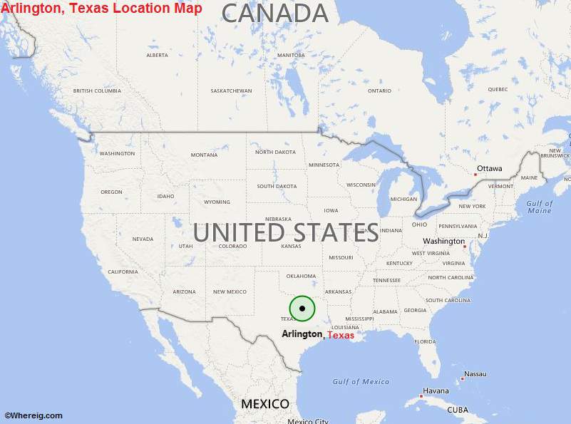
US Map showing Location Map of Arlington in Texas
With the metro city population of 6,145,037, Arlington is the seventh largest city of Texas State and 50th largest city of the United States. Arlington shares its boundary with Grand Prairie, Kennedale, Fort Worth, and Mansfield. Furthermore, Arlington is the largest city of the United States that has not public transit system. Arlington is the largest city in Texas which has not a county seat.
Though, the city is located between the cities Fort Worth and Dallas at the distance of about 20 km and 32 km accordingly but it has also various attractions; city homes University of Texas at Arlington (it is of doctoral-granting institute), assembly plant of General Motors, Cowboys Stadium, International Bowling Campus, International Bowling Museum, and it is also the headquarters of Nuclear Regulatory Commission Region IV.
The city Arlington was established in the year 1876 and incorporated in 1884. It has been named after the name of General Robert E Lee's Arlington House. Primarily, city has been grown as the cotton farming and cotton ginning centre. Today, it has quite developed economy based upon industries and services.
Though, the city is located between the cities Fort Worth and Dallas at the distance of about 20 km and 32 km accordingly but it has also various attractions; city homes University of Texas at Arlington (it is of doctoral-granting institute), assembly plant of General Motors, Cowboys Stadium, International Bowling Campus, International Bowling Museum, and it is also the headquarters of Nuclear Regulatory Commission Region IV.
The city Arlington was established in the year 1876 and incorporated in 1884. It has been named after the name of General Robert E Lee's Arlington House. Primarily, city has been grown as the cotton farming and cotton ginning centre. Today, it has quite developed economy based upon industries and services.
Arlington, Texas Quick Facts
| City | Arlington |
| County | Tarrant County |
| State | Texas |
| State Capital | Austin |
| US Region | South |
| Latitude | 32.7357° N |
| Longitude | 97.1081° W |
| Elevation | 617 ft (188 m) |
| Land Area (sq mi) | 95.86 |
| Water Area (sq mi) | 3.20 |
| Total Area (sq mi) | 99.06 |
| Population (2020 Census) | 394,266 |
| Population Density (per sq mi) | 4,113 |
| ZIP Codes | 76001, 76002, 76005, 76006, 76010, 76011, 76012, 76013, 76014, 76015, 76016, 76017, 76018, 76019 |
| Area Code | 682, 817 |
| Time Zone Standard | Central Standard Time (UTC-6) |
| Time Zone Daylight | Central Daylight Time (UTC-5) |
| Currency | United States Dollar (USD) |
| FIPS Code | 48-04000 |
| Congressional District | Texas's 6th and 33rd Congressional Districts |
Nearby Cities to Arlington, Texas
- Grand Prairie, Texas - 8 mi East
- Fort Worth, Texas - 15 mi West
- Dallas, Texas - 20 mi East
- Mansfield, Texas - 12 mi South
- Irving, Texas - 15 mi Northeast
- Euless, Texas - 10 mi North
- Bedford, Texas - 10 mi North
- Grapevine, Texas - 18 mi North
- Hurst, Texas - 9 mi North
- North Richland Hills, Texas - 13 mi North
Arlington, Texas Climate and Weather Overview
| Month | Avg High (°F) | Avg Low (°F) | Avg Rainfall (in) |
|---|---|---|---|
| January | 57 | 37 | 2.1 |
| April | 77 | 56 | 3.3 |
| July | 96 | 76 | 2.0 |
| October | 80 | 59 | 4.5 |
| Annual | 78 | 58 | 39.0 |
| Climate Classification (Köppen) | Humid Subtropical (Cfa) |
| Annual Rainfall | 39.0 in |
| Annual Sunshine Days | 232 |
| Hurricane/Tornado Risk | Moderate Tornado Risk |
| Snowfall | 1.5 in |
Driving Distances from Arlington, Texas
| City | State | Distance (mi) | Approx. Drive Time |
|---|---|---|---|
| Dallas | Texas | 20 | 25 min |
| Fort Worth | Texas | 15 | 20 min |
| Irving | Texas | 15 | 20 min |
| Denton | Texas | 38 | 45 min |
| Plano | Texas | 35 | 40 min |
| McKinney | Texas | 50 | 55 min |
| Waco | Texas | 92 | 1 hr 30 min |
| Tyler | Texas | 105 | 1 hr 50 min |
| Austin | Texas | 195 | 3 hr |
| Oklahoma City | Oklahoma | 205 | 3 hr 10 min |
Transportation and Connectivity in Arlington, Texas
| Airport Name | Dallas/Fort Worth International Airport (nearby) |
| IATA Code | DFW |
| Port | No Seaport |
| Major Highways | I-20, I-30, SH 360, SH 161, US 287 |
| Train/Amtrak Service | No Direct Amtrak Service |
| Local Bus/Transit Service | Arlington Transportation (VIA Rideshare Transit) |
- Interstate 20 - Major east-west route serving southern Arlington and connecting Dallas and West Texas.
- Interstate 30 - Primary corridor linking Arlington with Dallas and Fort Worth.
- State Highway 360 - Major north-south freeway connecting Arlington to DFW Airport and Mansfield.
- State Highway 161 - Provides access to Grand Prairie and northern Metroplex communities.
- U.S. Route 287 - Connects Arlington with Fort Worth and southeastern Texas.
Key Landmarks and Places to Visit in Arlington, Texas
| Landmark Name | Type |
|---|---|
| AT&T Stadium | Sports Venue |
| Globe Life Field | Sports Venue |
| Six Flags Over Texas | Theme Park |
| Hurricane Harbor Arlington | Water Park |
| Texas Live! | Entertainment District |
| International Bowling Museum & Hall of Fame | Museum |
| River Legacy Parks | Nature Park |
| Arlington Museum of Art | Museum |
| Levitt Pavilion Arlington | Outdoor Venue |
| Top O'Hill Terrace | Historic Site |
Economy and Major Employers in Arlington, Texas
| Sector | Major Employer or Industry | Notes |
|---|---|---|
| Higher Education | University of Texas at Arlington | Major research university and employer. |
| Manufacturing | General Motors Assembly Plant | Major automotive production facility. |
| Healthcare | Texas Health Resources Arlington | Leading regional healthcare provider. |
| Tourism | Sports and Entertainment Industry | Driven by stadiums and theme parks. |
| Retail | Retail and Hospitality Services | Supports visitor and local spending. |
| Education | Arlington Independent School District | Large public-sector employer. |
| Technology | Technology and Business Services | Growing professional employment sector. |
| Logistics | Distribution and Transportation | Benefits from central DFW location. |
Colleges and Universities in Arlington, Texas
| Institution Name | Type (Public/Private) | Level | Notable For |
|---|---|---|---|
| University of Texas at Arlington | Public | University | Engineering, business, and research programs |
| Tarrant County College - Southeast Campus | Public | Community College | Transfer and workforce education |
| Arlington Baptist University | Private | University | Christian higher education |
| Dallas College - Nearby Campuses | Public | Community College | Regional academic and technical programs |
| Texas Wesleyan University | Private | University | Professional and liberal arts programs |
| University of North Texas Health Science Center | Public | University | Healthcare and medical education |
| Remington College - Fort Worth Campus | Private | College | Career-focused training programs |
| Parker University | Private | University | Health sciences and chiropractic education |
Waterbodies in Arlington, Texas
Lake Arlington, Trinity River, Village Creek, Johnson Creek, Rush Creek, Mountain Creek Lake, Joe Pool Lake, Walnut Creek, Fish Creek, Lake Viridian
Golf Courses in Arlington, Texas
Texas Rangers Golf Club, Tierra Verde Golf Club, Lake Arlington Golf Course, Waterchase Golf Club, Shady Valley Country Club, Walnut Creek Country Club, Riverside Golf Club, Mansfield National Golf Club, Prairie Lakes Golf Course, Bear Creek Golf Club
Arlington, Texas - Key Historical Facts
- Arlington was founded in 1876 along the Texas and Pacific Railway between Dallas and Fort Worth.
- The city remained a small agricultural community until significant suburban growth occurred after World War II.
- General Motors opened a major assembly plant in Arlington in 1954, boosting industrial development.
- Six Flags Over Texas opened in 1961, becoming one of the first major theme parks in the United States.
- The arrival of professional sports venues transformed Arlington into a national entertainment destination.
- Today Arlington is recognized for higher education, sports tourism, manufacturing, and its central role in the Dallas-Fort Worth Metroplex.
Most Viewed Links
US Cities Location
- Where is Akron
- Where is Anaheim
- Where is Anchorage
- Where is Arlington
- Where is Aurora
- Where is Baltimore
- Where is Baton Rouge
- Where is Birmingham
- Where is Boise City
- Where is Boston
- Where is Buffalo
- Where is Chandler
- Where is Charlotte
- Where is Chesapeake
- Where is Chula Vista
- Where is Cincinnati
- Where is Cleveland
- Where is Colorado Springs
- Where is Columbus
- Where is Corpus Christi
- Where is Des Moines
- Where is Detroit
- Where is Durham
- Where is El Paso
- Where is Fayetteville
- Where is Fort Wayne
- Where is Freemont
- Where is Fresno
- Where is Garland
- Where is Gilbert
- Where is Glendale
- Where is Greensboro
- Where is Henderson
- Where is Hialeah
- Where is Honolulu
- Where is Houston
- Where is Indianapolis
- Where is Irvine
- Where is Irving
- Where is Jacksonville
- Where is Jersey City
- Where is Kansas City
- Where is Laredo
- Where is Lincoln
- Where is Long Beach
- Where is Louisville
- Where is Lubbock
- Where is Madison
- Where is Memphis
- Where is Mesa
- Where is Milwaukee
- Where is Minneapolis
- Where is Modesto
- Where is Montgomery
- Where is Nashville
- Where is Newark
- Where is Norfolk
- North Las Vegas
- Oakland
- Oklahoma City
- Where is Omaha
- Where is Orlando
- Where is Paradise
- Where is Philadelphia
- Where is Phoenix
- Where is Portland
- Where is Raleigh
- Where is Reno
- Where is Richmond
- Where is Riverside
- Where is Rochester
- Where is Sacramento
- Where is Saint Paul
- Where is Saint Petersburg
- Where is San Bernardino
- Where is San Jose
- Where is Santa Ana
- Where is Scottsdale
- Where is Shreveport
- Where is Spokane
- Where is St Louis
- Where is Stockton
- Where is Tampa
- Where is Toledo
- Where is Tucson
- Where is Tulsa
- Where is Virginia Beach
- Where is Wichita