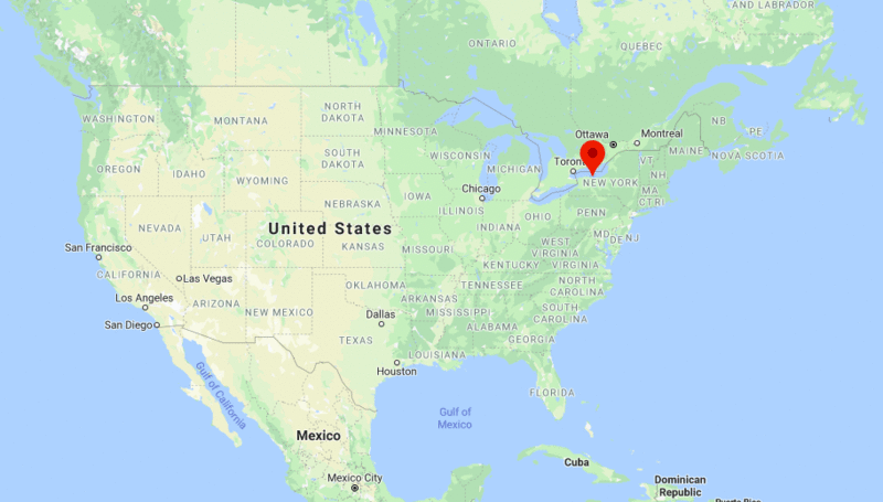
Rochester is located in the western part of the New York. It is third most populous city after New York City and Buffalo in the state of New York.
Rochester, New York Quick Facts
| City | Rochester |
| County | Monroe County |
| State | New York |
| State Capital | Albany |
| US Region | Northeast |
| Latitude | 43.1566° N |
| Longitude | 77.6088° W |
| Elevation | 505 ft (154 m) |
| Land Area (sq mi) | 35.75 |
| Water Area (sq mi) | 1.30 |
| Total Area (sq mi) | 37.05 |
| Population (2020 Census) | 211,328 |
| Population Density (per sq mi) | 5,912 |
| ZIP Codes | 14602, 14603, 14604, 14605, 14606, 14607, 14608, 14609, 14610, 14611, 14612, 14613, 14614, 14615, 14616, 14617, 14618, 14619, 14620, 14621, 14622, 14623, 14624, 14625, 14626 |
| Area Code | 585 |
| Time Zone Standard | Eastern Standard Time (UTC-5) |
| Time Zone Daylight | Eastern Daylight Time (UTC-4) |
| Currency | United States Dollar (USD) |
| FIPS Code | 36-63000 |
| Congressional District | New York's 25th Congressional District |
Nearby Cities to Rochester, New York
- Greece, New York - 6 mi Northwest
- Irondequoit, New York - 5 mi Northeast
- Brighton, New York - 4 mi Southeast
- Henrietta, New York - 8 mi South
- Webster, New York - 10 mi East
- Pittsford, New York - 8 mi Southeast
- Brockport, New York - 18 mi West
- Canandaigua, New York - 28 mi Southeast
- Batavia, New York - 35 mi West
- Geneva, New York - 45 mi Southeast
Rochester, New York Climate and Weather Overview
| Month | Avg High (°F) | Avg Low (°F) | Avg Rainfall (in) |
|---|---|---|---|
| January | 33 | 19 | 2.6 |
| April | 56 | 38 | 3.0 |
| July | 81 | 63 | 3.2 |
| October | 60 | 45 | 2.9 |
| Annual | 58 | 42 | 34.8 |
| Climate Classification (Köppen) | Humid Continental (Dfa) |
| Annual Rainfall | 34.8 in |
| Annual Sunshine Days | 165 |
| Hurricane/Tornado Risk | Low Hurricane Risk, Low Tornado Risk |
| Snowfall | 99.5 in |
Driving Distances from Rochester, New York
| City | State | Distance (mi) | Approx. Drive Time |
|---|---|---|---|
| Buffalo | New York | 74 | 1 hr 15 min |
| Syracuse | New York | 87 | 1 hr 25 min |
| Batavia | New York | 35 | 40 min |
| Canandaigua | New York | 28 | 35 min |
| Geneva | New York | 45 | 50 min |
| Ithaca | New York | 92 | 1 hr 45 min |
| Albany | New York | 226 | 3 hr 30 min |
| Erie | Pennsylvania | 170 | 2 hr 45 min |
| Cleveland | Ohio | 250 | 4 hr |
| Toronto | Ontario | 170 | 3 hr |
Transportation and Connectivity in Rochester, New York
| Airport Name | Frederick Douglass Greater Rochester International Airport |
| IATA Code | ROC |
| Port | Port of Rochester |
| Major Highways | I-90, I-390, I-490, NY 104, NY 590 |
| Train/Amtrak Service | Available via Rochester Amtrak Station |
| Local Bus/Transit Service | Regional Transit Service (RTS) |
- Interstate 90 - New York State Thruway connecting Buffalo, Rochester, Syracuse, and Albany.
- Interstate 390 - Connects Rochester with the Southern Tier and western New York.
- Interstate 490 - Primary east-west route through the city.
- New York State Route 104 - Connects Rochester with communities along Lake Ontario.
- New York State Route 590 - Major expressway serving eastern Monroe County.
Key Landmarks and Places to Visit in Rochester, New York
| Landmark Name | Type |
|---|---|
| High Falls | Natural Attraction |
| George Eastman Museum | Museum |
| Strong National Museum of Play | Museum |
| Seabreeze Amusement Park | Amusement Park |
| Seneca Park Zoo | Zoo |
| Memorial Art Gallery | Museum |
| Mount Hope Cemetery | Historic Site |
| Rochester Public Market | Market |
| Genesee Country Village & Museum | Historic Museum |
| Blue Cross Arena | Sports Venue |
Economy and Major Employers in Rochester, New York
| Sector | Major Employer or Industry | Notes |
|---|---|---|
| Healthcare | University of Rochester Medical Center | Largest employer in the region. |
| Higher Education | University of Rochester | Major research institution. |
| Technology | Optics and Photonics Industry | Rochester is a national optics hub. |
| Manufacturing | Advanced Manufacturing | Continues a long industrial tradition. |
| Government | State and Local Government | Provides significant public employment. |
| Finance | Financial Services Industry | Supports regional business activity. |
| Retail | Retail and Consumer Services | Important employment sector. |
| Tourism | Hospitality and Attractions | Draws visitors throughout the year. |
Colleges and Universities in Rochester, New York
| Institution Name | Type (Public/Private) | Level | Notable For |
|---|---|---|---|
| University of Rochester | Private | University | Research and medical programs |
| Rochester Institute of Technology (RIT) | Private | University | Technology and engineering education |
| St. John Fisher University | Private | University | Business and healthcare programs |
| Nazareth University | Private | University | Liberal arts and health sciences |
| Roberts Wesleyan University | Private | University | Christian higher education |
| Monroe Community College | Public | Community College | Career training and transfer pathways |
| SUNY Brockport | Public | University | Teacher education and liberal arts |
| Empire State University | Public | University | Flexible degree programs for adult learners |
Waterbodies in Rochester, New York
Genesee River, Lake Ontario, Irondequoit Bay, Braddock Bay, Erie Canal, Genesee Valley Canal, Black Creek, Oatka Creek, Honeoye Creek, Cranberry Pond
Golf Courses in Rochester, New York
Oak Hill Country Club, Monroe Golf Club, Irondequoit Country Club, Ravenwood Golf Club, Locust Hill Country Club, Midvale Country Club, Genesee Valley Golf Course, Durand Eastman Golf Club, Eagle Vale Golf Club, Shadow Lake Golf Club
Rochester, New York - Key Historical Facts
- Rochester grew rapidly during the 19th century due to its location on the Erie Canal and the Genesee River.
- The city became known as the "Flour City" because of its large flour milling industry.
- Frederick Douglass published the abolitionist newspaper The North Star in Rochester.
- Susan B. Anthony lived in Rochester and played a leading role in the women's suffrage movement.
- Rochester became a major center for photography and imaging through companies such as Eastman Kodak.
- The city remains an important hub for education, healthcare, and technological innovation in New York State.
More New NY Maps & Info
US Cities Location
- Where is Akron
- Where is Anaheim
- Where is Anchorage
- Where is Arlington
- Where is Aurora
- Where is Baltimore
- Where is Baton Rouge
- Where is Birmingham
- Where is Boise City
- Where is Boston
- Where is Buffalo
- Where is Chandler
- Where is Charlotte
- Where is Chesapeake
- Where is Chula Vista
- Where is Cincinnati
- Where is Cleveland
- Where is Colorado Springs
- Where is Columbus
- Where is Corpus Christi
- Where is Des Moines
- Where is Detroit
- Where is Durham
- Where is El Paso
- Where is Fayetteville
- Where is Fort Wayne
- Where is Freemont
- Where is Fresno
- Where is Garland
- Where is Gilbert
- Where is Glendale
- Where is Greensboro
- Where is Henderson
- Where is Hialeah
- Where is Honolulu
- Where is Houston
- Where is Indianapolis
- Where is Irvine
- Where is Irving
- Where is Jacksonville
- Where is Jersey City
- Where is Kansas City
- Where is Laredo
- Where is Lincoln
- Where is Long Beach
- Where is Louisville
- Where is Lubbock
- Where is Madison
- Where is Memphis
- Where is Mesa
- Where is Milwaukee
- Where is Minneapolis
- Where is Modesto
- Where is Montgomery
- Where is Nashville
- Where is Newark
- Where is Norfolk
- North Las Vegas
- Oakland
- Oklahoma City
- Where is Omaha
- Where is Orlando
- Where is Paradise
- Where is Philadelphia
- Where is Phoenix
- Where is Portland
- Where is Raleigh
- Where is Reno
- Where is Richmond
- Where is Riverside
- Where is Rochester
- Where is Sacramento
- Where is Saint Paul
- Where is Saint Petersburg
- Where is San Bernardino
- Where is San Jose
- Where is Santa Ana
- Where is Scottsdale
- Where is Shreveport
- Where is Spokane
- Where is St Louis
- Where is Stockton
- Where is Tampa
- Where is Toledo
- Where is Tucson
- Where is Tulsa
- Where is Virginia Beach
- Where is Wichita
| (adsbygoogle = window.adsbygoogle || []).push({}); |