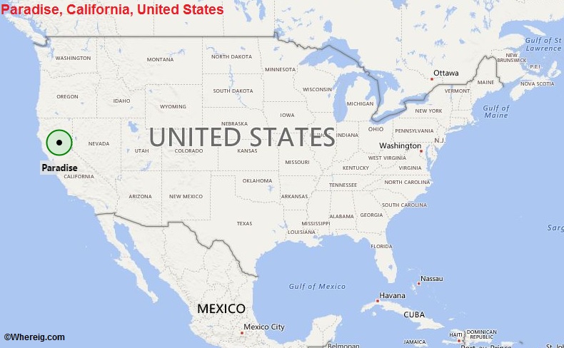
Paradise, California Quick Facts
| Fact | Details |
|---|---|
| City | Paradise |
| County | Butte County |
| State | California |
| State Capital | Sacramento |
| US Region | West |
| Latitude | 39.7596° N |
| Longitude | 121.6219° W |
| Elevation | 1,778 ft (542 m) |
| Land Area | 18.3 sq mi |
| Water Area | 0.0 sq mi |
| Total Area | 18.3 sq mi |
| Population (2020 Census) | 4,764 |
| Population Density | Approximately 260 per sq mi |
| ZIP Codes | 95967, 95969 |
| Area Code | 530 |
| Time Zone Standard | Pacific Standard Time (PST, UTC-8) |
| Time Zone Daylight | Pacific Daylight Time (PDT, UTC-7) |
| Currency | US Dollar (USD) |
| FIPS Code | 06-55520 |
| Congressional District | California 1st Congressional District |
Location and Surroundings
Paradise is located in Butte County on a ridge in the Sierra Nevada foothills of Northern California. It lies east of Chico and west of the Feather River Canyon, surrounded by forests and mountain landscapes. The town is known for its scenic setting, outdoor recreation opportunities, and its rebuilding efforts following the devastating Camp Fire of 2018.
Nearby Cities to Paradise, California
- Magalia, California - 6 mi North
- Chico, California - 12 mi West
- Oroville, California - 16 mi South
- Durham, California - 18 mi Southwest
- Gridley, California - 29 mi Southwest
- Willows, California - 38 mi West
- Yuba City, California - 53 mi South
- Marysville, California - 50 mi South
- Red Bluff, California - 42 mi Northwest
- Grass Valley, California - 63 mi Southeast
Paradise, California Climate and Weather Overview
| Month | Avg High (°F) | Avg Low (°F) | Avg Rainfall (in) |
|---|---|---|---|
| January | 53 | 37 | 6.4 |
| April | 69 | 45 | 2.3 |
| July | 92 | 61 | 0.1 |
| October | 78 | 52 | 1.5 |
| Annual | 73 | 49 | 33.0 |
| Climate Attribute | Details |
|---|---|
| Climate Classification (Köppen) | Hot-Summer Mediterranean (Csa) |
| Annual Rainfall | About 33 inches |
| Annual Sunshine Days | Approximately 255 days |
| Hurricane/Tornado Risk | Very low |
| Snowfall | Approximately 2-5 inches annually |
Driving Distances from Paradise, California
| City | State | Distance (mi) | Approx. Drive Time |
|---|---|---|---|
| Magalia | California | 6 | 10 min |
| Chico | California | 12 | 20 min |
| Oroville | California | 16 | 25 min |
| Durham | California | 18 | 30 min |
| Gridley | California | 29 | 40 min |
| Red Bluff | California | 42 | 55 min |
| Marysville | California | 50 | 1 hr |
| Yuba City | California | 53 | 1 hr 5 min |
| Grass Valley | California | 63 | 1 hr 20 min |
| Sacramento | California | 92 | 1 hr 45 min |
Transportation and Connectivity in Paradise, California
| Category | Details |
|---|---|
| Airport Name | Chico Regional Airport (nearest airport) |
| IATA Code | CIC |
| Port | Not Applicable |
| Major Highways | Skyway, Clark Road (CA 191), Neal Road |
| Train/Amtrak Service | Amtrak service available in nearby Chico |
| Local Bus/Transit Service | Butte Regional Transit (B-Line) |
- Skyway - Primary route connecting Paradise with Chico and the Sacramento Valley.
- Clark Road (State Route 191) - Major roadway linking Paradise with Oroville.
- Neal Road - Important evacuation and regional access route.
- Pentz Road - Connects residential neighborhoods throughout the town.
- Wagstaff Road - Serves eastern sections of Paradise and surrounding foothill areas.
- Concow Road - Provides access to nearby mountain communities.
Key Landmarks and Places to Visit in Paradise, California
| Landmark Name | Type |
|---|---|
| Paradise Community Park | Community Park |
| Paradise Memorial Trailway | Recreation Trail |
| Terry Ashe Recreation Center | Community Facility |
| Billie Park | Park |
| Paradise Lake | Natural Attraction |
| Honey Run Covered Bridge Area | Historic Site |
| Lake Oroville State Recreation Area | State Recreation Area |
| Butte Creek Canyon | Natural Attraction |
| Gold Nugget Museum | Museum |
| Bille Park Nature Trail | Nature Area |
Waterbodies in Paradise, California
Paradise Lake, Lake Oroville, Butte Creek, West Branch Feather River, Concow Creek, Little Butte Creek, Magalia Reservoir, Philbrook Reservoir, Feather River, De Sabla Reservoir
Golf Courses in Paradise, California
Paradise Pines Golf Course, Lake Oroville Golf and Event Center, Bidwell Park Golf Course, Canyon Oaks Country Club, Table Mountain Golf Course, Feather River Inn Golf Course, Sevillano Links, Butte Creek Country Club, Bailey Creek Golf Course, Gold Hills Golf Club
Economy and Major Employers in Paradise, California
| Sector | Major Employer or Industry | Notes |
|---|---|---|
| Healthcare | Adventist Health Feather River Services | Important healthcare provider in the region. |
| Construction | Residential Rebuilding Industry | Major economic activity following wildfire recovery. |
| Retail | Local Commercial Businesses | Supports community needs and employment. |
| Education | Paradise Unified School District | Key public-sector employer. |
| Government | Town of Paradise | Provides municipal services and jobs. |
| Tourism | Outdoor Recreation Industry | Benefits from nearby parks and lakes. |
| Professional Services | Local Service Businesses | Supports regional economic activity. |
| Agriculture | Foothill Farming Operations | Contributes to the local economy. |
Colleges and Schools in Paradise, California
| Institution Name | Type | Level | Notable For |
|---|---|---|---|
| Butte College | Public | Community College | Regional higher education provider |
| California State University, Chico | Public | University | Major university nearby |
| Paradise High School | Public | K-12 School | Historic local high school |
| Paradise Intermediate School | Public | K-12 School | Community education center |
| Paradise Unified School District | Public | K-12 District | Serves Paradise-area students |
| Achieve Charter School of Paradise | Public | K-12 School | Alternative education programs |
Paradise, California - Key Historical Facts
- Paradise was established in the late nineteenth century as a small mountain community in the Sierra Nevada foothills.
- The town developed around logging, ranching, and tourism activities that supported the regional economy.
- Paradise became a popular retirement and residential community because of its mild climate and scenic setting.
- The Camp Fire of November 2018 became the deadliest and most destructive wildfire in California history, devastating much of the town.
- Following the wildfire, residents and local leaders began extensive rebuilding and recovery efforts.
- Today, Paradise continues to rebuild while preserving its strong community identity and natural surroundings.
Sources
- Official Town of Paradise Website
- Official Butte County Website
- U.S. Census Bureau
- U.S. Geological Survey (USGS)
- National Weather Service
Most Viewed CA Maps
- Where is Los Angeles
- Where is San Diego
- Where is San Francisco
- Where is Anaheim
- Where is Bakersfield
- Where is Chula Vista
- Where is Freemont
- Where is Fresno
- Where is Glendale
- Where is Irvine
- Where is Long Beach
- Where is Modesto
- Where is Oakland
- Where is Paradise
- Where is Riverside
- Where is Sacramento
- Where is San Bernardino
- Where is San Jose
- Where is Santa Ana
- Where is Stockton
- Where is Berkeley
- Where is Clovis
- Where is Corona
- Where is Elk Grove
- Where is Escondido
- Where is Fontana
- Where is Fremont
- Where is Fullerton
- Where is Garden Grove
- Where is Hayward
- Where is Huntington Beach
- Where is Lancaster
- Where is Moreno Valley
- Where is Oceanside
- Where is Ontario
- Where is Orange
- Where is Oxnard
- Where is Palmdale
- Where is Pasadena
- Where is Pomona
- Where is Rancho Cucamonga
- Where is Roseville
- Where is Salinas
- Where is Santa Clara
- Where is Santa Clarita
- Where is Santa Rosa
- Where is Sunnyvale
- Where is Thousand Oaks
- Where is Torrance
- Where is Vallejo
- Where is Victorville
- Where is Visalia