
Where is Sunnyvale Located? - Sunnyvale is a city located in the Santa Clara County of California, United States. Sunnyvale lies between 37.2753 Degrees North latitudes and 107.8801 Degrees West longitudes.
Location Map of Sunnyvale, California
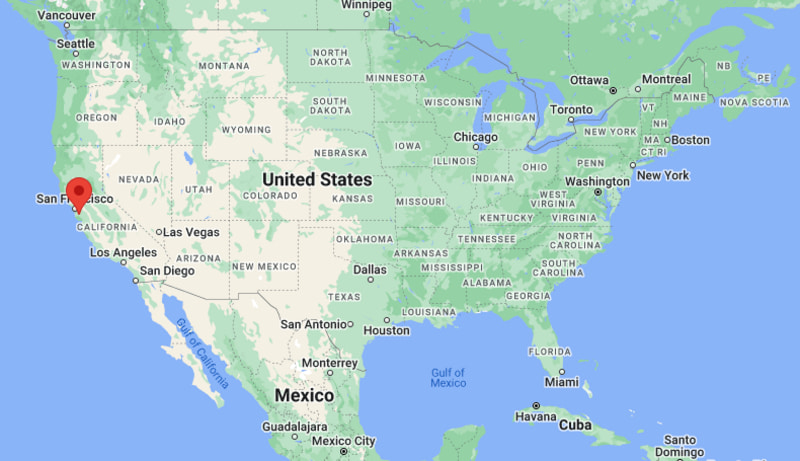
Sunnyvale Map, California, USA
Where is Sunnyvale?: The Google Map showing the location of Sunnyvale in the U.S. state of California.
Where is Sunnyvale Located?
Sunnyvale is a city located in the Santa Clara County of California, United States. Sunnyvale lies between 37.2753 Degrees North latitudes and 107.8801 Degrees West longitudes. According to 2020 U.S.census, the population of Sunnyvale city is 155805 people and the city has a total area of 22.03 sq mi. The city has numerous parks and recreational facilities.
Most Viewed US Maps
| USA Sttae Map | USA Region Map | USA Road Map |
| USA County Map | Where is USA in World Map? | US ZIP Code Map |
| USA Time Zones Map | US State and Capitals Map | USA Physical Map |
Find 4,400+ U.S. Cities by State - Explore Their Locations and Get Detailed Information
Sunnyvale, California Quick Facts
| Attribute | Details |
|---|---|
| City | Sunnyvale |
| County | Santa Clara County |
| State | California |
| State Capital | Sacramento |
| US Region | Western United States |
| Latitude | 37.3688° N |
| Longitude | 122.0363° W |
| Elevation | Approximately 82 ft (25 m) |
| Land Area (sq mi) | 22.97 |
| Water Area (sq mi) | 0.01 |
| Total Area (sq mi) | 22.98 |
| Population (2020 Census) | 155,805 |
| Population Density (per sq mi) | 6,782.6 |
| ZIP Codes | 94085, 94086, 94087, 94089 |
| Area Code | 408, 669 |
| Time Zone Standard | Pacific Standard Time (PST), UTC−8 |
| Time Zone Daylight | Pacific Daylight Time (PDT), UTC−7 |
| Currency | United States Dollar (USD) |
| FIPS Code | 0687700 |
| Congressional District | 16th Congressional District |
Transportation and Connectivity in Sunnyvale
| Transportation Feature | Details |
|---|---|
| Airport Name | Norman Y. Mineta San José International Airport provides commercial air service. |
| IATA Code | SJC |
| Port | No direct port access; nearby Port of Oakland and Port of San Francisco provide maritime connections. |
| Major Highways | U.S. Route 101, Interstate 280, State Route 237, and Central Expressway provide regional connections. |
| Train/Amtrak Service | Caltrain provides commuter rail service connecting Sunnyvale with San Jose and San Francisco. |
| Local Bus/Transit Service | Santa Clara Valley Transportation Authority (VTA) provides local bus and light rail services. |
- Sunnyvale is a city located in Santa Clara County, California.
- The city is located in the heart of Silicon Valley between San Jose and Mountain View.
- Sunnyvale is known for technology companies, business centers, parks, and its role in the global technology industry.
- The city developed from an agricultural community into a major technology and innovation hub.
Top Places to Visit in Sunnyvale, California
| Landmark Name | Type |
|---|---|
| Sunnyvale Heritage Park Museum | History Museum |
| Baylands Park | Regional Park |
| Las Palmas Park | Community Park |
| Ortega Park | Public Park |
| Sunnyvale Farmers' Market | Local Market |
| Murphy Avenue Historic District | Historic Downtown Area |
| Seven Seas Park | Family Recreation Park |
| Golfland USA Sunnyvale | Entertainment Center |
| Bay Trail Area | Outdoor Recreation Trail |
| Stevens Creek Trail | Walking and Cycling Trail |
Driving Distances from Sunnyvale, California to Nearby Cities
| City | State | Distance (mi) | Approx. Drive Time |
|---|---|---|---|
| Santa Clara | California | 5 | 10 min |
| San Jose | California | 12 | 20 min |
| Mountain View | California | 5 | 10 min |
| Palo Alto | California | 12 | 20 min |
| Fremont | California | 25 | 35 min |
| San Francisco | California | 45 | 1 hr |
| Oakland | California | 40 | 50 min |
| Sacramento | California | 120 | 2 hr |
| Monterey | California | 75 | 1 hr 30 min |
| Los Angeles | California | 350 | 5 hr 30 min |
Colleges and Universities near Sunnyvale, California
| Institution Name | Type | Level | Notable For |
|---|---|---|---|
| Santa Clara University | Private | University | Business, law, engineering, technology, and liberal arts programs |
| De Anza College | Public | Community College | Transfer programs, technology, business, and career education |
| Foothill College | Public | Community College | Science, technology, arts, and workforce programs |
| Stanford University | Private | University | Research, engineering, medicine, business, and innovation programs |
| San José State University | Public | University | Engineering, business, education, and technology programs |
Waterbodies near Sunnyvale, California
San Francisco Bay, Guadalupe River, Stevens Creek, Calabazas Creek, and nearby South Bay waterways
Golf Courses near Sunnyvale, California
Sunnyvale Municipal Golf Course, Palo Alto Hills Golf & Country Club, Shoreline Golf Links, and nearby Santa Clara Valley golf facilities
Key Landmarks and Places to Visit in Sunnyvale, California
| Landmark Name | Type |
|---|---|
| Sunnyvale Heritage Park Museum | History Museum |
| Baylands Park | Regional Park |
| Murphy Avenue Historic District | Historic Downtown Area |
| Sunnyvale Farmers' Market | Local Market |
| Las Palmas Park | Community Park |
| Ortega Park | Public Park |
| Seven Seas Park | Family Recreation Park |
| Stevens Creek Trail | Walking and Cycling Trail |
| Bay Trail Area | Outdoor Recreation Trail |
| Moffett Field Historical Area | Historic Aviation Site |
Waterbodies near Sunnyvale, California
San Francisco Bay, Guadalupe River, Stevens Creek, Calabazas Creek, and nearby South Bay waterways
Golf Courses near Sunnyvale, California
Sunnyvale Municipal Golf Course, Palo Alto Hills Golf & Country Club, Shoreline Golf Links, and nearby Santa Clara Valley golf facilities
Sunnyvale, California — Key Historical Facts
- Sunnyvale was originally an agricultural community known for fruit orchards, especially prunes and other crops.
- The city was incorporated in 1912 and gradually transformed from farming into an industrial and technology center.
- During World War II, Sunnyvale became connected to military and aerospace development through nearby Moffett Field.
- The city became a major part of Silicon Valley with the growth of electronics, semiconductor, and technology companies.
- Today, Sunnyvale is known for technology innovation, diverse neighborhoods, parks, and its central location in Silicon Valley.
References
- City of Sunnyvale Official Website
- Santa Clara County Government
- U.S. Census Bureau
- California Tourism
- Golden Gate National Recreation Area
- Santa Clara University
California Related Links
- Where is Los Angeles
- Where is San Diego
- Where is San Francisco
- Where is Anaheim
- Where is Bakersfield
- Where is Chula Vista
- Where is Freemont
- Where is Fresno
- Where is Glendale
- Where is Irvine
- Where is Long Beach
- Where is Modesto
- Where is Oakland
- Where is Paradise
- Where is Riverside
- Where is Sacramento
- Where is San Bernardino
- Where is San Jose
- Where is Santa Ana
- Where is Stockton
- Where is Berkeley
- Where is Clovis
- Where is Corona
- Where is Elk Grove
- Where is Escondido
- Where is Fontana
- Where is Fremont
- Where is Fullerton
- Where is Garden Grove
- Where is Hayward
- Where is Huntington Beach
- Where is Lancaster
- Where is Moreno Valley
- Where is Oceanside
- Where is Ontario
- Where is Orange
- Where is Oxnard
- Where is Palmdale
- Where is Pasadena
- Where is Pomona
- Where is Rancho Cucamonga
- Where is Roseville
- Where is Salinas
- Where is Santa Clara
- Where is Santa Clarita
- Where is Santa Rosa
- Where is Sunnyvale
- Where is Thousand Oaks
- Where is Torrance
- Where is Vallejo
- Where is Victorville
- Where is Visalia