
Where is Fremont Located? - Fremont is a city located in the Alameda County of California, United States. Fremont lies between 39.8083 Degrees North latitudes and 104.9339 Degrees West longitudes.
Location Map of Fremont, California
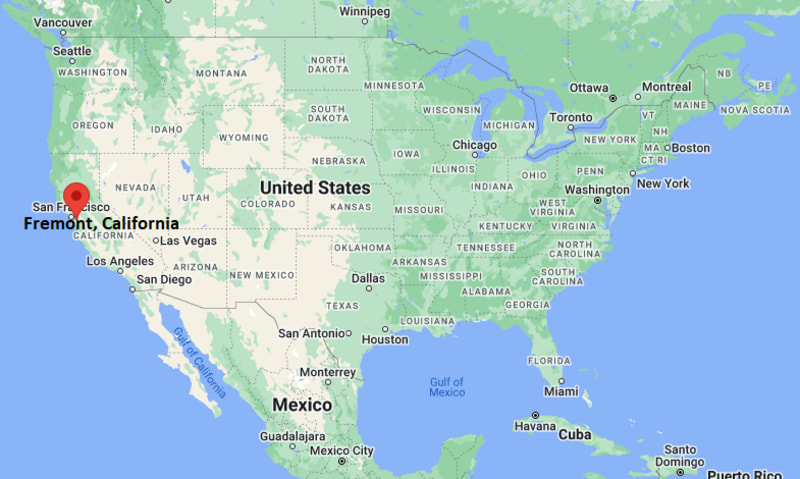
Fremont Map, California, USA
Where is Fremont?: The Google Map showing the location of Fremont in the U.S. state of California.
Where is Fremont Located?
Fremont is a city located in the Alameda County of California, United States. Fremont lies between 39.8083 Degrees North latitudes and 104.9339 Degrees West longitudes. According to 2020 U.S.census, the population of Fremont city is 230504 people and the city has a total area of 77.47 sq mi. The city has numerous parks and recreational facilities.
Most Viewed US Maps
| USA Sttae Map | USA Region Map | USA Road Map |
| USA County Map | Where is USA in World Map? | US ZIP Code Map |
| USA Time Zones Map | US State and Capitals Map | USA Physical Map |
Find 4,400+ U.S. Cities by State - Explore Their Locations and Get Detailed Information
Fremont City Facts California
| City | Fremont |
| State | California |
| Country | United States |
| County | Alameda County |
| Founded | 1956 |
| Incorporated | January 23, 1956 |
| Named After | John C. Frémont (American explorer) |
| Nickname | The Silicon Valley Gateway |
| Population (2025 estimate) | 232,000 |
| Total Area | 90.9 square miles |
| Elevation | 56 feet |
| Time Zone | Pacific Time (PT), UTC −8 (Standard), UTC −7 (Daylight Saving) |
| Latitude | 37.55° N |
| Longitude | 121.98° W |
| Coordinates | 37.55°N, 121.98°W |
| ZIP Codes | 94536, 94538, 94539, 94555 |
| Area Codes | 510, 341 |
| Official Language | English |
| Currency | United States Dollar (USD) |
| Major University | Ohlone College |
| Known For | Technology industry, cultural diversity, historic Mission San José |
| Climate | Mediterranean climate |
| Nearby Cities | Newark, Union City, Milpitas, San Jose |
| Main Attractions | Mission San José, Coyote Hills Regional Park, Ardenwood Historic Farm |
| Official Website | https://www.fremont.gov |
Nearby Cities to Fremont, California
- Newark, California - West - 4 mi
- Union City, California - Northwest - 6 mi
- Milpitas, California - South - 8 mi
- Hayward, California - Northwest - 15 mi
- Pleasanton, California - East - 18 mi
- Mountain View, California - Southwest - 17 mi
- Palo Alto, California - Southwest - 18 mi
- San Jose, California - South - 20 mi
- Sunnyvale, California - Southwest - 16 mi
- Oakland, California - Northwest - 34 mi
Driving Distances from Fremont, California
| City | State | Distance (mi) | Approx. Drive Time |
|---|---|---|---|
| Newark | California | 4 | 10 minutes |
| Union City | California | 6 | 12 minutes |
| Milpitas | California | 8 | 15 minutes |
| Sunnyvale | California | 16 | 22 minutes |
| Mountain View | California | 17 | 25 minutes |
| Palo Alto | California | 18 | 25 minutes |
| Pleasanton | California | 18 | 28 minutes |
| San Jose | California | 20 | 30 minutes |
| Hayward | California | 15 | 22 minutes |
| Oakland | California | 34 | 40 minutes |
Transportation and Connectivity in Fremont, California
| Mode | Details |
|---|---|
| Airport Name | Norman Y. Mineta San José International Airport (nearest major airport) |
| IATA Code | SJC |
| Port | Port of Oakland (nearby) |
| Major Highways | Interstate 680, Interstate 880, State Route 84, State Route 238 (nearby) |
| Train/Amtrak Service | BART (Fremont and Warm Springs/South Fremont stations); Amtrak Capitol Corridor nearby |
| Local Bus/Transit Service | AC Transit, Union City Transit, BART |
- Interstate 880 is the primary north-south freeway connecting Fremont with Oakland, Hayward, and San Jose.
- Interstate 680 links Fremont with Pleasanton, Walnut Creek, and California's inland communities.
- State Route 84 (Dumbarton Bridge) provides direct access across San Francisco Bay to Menlo Park and the Peninsula.
- State Route 238 offers convenient regional access to Hayward and surrounding East Bay communities.
What are top Places to Visit in Fremont, California
| Landmark Name | Type |
|---|---|
| Mission San José | Historic Site |
| Ardenwood Historic Farm | Historic Park |
| Coyote Hills Regional Park | Regional Park |
| Niles Historic District | Historic District |
| Aqua Adventure Waterpark | Water Park |
| Don Edwards San Francisco Bay National Wildlife Refuge | Wildlife Refuge |
| Central Park | City Park |
| Lake Elizabeth | Lake |
| Shinn Historical Park and Arboretum | Historic Park |
| Niles Essanay Silent Film Museum | Museum |
Colleges and Universities in Fremont, California
| Institution Name | Type | Level | Notable For |
|---|---|---|---|
| Ohlone College | Public | Community College | Transfer and career education |
| San Francisco Bay University | Private | University | STEM and business programs |
| California State University, East Bay | Public | University | Comprehensive undergraduate and graduate programs |
| Stanford University | Private | University | World-renowned research university |
| Fremont Unified School District | Public | K–12 District | Public education serving the city |
Waterbodies in Fremont, California
San Francisco Bay, Lake Elizabeth, Alameda Creek, Coyote Creek, Quarry Lakes, Don Edwards Marshes, Patterson Ranch Creek, Dry Creek
Golf Courses in Fremont, California
Mission Hills of Hayward Golf Course, Fremont Park Golf Club, Spring Valley Golf Course, Summitpointe Golf Club, Coyote Creek Golf Club, Sunol Valley Golf Club
Fremont, California — Key Historical Facts
- Fremont was incorporated in 1956 through the merger of the communities of Centerville, Irvington, Mission San José, Niles, and Warm Springs.
- Mission San José, founded in 1797, is one of California's historic Spanish missions and remains one of the city's most significant landmarks.
- The Niles District became an early center of the silent film industry, where Charlie Chaplin filmed several movies before Hollywood became the industry's hub.
- During the late twentieth century, Fremont emerged as a major technology and manufacturing center within Silicon Valley, attracting leading global companies.
- Today, Fremont is recognized for its diverse population, thriving technology sector, extensive park system, and strategic location between Silicon Valley and the East Bay.
References
California Related Links
- Where is Los Angeles
- Where is San Diego
- Where is San Francisco
- Where is Anaheim
- Where is Bakersfield
- Where is Chula Vista
- Where is Freemont
- Where is Fresno
- Where is Glendale
- Where is Irvine
- Where is Long Beach
- Where is Modesto
- Where is Oakland
- Where is Paradise
- Where is Riverside
- Where is Sacramento
- Where is San Bernardino
- Where is San Jose
- Where is Santa Ana
- Where is Stockton
- Where is Berkeley
- Where is Clovis
- Where is Corona
- Where is Elk Grove
- Where is Escondido
- Where is Fontana
- Where is Fremont
- Where is Fullerton
- Where is Garden Grove
- Where is Hayward
- Where is Huntington Beach
- Where is Lancaster
- Where is Moreno Valley
- Where is Oceanside
- Where is Ontario
- Where is Orange
- Where is Oxnard
- Where is Palmdale
- Where is Pasadena
- Where is Pomona
- Where is Rancho Cucamonga
- Where is Roseville
- Where is Salinas
- Where is Santa Clara
- Where is Santa Clarita
- Where is Santa Rosa
- Where is Sunnyvale
- Where is Thousand Oaks
- Where is Torrance
- Where is Vallejo
- Where is Victorville
- Where is Visalia