
Complete list of capital cities of the United States. The United States consists of 50 states, and each state has its own designated capital city. Washington, D.C. is the capital of the United States at the federal level. Below is an alphabetical list of U.S. state capitals.
United States Map with Capitals
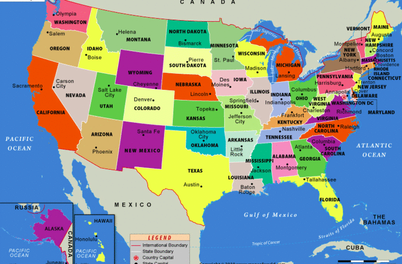 Image Credit to Mapsofworld.com
About Map - The map illustrates the capitals of all 50 states in the United States. The capital city of the United States of America is Washington, D.C., formally known as the District of Columbia and commonly referred to as D.C.
U.S. State Capitals
Below is a comprehensive alphabetical list of the capital cities of the United States, including their state abbreviation codes, official state nicknames, and the order in which each state was admitted to the Union. The United States consists of 50 states, each with its own capital city, serving as the political and administrative hub. Some well-known state capitals include Sacramento (California), Austin (Texas), Albany (New York) and Denver (Colorado). Washington, D.C., the federal capital, functions independently and serves as the political hub of the nation. State capitals often reflect the unique culture, history, and governance of their respective states, with many serving as historical landmarks. From Honolulu (Hawaii) in the Pacific to Juneau (Alaska) in the far north, these capitals represent the geographical and cultural diversity that defines the United States.
Capital Cities of the 50 U.S. States PDF
Download the complete PDF guide to the capital cities of all 50 U.S. states, including state capitals and state abbreviations.
List of U.S. State Capitals in Alphabetical Order
| State (Abbr.) | Capital | State Nickname | Became a State |
|---|---|---|---|
| Alabama (AL) | Montgomery | Heart of Dixie | December 14, 1819 |
| Alaska (AK) | Juneau | The Last Frontier | January 3, 1959 |
| Arizona (AZ) | Phoenix | Grand Canyon State | February 14, 1912 |
| Arkansas (AR) | Little Rock | The Natural State | June 15, 1836 |
| California (CA) | Sacramento | The Golden State | September 9, 1850 |
| Colorado (CO) | Denver | Centennial State | August 1, 1876 |
| Connecticut (CT) | Hartford | Constitution State | January 9, 1788 |
| Delaware (DE) | Dover | The First State | December 7, 1787 |
| Florida (FL) | Tallahassee | Sunshine State | March 3, 1845 |
| Georgia (GA) | Atlanta | Peach State | February 12, 1733 |
| Hawaii (HI) | Honolulu | Aloha State | August 21, 1959 |
| Idaho (ID) | Boise | Gem State | July 3, 1890 |
| Illinois (IL) | Springfield | Prairie State | December 3, 1818 |
| Indiana (IN) | Indianapolis | Hoosier State | December 11, 1816 |
| Iowa (IA) | Des Moines | Hawkeye State | December 28, 1846 |
| Kansas (KS) | Topeka | Sunflower State | January 29, 1861 |
| Kentucky (KY) | Frankfort | Bluegrass State | June 1, 1792 |
| Louisiana (LA) | Baton Rouge | Pelican State | April 30, 1812 |
| Maine (ME) | Augusta | Pine Tree State | March 15, 1820 |
| Maryland (MD) | Annapolis | Old Line State | April 28, 1788 |
| Massachusetts (MA) | Boston | The Bay State | February 6, 1788 |
| Michigan (MI) | Lansing | The Great Lakes State | January 26, 1837 |
| Minnesota (MN) | St. Paul | North Star State | May 11, 1858 |
| Mississippi (MS) | Jackson | Magnolia State | December 10, 1817 |
| Missouri (MO) | Jefferson City | Show-Me State | August 10, 1821 |
| Montana (MT) | Helena | Treasure State | November 8, 1889 |
| Nebraska (NE) | Lincoln | Cornhusker State | March 1, 1867 |
| Nevada (NV) | Carson City | Silver State | October 31, 1864 |
| New Hampshire (NH) | Concord | Granite State | June 21, 1788 |
| New Jersey (NJ) | Trenton | Garden State | December 18, 1787 |
| New Mexico (NM) | Santa Fe | Land of Enchantment | January 6, 1912 |
| New York (NY) | Albany | The Empire State | July 26, 1788 |
| North Carolina (NC) | Raleigh | First in Flight State | November 21, 1789 |
| North Dakota (ND) | Bismarck | Peace Garden State | November 2, 1889 |
| Ohio (OH) | Columbus | Buckeye State | March 1, 1803 |
| Oklahoma (OK) | Oklahoma City | Sooner State | November 16, 1907 |
| Oregon (OR) | Salem | Beaver State | February 14, 1859 |
| Pennsylvania (PA) | Harrisburg | Keystone State | December 12, 1787 |
| Rhode Island (RI) | Providence | Ocean State | May 29, 1790 |
| South Carolina (SC) | Columbia | Palmetto State | July 20, 1904 |
| South Dakota (SD) | Pierre | Mount Rushmore State | November 2, 1889 |
| Tennessee (TN) | Nashville | Volunteer State | June 1, 1796 |
| Texas (TX) | Austin | Lone Star State | December 29, 1845 |
| Utah (UT) | Salt Lake City | Beehive State | January 4, 1896 |
| Vermont (VT) | Montpelier | Green Mountain State | March 4, 1791 |
| Virginia (VA) | Richmond | The Old Dominion | June 25, 1788 |
| Washington (WA) | Olympia | Evergreen State | November 11, 1889 |
| West Virginia (WV) | Charleston | Mountain State | June 20, 1863 |
| Wisconsin (WI) | Madison | Badger State | May 29, 1848 |
| Wyoming (WY) | Cheyenne | Equality State | July 10, 1890 |
About United States Capitals
The US States and Capitals Map showing 48 contiguous states and their capitals, it also carries inset maps of two other states – Alaska and Hawaii. One of the most populated and powerful countries in the world, the United States of America is the third largest country, with a total land area of about 3,794,066 square miles (9,833,520 km2). The United States is situated between the Pacific and Atlantic Oceans, bordered by Canada to the north and Mexico to the south. The nation's capital is Washington DC.
The estimated population of the United States of America (USA) is 331,449,281 according to 2020 US census, the United States is also the third most populous country in the world. Almost 79% of the entire American population lives in urban areas. The New York City, Los Angeles, Chicago, Houston and Phoenix are the five most populated capital cities of the United States. While the United States is a diverse nation, the majority of Americans are descended from European immigrants, and African Americans are the largest minority group, followed by Asian Americans.
The United States is a federation of fifty states and one federal district, Washington, District of Colombia. Forty-eight of the fifty states make up the contiguous United States, and Alaska, while still part of the North American continent, is separated from the lower forty-eight by Canada. The fiftieth state, which entered the union most recently, is Hawaii, a chain of islands located in the Pacific Ocean.
The United States also possesses five major unincorporated overseas territories: Puerto Rico and the United States Virgin Islands in the Caribbean, American Samoa, Northern Mariana, and the Islands in the Pacific.
World Countries and Capitals
- Where is Akron
- Where is Anaheim
- Where is Anchorage
- Where is Arlington
- Where is Aurora
- Where is Baltimore
- Where is Baton Rouge
- Where is Birmingham
- Where is Boise City
- Where is Boston
- Where is Buffalo
- Where is Chandler
- Where is Charlotte
- Where is Chesapeake
- Where is Chula Vista
- Where is Cincinnati
- Where is Cleveland
- Where is Colorado Springs
- Where is Columbus
- Where is Corpus Christi
- Where is Des Moines
- Where is Detroit
- Where is Durham
- Where is El Paso
- Where is Fayetteville
- Where is Fort Wayne
- Where is Freemont
- Where is Fresno
- Where is Garland
- Where is Gilbert
- Where is Glendale
- Where is Greensboro
- Where is Henderson
- Where is Hialeah
- Where is Honolulu
- Where is Houston
- Where is Indianapolis
- Where is Irvine
- Where is Irving
- Where is Jacksonville
- Where is Jersey City
- Where is Kansas City
- Where is Laredo
- Where is Lincoln
- Where is Long Beach
- Where is Louisville
- Where is Lubbock
- Where is Madison
- Where is Memphis
- Where is Mesa
- Where is Milwaukee
- Where is Minneapolis
- Where is Modesto
- Where is Montgomery
- Where is Nashville
- Where is Newark
- Where is Norfolk
- Where is North Las Vegas
- Where is Oakland
- Where is Oklahoma City
- Where is Omaha
- Where is Orlando
- Where is Paradise
- Where is Philadelphia
- Where is Phoenix
- Where is Portland
- Where is Raleigh
- Where is Reno
- Where is Richmond
- Where is Riverside
- Where is Rochester
- Where is Sacramento
- Where is Saint Paul
- Where is Saint Petersburg
- Where is San Bernardino
- Where is San Jose
- Where is Santa Ana
- Where is Scottsdale
- Where is Shreveport
- Where is Spokane
- Where is St Louis
- Where is Stockton
- Where is Tampa
- Where is Toledo
- Where is Tucson
- Where is Tulsa
- Where is Virginia Beach
- Where is Wichita