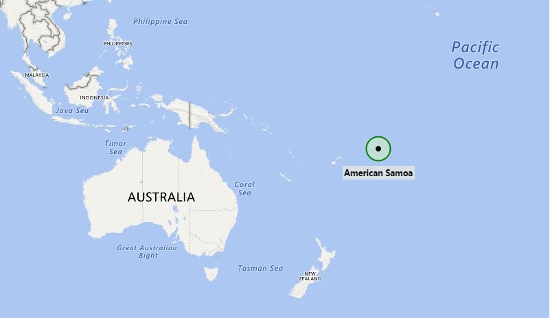
American Samoa is an unincorporated territory of the United States located in the South Pacific Ocean, southeast of Samoa.
Tsunami observed in American Samoa after Tonga volcano erupts
Location Map of American Samoa

Where is American Samoa Located?
American Samoa a group of islands in the South Pacific Ocean, about half way between Hawaii and New Zealand.
The main (largest and most populous) island is Tutuila, with the Manua Islands, Rose Atoll, and Swains Island also included in the territory. Fire dance is a traditional dance. American Samoa is the southernmost territory of the United States.In total there are 24 cities. The beautiful city of Pago Pago (the capital), has a magnificent harbor ringed by densely forested mountains. The outer islands are widely considered some of the most beautiful in the South Pacific
Places to see in American Samoa:
| National Park of American Samoa | Polu island, Vatia | Swains Island Lagoon | Fagasa Bay |
| Fagaalu Bay | National Marine Sanctuary | Fagatogo, Pago Pago | Lata Mountain |
| Aua Church | Fatu Rock | Larson Beach | Olosega |
| Mount Alava | Flowerpot | Aunu'u | World War II heritage Trail |
| Jean P Haydon Museum | Pago Pago Harbour | Ofu | Vai'ava Strait National Natural |
| Fagatele Marine Sanctuary | Rainmaker Mountain | Pola Island |
Facts about American Samoa
| Official Name | Territory of American Samoa |
| Short form | American Samoa |
| Abbreviation of American Samoa | AS |
| ISO Country Code | AS, ASM |
| Sovereign state | United States |
| Continent | Oceania |
| Coordinates | 14.2710° S, 170.1322° W |
| Capital of American Samoa | Pago Pago |
| Five volcanic islands | Tutuila, Aunu'u, Ofu, Olosega, and Ta'ū |
| Two Atolls | Swains and Rose Atoll |
| Area | 77 sq mi (200 km2) |
| Population | 55,212 (208th) |
| Religion | 98.3% Christian 1.7% other |
| Official languages | Samoan, English |
| Country Dialing Code | 684 |
| Time Zone | UTC-11:00 (SST) |
| American Samoa Climate | Tropical climate |
| Independency Day | 15 April |
| Government | Devolved presidential constitutional dependency |
| Calling code | -683 |
| Internet TLD | .as |
- Where is American Samoa
- Where is Ashmore and Cartier Islands
- Where is Australia
- Where is Cook Islands
- Where is Coral Sea Islands
- Where is Micronesia
- Where is Fiji
- Where is French Polynesia
- Where is Guam
- Where is Kiribati
- Where is Marshall Islands
- Where is Nauru
- Where is New Caledonia
- Where is New Zealand
- Where is Niue
- Where is Norfolk Island
- Where is Northern Mariana Islands
- Where is Palau
- Where is Palmyra Atoll
- Where is Papua New Guinea
- Where is Paracel Islands
- Where is Pitcairn Islands
- Where is Samoa
- Where is Solomon Islands
- Where is Tokelau
- Where is Tonga
- Where is Tuvalu
- Where is Vanuatu
- Where is Wake Island
- Where is Wallis and Futuna
