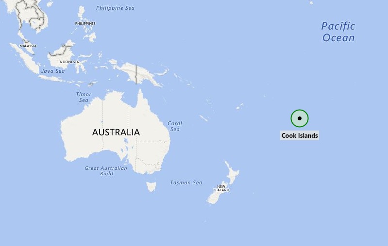
Cook Islands, self-governing island country, located in the South Pacific Ocean in free association with New Zealand.
Location Map of Cook Islands

Where is Cook Islands Located?
The given Cook Islands location map shows that Cook Islands are located in the South Pacific Ocean.
Cook Islands map also shows that the region is a group of Islands which earlier were under the sovereignty of New Zealand but in the year 1992 it got its independence and most of the ministries now governed by local rulers.
However, defense and foreign affairs are the accountability of New Zealand, after consultation with the Cook Islands. In recent times, the Cook Islands have been gradually adopting an increasingly self-determining foreign policy and taking own decisions. Though Cook Islanders are the citizens of New Zealand; besides, they have the status of Cook Islands nationals, which is not available with all New Zealand citizens. Geographically, the Cook Islands are located in the South Pacific Ocean, exactly north-east of New Zealand and between French Polynesia and American Samoa. The country consists of about fifteen most important islands; which are divided into two separate groups: the Southern Cook Islands, and the Northern Cook Islands of coral atolls.
The main source of revenue of the country is tourism. The islands have mild climate and several picturesque landscapes that attract tourists across the world. Thousands of tourists from different part of the world visit these islands every year. The other source of county's income is offshore banking, pearls, marine, and fruit exports.Places to see in Cook Islands:
| Muri Beach | Te Vara Nui Village | Pukapuka | Southern Cook Islands |
| Tapuaetai | Ootu Beach | Manuae | Aroa Beach |
| Punanga Nui Market | Rakahanga | Te Rua Manga | Akaiami |
| Akitua | Takutea | One Foot Island | Muri Night Markets |
| Moturakau | Highland Paradise | Titikaveka Beach | Northern Cook Islands |
| Maungap | Paradise Cove | Wigmore's Waterfall | Sokala Villas - Private Beachside |
Facts about Cook Islands
| Official Name | Cook Islands |
| Coordinates | 21.2367° S, 159.7777° W |
| Capital City | Avarua |
| Largest city | Avarua |
| Official Language | English, Cook Islands Māori |
| Government | Constitutional Monarchy |
| Area | 236.7 km2 (91.4 sq mi) |
| Population | 19,600 |
| Ethnic Groups | Maori 87.7%, part Maori 5.8%, other 6.5% |
| Legislature | Parliament |
| Currency | New Zealand dollar (NZD) Cook Islands dollar |
| Time Zone | UTC-10 (CKT) |
| ISO Code | CK |
| Calling Code | 682 |
| Independence Day | 1992 |
| ISO 3166 code | CK |
| Internet TLD | .ck |
- Where is American Samoa
- Where is Ashmore and Cartier Islands
- Where is Australia
- Where is Cook Islands
- Where is Coral Sea Islands
- Where is Micronesia
- Where is Fiji
- Where is French Polynesia
- Where is Guam
- Where is Kiribati
- Where is Marshall Islands
- Where is Nauru
- Where is New Caledonia
- Where is New Zealand
- Where is Niue
- Where is Norfolk Island
- Where is Northern Mariana Islands
- Where is Palau
- Where is Palmyra Atoll
- Where is Papua New Guinea
- Where is Paracel Islands
- Where is Pitcairn Islands
- Where is Samoa
- Where is Solomon Islands
- Where is Tokelau
- Where is Tonga
- Where is Tuvalu
- Where is Vanuatu
- Where is Wake Island
- Where is Wallis and Futuna
