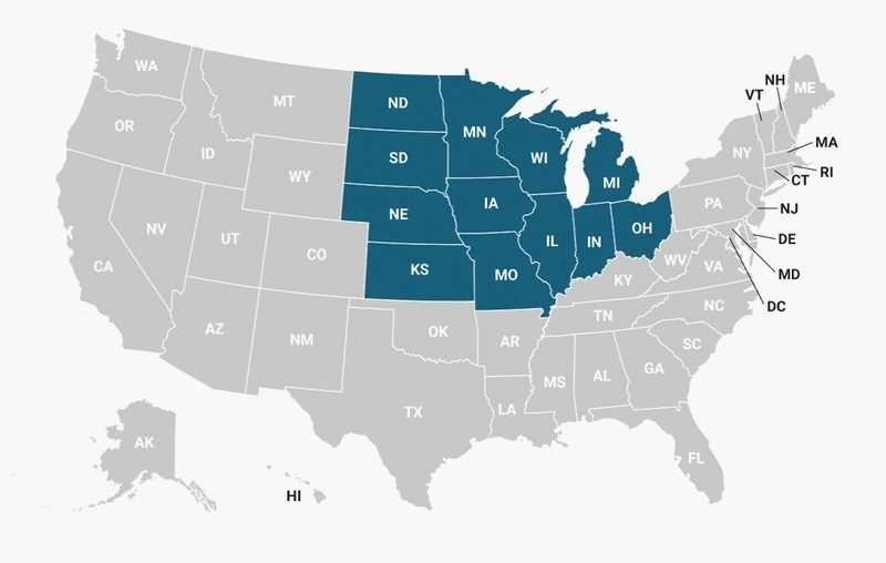
This is List of Midwestern United States: and their 2020 estimate population, area and largest city.
Map of Midwest USA States
 About Map - Map showing Midwestern United States.
Midwestern United States
The Midwestern United States consists of 12 states in the north central United States: Illinois, Indiana, Iowa, Kansas, Michigan, Minnesota, Missouri, Nebraska, North Dakota, Ohio, South Dakota, and Wisconsin. It is one of four census regions of the U.S. Census Bureau. Popular cities in Midwest States are Chicago, Columbus, Indianapolis, Detroit, Milwaukee, Kansas City, Minneapolis, Wichita, Omaha, St. Paul, Cleveland and St. Louis.
The Midwestern United States is one of the four census regions recognized by the United States Census Bureau. It is also known as the Midwest or the American Midwest or Second Region. The Census Bureau referred to it as the North Central Region until 1984. The Midwestern United States is situated between the Northeastern and Western US, with Canada to the north and the South US to the south. The area is often located on the vast Interior Plain between the states that are part of the Rocky Mountain range and the states that are part of the Appalachian Mountain range. The Ohio River, Upper Mississippi River, and Missouri River are a few of the region's major rivers, running east to west.
The Census Bureau has divided the Midwestern United States into two regions. The first division is the East North Central Division. Illinois, Indiana, Michigan, Ohio, and Wisconsin are all included in the East North Central Division and are all a part of the Great Lakes region. The second division is the West North Central Division, which includes 7 states namely Iowa, Kansas, Minnesota, Missouri, North Dakota, Nebraska, and South Dakota. These states are situated, at least to some extent, in the Great Plains. Economically, the Midwestern United States is balanced between heavy industry and agriculture. Significant portions of this region make up the Corn Belt of the United States, while banking and other services like healthcare and education are becoming more significant. Illinois is the most populous state in the Midwestern United States with 12,812,508. The second place goes to Indiana with 6,732,219 population of 6,732,219.
The map of the Midwestern United States indicates all these 12 states, which are located in this region. Can you locate them in the Map of Midwest States that is provided on this page? If you want to download the Midwestern United States Map, you can do so and we are not charging even a penny for that
Most Viewd Links
List of States is Midwestern United States
| State | Population 2020 Estimate | Area | Density | Largest City |
|---|---|---|---|---|
| Illinois | 12,812,508 | 55,518.89 sq mi (143,793.3 sq Km) | 231/sq mi (89/sq Km) | Chicago |
| Indiana | 6,732,219 | 35,826.08 sq mi (92,789.1 sq Km) | 186/sq mi (72/sq Km) | Indianapolis |
| Iowa | 3,155,070 | 55,857.09 sq mi (144,669.2 sq Km) | 56/sq mi (22/sq Km) | Des Moines |
| Kansas | 2,937,880 | 81,758.65 sq mi (211,753.9 sq Km) | 36/sq mi (14/sq Km) | Wichita |
| Michigan | 10,077,331 | 56,538.86 sq mi (146,435.0 sq Km) | 176/sq mi (68/sq Km) | Detroit |
| Minnesota | 5,706,494 | 79,626.68 sq mi (206,232.2 sq Km) | 70/sq mi (27/sq Km) | Minneapolis St. Paul |
| Missouri | 6,154,913 | 68,741.47 sq mi (178,039.6 sq Km) | 89/sq mi (34/sq Km) | Kansas City St. Louis |
| Nebraska | 1,961,504 | 76,824.11 sq mi (198,973.5 sq Km) | 25/sq mi (10/sq Km) | Omaha |
| North Dakota | 779,094 | 69,000.74 sq mi (178,711.1 sq Km) | 11/sq mi (4/sq Km) | Fargo |
| Ohio | 11,799,448 | 40,860.66 sq mi (105,828.6 sq Km) | 285/sq mi (110/sq Km) | Columbus Cleveland |
| South Dakota | 886,667 | 75,810.94 sq mi (196,349.4 sq Km) | 11/sq mi (4/sq Km) | Sioux Falls |
| Wisconsin | 5,893,718 | 54,157.76 sq mi (140,268.0 sq Km) | 107/sq mi (41/sq Km) | Milwaukee |
| Total | 68,896,846 | 750,521.93 sq mi (1,943,842.9 sq Km) | 91/sq mi (35/sq Km |
