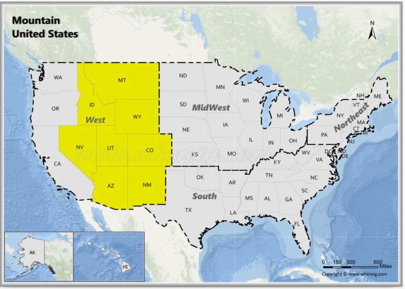
The Mountain States of the United States, also known as the Mountain West, are a group of states located in the western part of the country. The Mountain States include eight states: Arizona, Colorado, Idaho, Montana, Nevada, New Mexico, Utah and Wyoming The Mountain region, is one of the nine Census Bureau Divisions of the United States. The region features stunning landscapes, including the Rocky Mountains, deserts, plateaus, and canyons. It is home to famous natural landmarks such as the Grand Canyon in Arizona, Yellowstone National Park in Wyoming, and Zion National Park in Utah.
Map of Mountain States, USA
 About Map - Map showing Mountain United States.
Mountain States, USA
One of the nine geographical divisions of the United States recognized by the United States Census Bureau is the Mountain States, commonly referred to as the Mountain West or the Interior West. It belongs to the Western United States as a sub region. The term "mountain states" refers to the United States in general. States that are surrounded by the United States Rocky Mountains are called Mountain States. Mountain States of USA are eight in number and they are Arizona, Colorado, Idaho, Montana, Nevada, New Mexico, Utah, and Wyoming. These are considered Mountain states. West River, South Dakota is occasionally included. The combined land area of the eight states is approximately 855,767 square miles (2,216,426 square kilometers). With Utah, Idaho, Nevada, Colorado, and Arizona among the states with the strongest growth rates, it is the area of the country that is expanding the quickest./
The region of Mountain States has two subdivisions, which are known as Northwest and Southwest. The Northwest region of Mountain West consists of three states namely Idaho, Wyoming, and Montana. The Southwest region of Mountain West comprises Arizona, Colorado, Nevada, New Mexico, and Utah. The Rocky Mountain Range is the most significant mountain range in the Mountain States along with the others. The population of the Mountain States is about 25 million. Wyoming has the least population among the Mountain States, whereas Arizona has the largest. Mountain States can be ranked by highest elevation. Colorado is in first position as it has Mount Elbert with a height of 4401 meters. Wyoming is in the second position with Gannett Peak, which is around 4209 meters. Wyoming is followed by Utah, New Mexico, Nevada, Montana and Idaho. Arizona is in the last position as its Humphreys Peak is just 3852 meters.
The Mountainern United States consists of eight states: Arizona, Colorado, Idaho, Montana, Nevada, New Mexico, Utah, and Wyoming. Popular cities in the Mountain States are Phoenix, Denver, Las Vegas, Salt Lake City, Boise, Billings, Tucson, Albuquerque and Cheyenne.
List of Mountainern United States with Capitals
| State | Capital | Major Cities | Populaion 2020 Census | Land Area (Sq mi) | Density (Sq mi) | Total County |
|---|---|---|---|---|---|---|
| Arizona | Phoenix | Phoenix, Tucson, Mesa, Chandler and Glendale | 7,151,502 | 113,594 sq mi (294,207 km2) | 59.3 | 15 |
| Colorado | Denver | Denver, Colorado Springs, Aurora, Fort Collins and Lakewood | 5,773,714 | 103,642 sq mi (268,431 km2) | 51.7 | 64 |
| Idaho | Boise | Boise, Nampa, Meridian, Idaho Falls and Pocatello | 1,839,106 | 82,643 sq mi (214,045 km2) | 19.8 | 44 |
| Montana | Helena | Billings, Missoula, Great Falls, Bozeman and Butte, Helena | 1,084,225 | 145,546 sq mi (376,962 km2) | 7 | 56 |
| Nevada | Carson City | Las Vegas, Henderson, North Las Vegas, Reno, Sparks and Carson City | 3,104,614 | 109,781 sq mi (284,332 km2) | 25.9 | 17 |
| New Mexico | Santa Fe | Albuquerque, Las Cruces, Rio Rancho, Santa Fe and Roswell | 2,117,522 | 121,298 sq mi (314,161 km2) | 17.2 | 33 |
| Utah | Salt Lake City | Salt Lake City, West Valley City, Provo, West Jordan and Orem | 3,271,616 | 82,170 sq mi (212,818 km2) | 35.8 | 29 |
| Wyoming | Cheyenne | Cheyenne, Casper, Laramie, Gillette and Rock Springs | 576,851 | 97,093 sq mi (251,470 km2) | 6 | 23 |
U.S. Mountain West Facts
| Region Name | Mountain States (Mountain West) |
| Country | United States of America |
| U.S. Census Classification | West - Mountain Division |
| States Included | Arizona, Colorado, Idaho, Montana, Nevada, New Mexico, Utah, Wyoming |
| Number of States | 8 |
| Total Population (2025 est.) | 27-29 million |
| Total Area | 855,000 sq mi (2.21 million km²) |
| Most Populous State | Arizona |
| Largest City | Phoenix, Arizona |
| Major Cities | Phoenix, Denver, Las Vegas, Salt Lake City, Boise, Albuquerque, Reno |
| Capital Cities | Phoenix, Denver, Boise, Helena, Carson City, Santa Fe, Salt Lake City, Cheyenne |
| Climate | Arid and semi-arid deserts, alpine climate in mountains, cold winters at high elevations |
| Major Mountain Ranges | Rocky Mountains, Sierra Nevada, Wasatch Range, Bitterroot Range |
| Major Rivers | Colorado River, Snake River, Rio Grande, Green River |
| Economic Profile | Tourism, mining, energy, technology, agriculture, outdoor recreation |
| Cultural Significance | Native American heritage, frontier history, outdoor lifestyle, national parks |
| Major Tourist Attractions | Grand Canyon, Yellowstone National Park, Rocky Mountain National Park, Zion National Park, Bryce Canyon, Arches National Park, Lake Tahoe |
| Time Zones | UTC -6 (Mountain Time), UTC -7 (Mountain Standard Time - no DST in parts) |
| Famous For | National parks, deserts, mountains, outdoor adventure, scenic landscapes |
