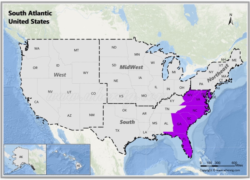
The South Atlantic region, is one of the nine Census Bureau Divisions of the United States.
Map of South Atlantic States, USA
 About Map - Map showing South Atlantic United States.
The South Atlanticern United States consists of nine states: Delaware; Florida; Georgia; Maryland; North Carolina; South Carolina; Virginia; Washington, D.C. and West Virginia. Popular cities in the South Atlantic region are Washington DC, Dover, Miami, Tallahassee, Atlanta, Baltimore, Charlotte, Columbia, Richmond and Charleston.
Most Viewd Links
List of South Atlantic United States with Capitals
| State | Capital | Major Cities | Populaion 2020 Census | Land Area (Sq mi) | Density (Sq mi) | Total County |
|---|---|---|---|---|---|---|
| Delaware | Dover | Wilmington, Dover, Newark, Middletown and Smyrna | 989,948 | 1,949 sq mi (5,047 km2) | 480.1 | 3 |
| District Of Columbia | #N/A | #N/A | 689,545 | 61 sq mi (158 km2) | 10,801.50 | 1 |
| Florida | Tallahassee | Jacksonville, Miami, Tampa, St. Petersburg, Orlando and Tallahassee | 21,538,187 | 53,625 sq mi (138,887 km2) | 371 | 67 |
| Georgia | Atlanta | Atlanta, Augusta-Richmond, Columbus, Savannah and Athens | 10,711,908 | 57,513 sq mi (148,959 km2) | 175.6 | 159 |
| Maryland | Annapolis | Baltimore, Frederick, Rockville, Gaithersburg, Bowie and Annapolis | 6,177,224 | 9,707 sq mi (25,142 km2) | 615.7 | 24 |
| North Carolina | Raleigh | Charlotte, Raleigh, Greensboro, Winston-Salem and Durham | 10,439,388 | 48,618 sq mi (125,920 km2) | 204.5 | 100 |
| South Carolina | Columbia | Columbia, Charleston, North Charleston, Mount Pleasant and Rock Hill | 5,118,425 | 30,061 sq mi (77,857 km2) | 160.8 | 46 |
| Virginia | Richmond | Virginia Beach, Norfolk, Chesapeake, Richmond and Newport News | 8,631,393 | 39,490 sq mi (102,279 km2) | 210.8 | 133 |
| West Virginia | Charleston | Charleston, Huntington, Parkersburg, Morgantown and Wheeling | 1,793,716 | 24,038 sq mi (62,259 km2) | 77 | 55 |
South Atlantic States, United States Facts
| Region Name | South Atlantic States |
| Country | United States of America |
| U.S. Census Classification | South - South Atlantic Division |
| States & District Included | Delaware, Florida, Georgia, Maryland, North Carolina, South Carolina, Virginia, West Virginia, Washington, D.C. |
| Number of States/Territories | 9 |
| Total Population (2025 est.) | 70-73 million |
| Total Area | 292,000 sq mi (756,000 sq km) |
| Most Populous State | Florida |
| Largest City | Jacksonville, Florida |
| Major Cities | Miami, Orlando, Tampa, Atlanta, Charlotte, Raleigh, Richmond, Charleston, Wilmington |
| Capital Cities | Dover, Tallahassee, Atlanta, Annapolis, Raleigh, Columbia, Richmond, Charleston, Washington, D.C. |
| Climate | Humid subtropical; tropical in southern Florida; mountainous climate in Appalachians |
| Major Rivers | Potomac River, Savannah River, James River, Roanoke River |
| Major Water Bodies | Atlantic Ocean, Chesapeake Bay |
| Economic Profile | Tourism, defense, agriculture, ports and trade, technology, finance |
| Cultural Significance | Colonial history, Civil Rights movement, coastal culture, Appalachian heritage |
| Major Tourist Attractions | Walt Disney World, Everglades National Park, Great Smoky Mountains, Outer Banks, Charleston Historic District, Virginia Beach |
| Time Zones | UTC -5 (Eastern Time) |
| Famous For | Beaches, theme parks, historic cities, barrier islands, warm climate |
