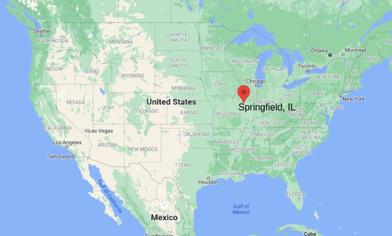
Interesting Facts about Springfield
Country: United States of America
State: Illinois
County: Sangamon
Area: 156 km2
Population (metro): 208,182 (2010)
Climate: Humid Continental Climate
Most of the administrative bodies are centred on the city Springfield. Surprisingly, the economy of city is largely depends upon government jobs. The city largely situated in a plain region nearby Lake Springfield and Sangamon River; the Lake Springfield is a huge artificial important lake because it provides drinking water and the lake is administered by City Water, Light & Power Company. Besides, it is also important centre for the recreation.
The capital city has also major tourist's attractions in the region; the major tourist's points in the city are historic sites memorizing Lincoln, lake, and various other centres listed below:
- Lincoln Home National Historic Site
- National Historical Park
- Lincoln-Herndon Law Offices State Historic Site
- Lincoln Tomb State Historic Site
- Old State Capitol State Historic Site
- Abraham Lincoln Presidential Library and Museum
- Knights Action Park
- Caribbean Water Park
More Illinois Maps & Info
US Cities Location
- Where is Akron
- Where is Anaheim
- Where is Anchorage
- Where is Arlington
- Where is Aurora
- Where is Baltimore
- Where is Baton Rouge
- Where is Birmingham
- Where is Boise City
- Where is Boston
- Where is Buffalo
- Where is Chandler
- Where is Charlotte
- Where is Chesapeake
- Where is Chula Vista
- Where is Cincinnati
- Where is Cleveland
- Where is Colorado Springs
- Where is Columbus
- Where is Corpus Christi
- Where is Des Moines
- Where is Detroit
- Where is Durham
- Where is El Paso
- Where is Fayetteville
- Where is Fort Wayne
- Where is Freemont
- Where is Fresno
- Where is Garland
- Where is Gilbert
- Where is Glendale
- Where is Greensboro
- Where is Henderson
- Where is Hialeah
- Where is Honolulu
- Where is Houston
- Where is Indianapolis
- Where is Irvine
- Where is Irving
- Where is Jacksonville
- Where is Jersey City
- Where is Kansas City
- Where is Laredo
- Where is Lincoln
- Where is Long Beach
- Where is Louisville
- Where is Lubbock
- Where is Madison
- Where is Memphis
- Where is Mesa
- Where is Milwaukee
- Where is Minneapolis
- Where is Modesto
- Where is Montgomery
- Where is Nashville
- Where is Newark
- Where is Norfolk
- North Las Vegas
- Oakland
- Oklahoma City
- Where is Omaha
- Where is Orlando
- Where is Paradise
- Where is Philadelphia
- Where is Phoenix
- Where is Portland
- Where is Raleigh
- Where is Reno
- Where is Richmond
- Where is Riverside
- Where is Rochester
- Where is Sacramento
- Where is Saint Paul
- Where is Saint Petersburg
- Where is San Bernardino
- Where is San Jose
- Where is Santa Ana
- Where is Scottsdale
- Where is Shreveport
- Where is Spokane
- Where is St Louis
- Where is Stockton
- Where is Tampa
- Where is Toledo
- Where is Tucson
- Where is Tulsa
- Where is Virginia Beach
- Where is Wichita
| (adsbygoogle = window.adsbygoogle || []).push({}); |


