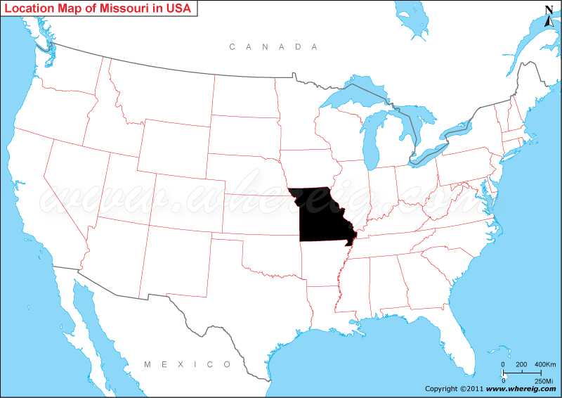
The given Missouri location map shows that Missouri is located in the mid-western part of the US. Missouri map also shows that Missouri shares its state border with Illinois in the east, Iowa in the north, Nebraska in the north-west, Kansas in the west, Oklahoma in the south-west, Arkansas in the south, and Tennessee in the south-east.
Missouri Location Map
 About Map: Map showing location of Missouri in the US Map.
Other Missouri Maps & Info
Where is Missouri Located?
TMissouri is a state in the Midwestern region of the United States bordered by Arkansas, Illinois, Iowa, Kentucky, Kansas, Nebraska, Oklahoma and Tennessee. The latitude of Missouri 38.573936 , and the longitude is -92.603760.
Jefferson City is the capital of Missouri. In fact, Missouri was originally the part of France and it has been purchased from France and then defined as the Missouri Territory. However, after remaining as the Part of the Missouri Territory has admitted into the union as the 24th state on August 10, 1821.
Interestingly, it has both Midwestern and Southern cultural influences that reflects its history as a border state. Furthermore, it is also a transition between the Eastern and Western United States; St. Louis city is often called as "western-most Eastern city" and Kansas City as eastern-most Western city.
St. Louis city is located nearby the confluence of the Mississippi and Missouri rivers. In addition, the mean center of United States population is currently in Missouri. The climate type of Missouri is humid continental climate.
Some of the important cities of Missouri are St. Louis, Kansas City, Springfield, and Columbia.
Top 20 Cities of Missouri by Population
| City | County | Population (2019) | City | County | Population (2019) |
|---|---|---|---|---|---|
| Kansas City | Jackson, Platte, Cass, Clay | 495,327 | Blue Springs | Jackson | 55,829 |
| St. Louis | independent city | 300,576 | Florissant | St. Louis | 50,952 |
| Springfield | Greene | 167,882 | Joplin | Jasper, Newton | 50,925 |
| Columbia | Boone | 123,195 | Chesterfield | St. Louis | 47,538 |
| Independence | Jackson | 116,672 | Jefferson City | Cole | 42,708 |
| Lee's Summit | Jackson | 99,357 | Wentzville | St. Charles | 41,784 |
| O'Fallon | St. Charles | 88,673 | Cape Girardeau | Cape Girardeau | 40,559 |
| St. Joseph | Buchanan | 74,875 | Wildwood | St. Louis | 35,432 |
| St. Charles | St. Charles | 71,028 | University City | St. Louis | 34,165 |
| St. Peters | St. Charles | 58,212 | Liberty | Clay | 32,100 |
Missouri State Facts
| Continent: | North America |
| Country: | United States |
| Coordinates | 37.9643° N, 91.8318° W |
| Region Type: | State |
| Capital: | Jefferson City |
| Abbreviation: | MO, US-MO |
| Largest City: | Kansas City |
| Area: | 69,709 sq mi (180,533 km2) |
| Population: | 6,154,913 (2020 Census) |
| Joined The Union: | August 10, 1821 (24th) |
| Nickname: | Show-Me State |
| Highest Point: | Taum Sauk Mountain |
| Lowest Point: | Saint Francis River at southern Arkansas border |
| Timezone: | Central: UTC −6/−5 |
| Official Website: | https://www.mo.gov/ |
- Where is Akron
- Where is Anaheim
- Where is Anchorage
- Where is Arlington
- Where is Aurora
- Where is Baltimore
- Where is Baton Rouge
- Where is Birmingham
- Where is Boise City
- Where is Boston
- Where is Buffalo
- Where is Chandler
- Where is Charlotte
- Where is Chesapeake
- Where is Chula Vista
- Where is Cincinnati
- Where is Cleveland
- Where is Colorado Springs
- Where is Columbus
- Where is Corpus Christi
- Where is Des Moines
- Where is Detroit
- Where is Durham
- Where is El Paso
- Where is Fayetteville
- Where is Fort Wayne
- Where is Freemont
- Where is Fresno
- Where is Garland
- Where is Gilbert
- Where is Glendale
- Where is Greensboro
- Where is Henderson
- Where is Hialeah
- Where is Honolulu
- Where is Houston
- Where is Indianapolis
- Where is Irvine
- Where is Irving
- Where is Jacksonville
- Where is Jersey City
- Where is Kansas City
- Where is Laredo
- Where is Lincoln
- Where is Long Beach
- Where is Louisville
- Where is Lubbock
- Where is Madison
- Where is Memphis
- Where is Mesa
- Where is Milwaukee
- Where is Minneapolis
- Where is Modesto
- Where is Montgomery
- Where is Nashville
- Where is Newark
- Where is Norfolk
- Where is North Las Vegas
- Where is Oakland
- Where is Oklahoma City
- Where is Omaha
- Where is Orlando
- Where is Paradise
- Where is Philadelphia
- Where is Phoenix
- Where is Portland
- Where is Raleigh
- Where is Reno
- Where is Richmond
- Where is Riverside
- Where is Rochester
- Where is Sacramento
- Where is Saint Paul
- Where is Saint Petersburg
- Where is San Bernardino
- Where is San Jose
- Where is Santa Ana
- Where is Scottsdale
- Where is Shreveport
- Where is Spokane
- Where is St Louis
- Where is Stockton
- Where is Tampa
- Where is Toledo
- Where is Tucson
- Where is Tulsa
- Where is Virginia Beach
- Where is Wichita
Written and fact-checked by Whereig.com Web Team | Last Updated: January 18, 2025, 11:50 AM ET
