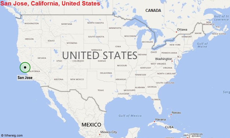
San Jose, California Quick Facts
| Fact | Details |
|---|---|
| City | San Jose |
| County | Santa Clara County |
| State | California |
| State Capital | Sacramento |
| US Region | West |
| Latitude | 37.3382° N |
| Longitude | 121.8863° W |
| Elevation | 82 ft (25 m) |
| Land Area | 176.5 sq mi |
| Water Area | 3.0 sq mi |
| Total Area | 179.5 sq mi |
| Population (2020 Census) | 1,013,240 |
| Population Density | Approximately 5,741 per sq mi |
| ZIP Codes | 95002, 95101, 95103, 95106, 95108, 95109, 95110, 95111, 95112, 95113, 95115, 95116, 95117, 95118, 95119, 95120, 95121, 95122, 95123, 95124, 95125, 95126, 95127, 95128, 95129, 95130, 95131, 95132, 95133, 95134, 95135, 95136, 95138, 95139, 95140, 95141, 95148, 95150, 95151, 95152, 95153, 95154, 95155, 95156, 95157, 95158, 95159, 95160, 95161, 95164, 95170, 95172, 95173, 95190, 95191, 95192, 95193, 95194, 95196 |
| Area Code | 408, 669 |
| Time Zone Standard | Pacific Standard Time (PST, UTC-8) |
| Time Zone Daylight | Pacific Daylight Time (PDT, UTC-7) |
| Currency | US Dollar (USD) |
| FIPS Code | 06-68000 |
| Congressional District | California 16th, 17th, and 18th Congressional Districts |
Location and Surroundings
San Jose is located in Santa Clara County at the southern end of San Francisco Bay in Northern California. It lies between the Santa Cruz Mountains to the west and the Diablo Range to the east, surrounded by many of Silicon Valley's leading technology communities. The city is known as the largest city in Silicon Valley, a global technology hub, and the economic center of Santa Clara County.
Nearby Cities to San Jose, California
- Santa Clara, California - 4 mi Northwest
- Campbell, California - 6 mi West
- Milpitas, California - 8 mi North
- Sunnyvale, California - 10 mi Northwest
- Cupertino, California - 11 mi West
- Mountain View, California - 13 mi Northwest
- Los Gatos, California - 12 mi Southwest
- Palo Alto, California - 18 mi Northwest
- Fremont, California - 18 mi North
- Morgan Hill, California - 23 mi Southeast
San Jose, California Climate and Weather Overview
| Month | Avg High (°F) | Avg Low (°F) | Avg Rainfall (in) |
|---|---|---|---|
| January | 59 | 42 | 3.2 |
| April | 70 | 47 | 1.2 |
| July | 82 | 58 | 0.0 |
| October | 79 | 54 | 0.7 |
| Annual | 73 | 50 | 15.8 |
| Climate Attribute | Details |
|---|---|
| Climate Classification (Köppen) | Warm-Summer Mediterranean (Csb) |
| Annual Rainfall | About 15.8 inches |
| Annual Sunshine Days | Approximately 257 days |
| Hurricane/Tornado Risk | Very low |
| Snowfall | Rare |
Driving Distances from San Jose, California
| City | State | Distance (mi) | Approx. Drive Time |
|---|---|---|---|
| Santa Clara | California | 4 | 10 min |
| Campbell | California | 6 | 15 min |
| Milpitas | California | 8 | 15 min |
| Sunnyvale | California | 10 | 15 min |
| Cupertino | California | 11 | 20 min |
| Los Gatos | California | 12 | 20 min |
| Mountain View | California | 13 | 20 min |
| Palo Alto | California | 18 | 25 min |
| Fremont | California | 18 | 25 min |
| San Francisco | California | 48 | 55 min |
Transportation and Connectivity in San Jose, California
| Category | Details |
|---|---|
| Airport Name | San José Mineta International Airport |
| IATA Code | SJC |
| Port | Port of San Jose (historical inland facilities) |
| Major Highways | I-280, I-680, I-880, US 101, CA 85, CA 87, CA 17, CA 237 |
| Train/Amtrak Service | Amtrak Capitol Corridor, Coast Starlight, Caltrain and ACE |
| Local Bus/Transit Service | Santa Clara Valley Transportation Authority (VTA) |
- U.S. Route 101 - Major north-south corridor connecting Silicon Valley with San Francisco and Los Angeles.
- Interstate 280 - Scenic freeway linking San Jose and San Francisco through the Peninsula.
- Interstate 680 - Connects the city with the East Bay and Contra Costa County.
- Interstate 880 - Important route serving the eastern shore of San Francisco Bay.
- State Route 85 - Major commuter freeway through western Silicon Valley communities.
- State Route 87 - Direct route connecting downtown San Jose and the airport area.
Key Landmarks and Places to Visit in San Jose, California
| Landmark Name | Type |
|---|---|
| Winchester Mystery House | Historic Attraction |
| The Tech Interactive | Science Museum |
| San Jose Museum of Art | Museum |
| Rosicrucian Egyptian Museum | Museum |
| Municipal Rose Garden | Botanical Garden |
| Alum Rock Park | Regional Park |
| SAP Center | Sports and Entertainment Venue |
| History Park | Historic Park |
| Japanese Friendship Garden | Garden |
| Santana Row | Shopping and Entertainment District |
Waterbodies in San Jose, California
Guadalupe River, Coyote Creek, Almaden Reservoir, Calero Reservoir, Anderson Reservoir, Lexington Reservoir, San Francisco Bay, Los Gatos Creek, Stevens Creek Reservoir, Upper Penitencia Creek
Golf Courses in San Jose, California
Cinnabar Hills Golf Club, San Jose Municipal Golf Course, Silver Creek Valley Country Club, The Ranch Golf Club, Los Lagos Golf Course, Boulder Ridge Golf Club, Santa Teresa Golf Club, Pruneridge Golf Club, Deep Cliff Golf Course, Coyote Creek Golf Club
Economy and Major Employers in San Jose, California
| Sector | Major Employer or Industry | Notes |
|---|---|---|
| Technology | Silicon Valley Technology Companies | Foundation of the local economy. |
| Information Technology | Cisco Systems and Related Firms | Major technology employment base. |
| Healthcare | Regional Medical and Healthcare Systems | Large healthcare workforce. |
| Education | San José State University | Major educational institution and employer. |
| Government | City and County Agencies | Significant public-sector employment. |
| Professional Services | Business and Engineering Services | Supports the innovation economy. |
| Manufacturing | Advanced Electronics Manufacturing | Important regional industry. |
| Retail | Commercial and Shopping Centers | Provides substantial employment opportunities. |
Colleges and Schools in San Jose, California
| Institution Name | Type | Level | Notable For |
|---|---|---|---|
| San José State University | Public | University | Oldest public university on the West Coast |
| Santa Clara University | Private | University | Historic Jesuit institution |
| Evergreen Valley College | Public | Community College | Transfer and workforce programs |
| San Jose City College | Public | Community College | Career and academic education |
| East Side Union High School District | Public | K-12 District | Large secondary education district |
| San Jose Unified School District | Public | K-12 District | Serves central city neighborhoods |
San Jose, California - Key Historical Facts
- San Jose was founded in 1777 as El Pueblo de San José de Guadalupe, making it California's first civilian settlement.
- The city briefly served as California's first state capital after statehood in 1850.
- During the nineteenth century, San Jose became an important agricultural center known for orchards and fruit production.
- The rise of the semiconductor industry transformed the city into the heart of Silicon Valley during the twentieth century.
- San Jose experienced rapid population growth as technology companies expanded throughout the region.
- Today, San Jose is the largest city in Northern California and one of the world's leading centers for technology and innovation.
Sources
- Official City of San Jose Website
- Official Santa Clara County Website
- U.S. Census Bureau
- U.S. Geological Survey (USGS)
- National Weather Service
Most Viewed CA Maps
- Where is Los Angeles
- Where is San Diego
- Where is San Francisco
- Where is Anaheim
- Where is Bakersfield
- Where is Chula Vista
- Where is Freemont
- Where is Fresno
- Where is Glendale
- Where is Irvine
- Where is Long Beach
- Where is Modesto
- Where is Oakland
- Where is Paradise
- Where is Riverside
- Where is Sacramento
- Where is San Bernardino
- Where is San Jose
- Where is Santa Ana
- Where is Stockton
- Where is Berkeley
- Where is Clovis
- Where is Corona
- Where is Elk Grove
- Where is Escondido
- Where is Fontana
- Where is Fremont
- Where is Fullerton
- Where is Garden Grove
- Where is Hayward
- Where is Huntington Beach
- Where is Lancaster
- Where is Moreno Valley
- Where is Oceanside
- Where is Ontario
- Where is Orange
- Where is Oxnard
- Where is Palmdale
- Where is Pasadena
- Where is Pomona
- Where is Rancho Cucamonga
- Where is Roseville
- Where is Salinas
- Where is Santa Clara
- Where is Santa Clarita
- Where is Santa Rosa
- Where is Sunnyvale
- Where is Thousand Oaks
- Where is Torrance
- Where is Vallejo
- Where is Victorville
- Where is Visalia