
Where is Vallejo Located? - Vallejo is a city located in the Solano County of California, United States. Vallejo lies between 41.7658 Degrees North latitudes and 72.6734 Degrees West longitudes.
Location Map of Vallejo, California
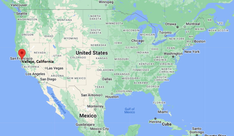
Vallejo Map, California, USA
Where is Vallejo?: The Google Map showing the location of Vallejo in the U.S. state of California.
Where is Vallejo Located?
Vallejo is a city located in the Solano County of California, United States. Vallejo lies between 41.7658 Degrees North latitudes and 72.6734 Degrees West longitudes. According to 2020 U.S.census, the population of Vallejo city is 126090 people and the city has a total area of 30.82 sq mi. The city has numerous parks and recreational facilities.
Most Viewed US Maps
| USA Sttae Map | USA Region Map | USA Road Map |
| USA County Map | Where is USA in World Map? | US ZIP Code Map |
| USA Time Zones Map | US State and Capitals Map | USA Physical Map |
Find 4,400+ U.S. Cities by State - Explore Their Locations and Get Detailed Information
Vallejo, California Quick Facts
| Attribute | Details |
|---|---|
| City | Vallejo |
| County | Solano County |
| State | California |
| State Capital | Sacramento |
| US Region | Western United States |
| Latitude | 38.1041° N |
| Longitude | 122.2566° W |
| Elevation | Approximately 69 ft (21 m) |
| Land Area | 30.7 sq mi |
| Water Area | 24.0 sq mi |
| Total Area | 54.7 sq mi |
| Population (2020 Census) | 126,090 |
| Population Density | Approximately 4,100 per sq mi |
| ZIP Codes | 94589, 94590, 94591, 94592 |
| Area Code | 707 |
| Time Zone Standard | Pacific Standard Time (PST), UTC−8 |
| Time Zone Daylight | Pacific Daylight Time (PDT), UTC−7 |
| Currency | United States Dollar (USD) |
| FIPS Code | 06-81666 |
| Community Type | City |
Transportation and Connectivity in Vallejo, California
| Transportation | Details |
|---|---|
| Airport Name | Buchanan Field Airport |
| IATA Code | CCR |
| Regional Airport | Oakland International Airport and Sacramento International Airport |
| Port | Vallejo Marina and San Francisco Bay Area ports |
| Major Highways | Interstate 80, Interstate 780, State Route 29, State Route 37 |
| Train/Amtrak Service | Amtrak Capitol Corridor service available nearby |
| Ferry Service | San Francisco Bay Ferry service from Vallejo Ferry Terminal |
| Local Transit Service | SolTrans bus service |
- Interstate 80 — Major highway connecting Vallejo with San Francisco, Sacramento, and the East Bay.
- State Route 29 — Provides access through Napa Valley and northern Solano County.
- State Route 37 — Connects Vallejo with Sonoma County and the North Bay region.
- Vallejo Ferry Terminal — Provides passenger ferry connections across San Francisco Bay.
Top Places to Visit in Vallejo, California
| Landmark Name | Type |
|---|---|
| Six Flags Discovery Kingdom | Theme Park and Wildlife Attraction |
| Mare Island Historic Park | Historic District |
| Mare Island Naval Shipyard | Historic Naval Facility |
| Vallejo Naval and Historical Museum | History Museum |
| Blue Rock Springs Park | Community Park |
| Benicia State Recreation Area | State Recreation Area |
| Vallejo Waterfront | Waterfront District |
| Empress Theatre | Historic Theater |
| Vallejo Farmers Market | Local Market |
| Solano County Fairgrounds | Event Venue |
Driving Distances from Vallejo, California to Nearby Cities
| City | State | Distance (mi) | Approx. Drive Time |
|---|---|---|---|
| Benicia | California | 8 mi | 15 minutes |
| Napa | California | 25 mi | 35 minutes |
| Fairfield | California | 20 mi | 25 minutes |
| Oakland | California | 35 mi | 45 minutes |
| San Francisco | California | 35 mi | 50 minutes |
| Sacramento | California | 55 mi | 1 hour |
| Santa Rosa | California | 65 mi | 1 hour 15 minutes |
| Stockton | California | 75 mi | 1 hour 20 minutes |
| San Jose | California | 80 mi | 1 hour 30 minutes |
| Los Angeles | California | 390 mi | 6 hours |
Colleges and Universities Near Vallejo, California
| Institution Name | Type | Level | Notable For |
|---|---|---|---|
| Touro University California | Private | University | Health sciences, medicine, pharmacy, and graduate programs |
| Solano Community College | Public | Community College | Transfer programs, career training, and workforce education |
| California State University, Maritime Academy | Public | University | Maritime studies, engineering, business, and marine transportation |
| University of California, Davis | Public | University | Agriculture, veterinary medicine, research, and sciences |
| Vallejo City Unified School District | Public | K–12 District | Local public education |
Waterbodies Near Vallejo, California
San Pablo Bay, Carquinez Strait, Napa River, Mare Island Strait, Suisun Bay, and nearby San Francisco Bay Area waterways
Golf Courses and Stadiums Near Vallejo
Golf Courses: Hiddenbrooke Golf Club, Blue Rock Springs Golf Course, and nearby Solano County golf facilities. Stadiums: Wilson Park, Vallejo High School athletic facilities, and nearby Bay Area sports venues.
Key Landmarks and Places to Visit in Vallejo, California
| Landmark Name | Type |
|---|---|
| Mare Island Historic Park | Historic District |
| Mare Island Naval Shipyard | Historic Naval Facility |
| Six Flags Discovery Kingdom | Theme Park and Wildlife Attraction |
| Vallejo Naval and Historical Museum | History Museum |
| Empress Theatre | Historic Theater |
| Vallejo Waterfront | Waterfront District |
| Blue Rock Springs Park | Public Park |
| Benicia State Recreation Area | State Recreation Area |
| Carquinez Strait Scenic Area | Natural Landmark |
| Solano County Fairgrounds | Event Venue |
Vallejo, California — Key Historical Facts
- The Vallejo area was originally inhabited by the Coast Miwok and Suisun Indigenous peoples before European settlement.
- Vallejo was founded in 1851 and named after General Mariano Guadalupe Vallejo, an important figure in early California history.
- The city served briefly as the capital of California in 1852 and again in 1853 before the state capital moved to Sacramento.
- Mare Island Naval Shipyard opened in 1854 and became the first United States Navy shipyard on the West Coast.
- The city's economy developed around shipbuilding, naval activities, transportation, and waterfront industries.
- Today, Vallejo is known for its historic naval heritage, waterfront location, ferry connections, cultural attractions, and access to the San Francisco Bay Area.
References
- United States Census Bureau
- City of Vallejo Official Website
- Solano County Official Website
- State of California Official Website
- Visit Vallejo Tourism
California Related Links
- Where is Los Angeles
- Where is San Diego
- Where is San Francisco
- Where is Anaheim
- Where is Bakersfield
- Where is Chula Vista
- Where is Freemont
- Where is Fresno
- Where is Glendale
- Where is Irvine
- Where is Long Beach
- Where is Modesto
- Where is Oakland
- Where is Paradise
- Where is Riverside
- Where is Sacramento
- Where is San Bernardino
- Where is San Jose
- Where is Santa Ana
- Where is Stockton
- Where is Berkeley
- Where is Clovis
- Where is Corona
- Where is Elk Grove
- Where is Escondido
- Where is Fontana
- Where is Fremont
- Where is Fullerton
- Where is Garden Grove
- Where is Hayward
- Where is Huntington Beach
- Where is Lancaster
- Where is Moreno Valley
- Where is Oceanside
- Where is Ontario
- Where is Orange
- Where is Oxnard
- Where is Palmdale
- Where is Pasadena
- Where is Pomona
- Where is Rancho Cucamonga
- Where is Roseville
- Where is Salinas
- Where is Santa Clara
- Where is Santa Clarita
- Where is Santa Rosa
- Where is Sunnyvale
- Where is Thousand Oaks
- Where is Torrance
- Where is Vallejo
- Where is Victorville
- Where is Visalia