Written and fact-checked by Whereig.com Web Team | Last Updated: December 16, 2025, 14:30 ET
Map of Solano County - Solano County is a county located in the U.S. state of California. Solano County Map showing cities, highways, important places and water bodies. Get Where is Solano County located in the map, major cities in Solano county, population, areas, and places of interest.
Solano County Map, California
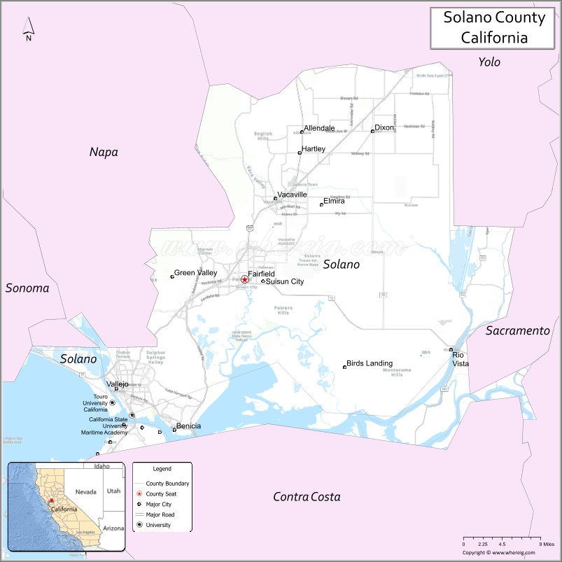
About Solano County Map, California: The map showing the county boundary, county seat, major cities, highways, water bodies and neighbouring counties.
Most Viewed Links
About Solano County, California
Solano County is a county located in the northeastern part of the San Francisco Bay Area in California. Its county seat is Fairfield, and as of the 2020 census, the population was estimated to be around 450,000 people.According to the United States Census Bureau, the county has a total area of 828 sq mi (2,145 km2). Solano County was established on 1850.
Solano County is known for its diverse communities and rich history. The county is home to several notable cities, including Vallejo, Fairfield, and Vacaville. It is also home to several military installations, including Travis Air Force Base and the California Maritime Academy.
The economy of Solano County is diverse, with a variety of industries contributing to its growth. The county is home to several large employers, including the Anheuser-Busch brewery in Fairfield and the Jelly Belly candy factory in Fairfield. The county is also home to several wineries and vineyards, which produce award-winning wines.
Solano County has a rich history, with evidence of human habitation dating back thousands of years. The county was home to several Native American tribes, including the Patwin and Suisun. In the 19th century, the area was settled by European-Americans during the California Gold Rush. Today, the county has several historic sites, including the Suisun City Historic Waterfront District, the Travis Air Force Base Museum, and the Western Railway Museum.
Facts about Solano County, California
| Country | United States |
| State | California |
| Region | San Francisco Bay Area (North Bay) |
| County Seat | Fairfield |
| Named After | Chief Solano |
| Established | 1850 |
| Organized | 1850 |
| Coordinates | 38.2675° N, 121.9390° W |
| Total Area | 906 sq mi |
| Land Area | 822 sq mi |
| Water Area | 84 sq mi |
| Population (2020) | 453,491 |
| Population Rank | Mid-sized county in California |
| Major Cities | Vallejo, Fairfield, Vacaville, Benicia |
| Main Industries | Manufacturing, Logistics, Government Services, Healthcare |
| Major Airport | None (nearest major airports outside the county) |
| Time Zone | Pacific Time (UTC−08:00) |
| Known For | Travis Air Force Base, San Pablo Bay, Delta waterways, Military presence |
| Website | https://www.solanocounty.com |
Ctities and Towns in Solano County
| City Name | Type | Population (2020) | Pop. Density | Area | Incorporated |
|---|---|---|---|---|---|
| Benicia | City | 27,131 | 2,118.0/sq mi (817.7/km2) | 12.81 sq mi (33.2 km2) | March 27, 1850 |
| Dixon | City | 18,988 | 2,674.4/sq mi (1,032.6/km2) | 7.1 sq mi (18.4 km2) | March 30, 1878 |
| Fairfield | City | 119,881 | 2,882.4/sq mi (1,112.9/km2) | 41.59 sq mi (107.7 km2) | December 12, 1903 |
| Rio Vista | City | 10,005 | 1,515.9/sq mi (585.3/km2) | 6.6 sq mi (17.1 km2) | January 6, 1894 |
| Suisun City | City | 29,518 | 7,361.1/sq mi (2,842.1/km2) | 4.01 sq mi (10.4 km2) | October 9, 1868 |
| Vacaville | City | 102,386 | 3,427.7/sq mi (1,323.5/km2) | 29.87 sq mi (77.4 km2) | August 9, 1892 |
| Vallejo | City | 126,090 | 4,145.0/sq mi (1,600.4/km2) | 30.42 sq mi (78.8 km2) | March 30, 1868 |
Places to Visit in Solano County
Top places to visit in Solano includes Six Flags Discovery, Golden Gate Bridge, Alcatraz Island, Paradise Valley Golf Course, Muir Woods National, Rush Ranch Open Space, UC Davis Arboretum.
Highways in Solano County
Interstate 80, Interstate 505, Interstate 680, Interstate 780, State Route 12, State Route 29, State Route 37, State Route 84, State Route 113.
Nearest Airports
Nearest airport of Solano is Sacramento International Airport (SMF / KSMF).
- Alameda County Map
- Alpine County Map
- Amador County Map
- Butte County Map
- Calaveras County Map
- Colusa County Map
- Contra Costa County Map
- Del Norte County Map
- El Dorado County Map
- Fresno County Map
- Glenn County Map
- Humboldt County Map
- Imperial County Map
- Inyo County Map
- Kern County Map
- Kings County Map
- Lake County Map
- Lassen County Map
- Los Angeles County Map
- Madera County Map
- Marin County Map
- Mariposa County Map
- Mendocino County Map
- Merced County Map
- Modoc County Map
- Mono County Map
- Monterey County Map
- Napa County Map
- Nevada County Map
- Orange County Map
- Placer County Map
- Plumas County Map
- Riverside County Map
- Sacramento County Map
- San Benito County Map
- San Bernardino County Map
- San Diego County Map
- San Francisco County Map
- San Joaquin County Map
- San Luis Obispo County Map
- San Mateo County Map
- Santa Barbara County Map
- Santa Clara County Map
- Santa Cruz County Map
- Shasta County Map
- Sierra County Map
- Siskiyou County Map
- Solano County Map
- Sonoma County Map
- Stanislaus County Map
- Sutter County Map
- Tehama County Map
- Trinity County Map
- Tulare County Map
- Tuolumne County Map
- Ventura County Map
- Yolo County Map
- Yuba County Map
- Alabama Counties
- Alaska boroughs
- Arizona Counties
- Arkansas Counties
- California County Map
- Colorado Counties
- Connecticut Counties
- Delaware Counties
- Florida County Map
- Georgia County Map
- Hawaii Counties
- Idaho Counties
- Illinois Counties
- Indiana Counties
- Iowa Counties
- Kansas Counties
- Kentucky Counties
- Louisiana Counties
- Maine Counties
- Maryland Counties
- Massachusetts Counties
- Michigan County Map
- Minnesota Counties
- Mississippi Counties
- Missouri Counties
- Montana Counties
- Nebraska Counties
- Nevada Counties
- New York Counties
- New Hampshire Counties
- New Jersey Counties
- New Mexico Counties
- North Carolina Counties
- North Dakota Counties
- Ohio County Map
- Oklahoma Counties
- Oregon Counties
- Pennsylvania Counties
- Rhode Island Counties
- South Carolina Counties
- South Dakota Counties
- Map of Tennessee
- Texas County Map
- Utah Counties
- Vermont Counties
- Virginia Counties
- Washington Counties
- West Virginia Counties
- Wisconsin Counties
- Wyoming Counties