Written and fact-checked by Whereig.com Web Team | Last Updated: December 16, 2025, 14:30 ET
Map of Sutter County - Sutter County is a county located in the U.S. state of California. Sutter County Map showing cities, highways, important places and water bodies. Get Where is Sutter County located in the map, major cities in Sutter county, population, areas, and places of interest.
Sutter County Map, California
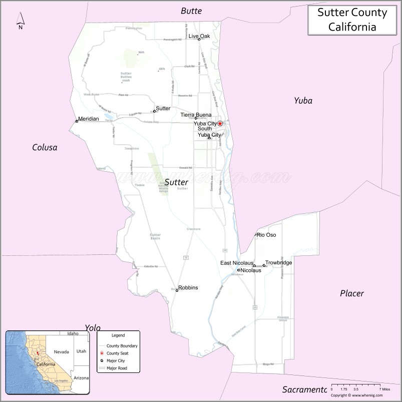
About Sutter County Map, California: The map showing the county boundary, county seat, major cities, highways, water bodies and neighbouring counties.
Most Viewed Links
About Sutter County, California
Sutter County is a county located in the Central Valley region of California, United States. The county seat is Yuba City. According to the United States Census Bureau, the county has a total area of 608 square miles (1,573 km²), of which 602 square miles (1,559 km²) is land and 6.1 square miles (16 km²) (1.0%) is water. the population of Sutter County is 99063 people and population density.Sutter County was established on 1850.
As of the 2020 United States Census, the population of Sutter County was 98,954. The county is known for its agriculture, with crops such as rice, almonds, walnuts, and peaches being among the top products grown in the area.
Major cities and towns in Sutter County include Yuba City, Live Oak, and Sutter. The county is bordered by Butte County to the north, Yuba County to the east, and Sacramento County to the south.
Facts about Sutter County, California
| Country | United States |
| State | California |
| Region | Northern California (Sacramento Valley) |
| County Seat | Yuba City |
| Named After | John Sutter |
| Established | 1850 |
| Organized | 1850 |
| Coordinates | 39.0345° N, 121.6946° W |
| Total Area | 608 sq mi |
| Land Area | 602 sq mi |
| Water Area | 6 sq mi |
| Population (2020) | 99,633 |
| Population Rank | Small-to-mid-sized county in California |
| Major Cities | Yuba City, Live Oak |
| Main Industries | Agriculture, Food Processing, Government Services |
| Major Airport | None (nearest commercial airports outside the county) |
| Time Zone | Pacific Time (UTC−08:00) |
| Known For | Rice farming, Feather River, Agricultural production |
| Website | https://www.suttercounty.org |
Ctities and Towns in Sutter County
| City Name | Type | Population (2020) | Pop. Density | Area | Incorporated |
|---|---|---|---|---|---|
| Live Oak | City | 9,106 | 2,918.6/sq mi (1,126.9/km2) | 3.12 sq mi (8.1 km2) | January 22, 1947 |
| Yuba City | City | 70,117 | 4,680.7/sq mi (1,807.2/km2) | 14.98 sq mi (38.8 km2) | January 23, 1908 |
Places to Visit in Sutter County
Top places to visit in Sutter includes Sutter County Museum, Bella Grace Vineyards, Sutter Buttes, Sutter National Wildlife Refuge.
Highways in Sutter County
State Route 20, State Route 70, State Route 99, State Route 113.
Nearest Airports
Nearest airport of Sutter is Sutter County Airport.
- Alameda County Map
- Alpine County Map
- Amador County Map
- Butte County Map
- Calaveras County Map
- Colusa County Map
- Contra Costa County Map
- Del Norte County Map
- El Dorado County Map
- Fresno County Map
- Glenn County Map
- Humboldt County Map
- Imperial County Map
- Inyo County Map
- Kern County Map
- Kings County Map
- Lake County Map
- Lassen County Map
- Los Angeles County Map
- Madera County Map
- Marin County Map
- Mariposa County Map
- Mendocino County Map
- Merced County Map
- Modoc County Map
- Mono County Map
- Monterey County Map
- Napa County Map
- Nevada County Map
- Orange County Map
- Placer County Map
- Plumas County Map
- Riverside County Map
- Sacramento County Map
- San Benito County Map
- San Bernardino County Map
- San Diego County Map
- San Francisco County Map
- San Joaquin County Map
- San Luis Obispo County Map
- San Mateo County Map
- Santa Barbara County Map
- Santa Clara County Map
- Santa Cruz County Map
- Shasta County Map
- Sierra County Map
- Siskiyou County Map
- Solano County Map
- Sonoma County Map
- Stanislaus County Map
- Sutter County Map
- Tehama County Map
- Trinity County Map
- Tulare County Map
- Tuolumne County Map
- Ventura County Map
- Yolo County Map
- Yuba County Map
- Alabama Counties
- Alaska boroughs
- Arizona Counties
- Arkansas Counties
- California County Map
- Colorado Counties
- Connecticut Counties
- Delaware Counties
- Florida County Map
- Georgia County Map
- Hawaii Counties
- Idaho Counties
- Illinois Counties
- Indiana Counties
- Iowa Counties
- Kansas Counties
- Kentucky Counties
- Louisiana Counties
- Maine Counties
- Maryland Counties
- Massachusetts Counties
- Michigan County Map
- Minnesota Counties
- Mississippi Counties
- Missouri Counties
- Montana Counties
- Nebraska Counties
- Nevada Counties
- New York Counties
- New Hampshire Counties
- New Jersey Counties
- New Mexico Counties
- North Carolina Counties
- North Dakota Counties
- Ohio County Map
- Oklahoma Counties
- Oregon Counties
- Pennsylvania Counties
- Rhode Island Counties
- South Carolina Counties
- South Dakota Counties
- Map of Tennessee
- Texas County Map
- Utah Counties
- Vermont Counties
- Virginia Counties
- Washington Counties
- West Virginia Counties
- Wisconsin Counties
- Wyoming Counties