Written and fact-checked by Whereig.com Web Team | Last Updated: December 16, 2025, 14:30 ET
Map of Stanislaus County - Stanislaus County is a county located in the U.S. state of California. Stanislaus County Map showing cities, highways, important places and water bodies. Get Where is Stanislaus County located in the map, major cities in Stanislaus county, population, areas, and places of interest.
Stanislaus County Map, California
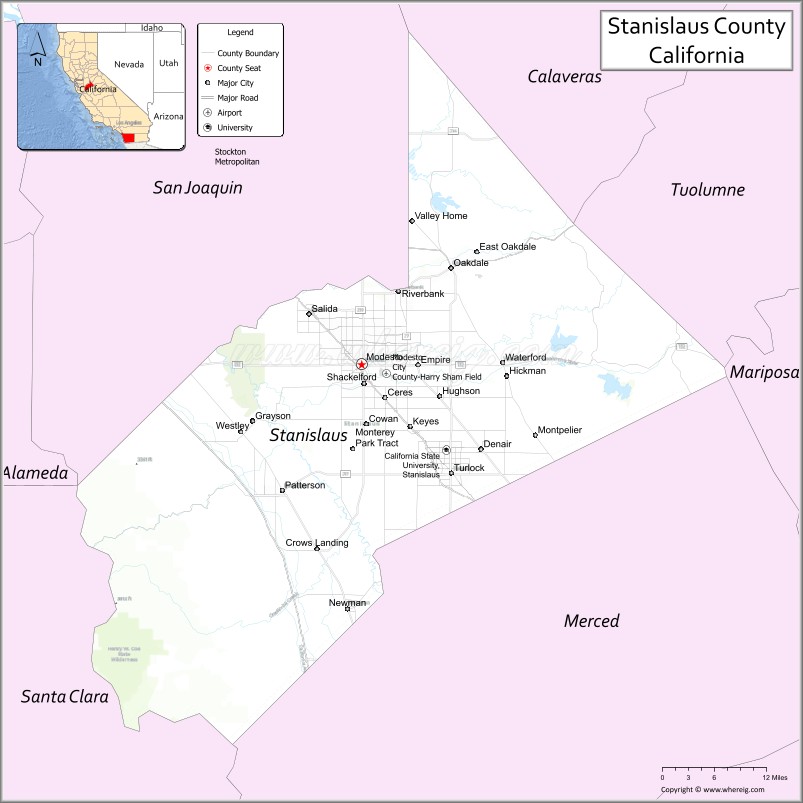
About Stanislaus County Map, California: The map showing the county boundary, county seat, major cities, highways, water bodies and neighbouring counties.
Most Viewed Links
About Stanislaus County, California
Stanislaus County is a county located in the central valley of California. It's county seat is Modesto. As per 2020 census, the population of Stanislaus County is 552999 people and population density is square miles. According to the United States Census Bureau, the county has a total area of 1,495 sq mi (3,872 km2). Stanislaus County was established on 1854.
Stanislaus County is known for its rich agricultural history and diverse communities. The county is home to several notable cities, including Modesto, Turlock, and Ceres. It is also home to several colleges and universities, including California State University, Stanislaus.
The economy of Stanislaus County is primarily based on agriculture, with almonds, milk, and poultry being the most important crops. The county is also home to several large employers, including the Memorial Medical Center and the Stanislaus County Government.
Stanislaus County has a rich history, with evidence of human habitation dating back thousands of years. The county was home to several Native American tribes, including the Yokuts and the Miwok. In the 19th century, the area was settled by European-Americans during the California Gold Rush. Today, the county has several historic sites, including the McHenry Mansion in Modesto and the Turlock Historical Society Museum.
Facts about Stanislaus County, California
| Country | United States |
| State | California |
| Region | Central California (San Joaquin Valley) |
| County Seat | Modesto |
| Named After | Stanislaus River |
| Established | 1854 |
| Organized | 1854 |
| Coordinates | 37.5591° N, 120.9979° W |
| Total Area | 1,515 sq mi |
| Land Area | 1,495 sq mi |
| Water Area | 20 sq mi |
| Population (2020) | 552,878 |
| Population Rank | Mid-sized county in California |
| Major Cities | Modesto, Turlock, Ceres, Oakdale |
| Main Industries | Agriculture, Food Processing, Healthcare, Manufacturing |
| Major Airport | Modesto City–County Airport |
| Time Zone | Pacific Time (UTC−08:00) |
| Known For | Agricultural production, Central Valley farming, Birthplace of George Lucas |
| Website | https://www.stancounty.com |
Ctities and Towns in Stanislaus County
| City Name | Type | Population (2020) | Pop. Density | Area | Incorporated |
|---|---|---|---|---|---|
| Ceres | City | 49,302 | 5,189.7/sq mi (2,003.7/km2) | 9.5 sq mi (24.6 km2) | February 25, 1918 |
| Hughson | City | 7,481 | 3,916.8/sq mi (1,512.3/km2) | 1.91 sq mi (4.9 km2) | December 9, 1972 |
| Modesto | City | 218,464 | 5,074.7/sq mi (1,959.3/km2) | 43.05 sq mi (111.5 km2) | August 6, 1884 |
| Newman | City | 12,351 | 5,995.6/sq mi (2,314.9/km2) | 2.06 sq mi (5.3 km2) | June 10, 1908 |
| Oakdale | City | 23,181 | 3,720.9/sq mi (1,436.6/km2) | 6.23 sq mi (16.1 km2) | November 24, 1906 |
| Patterson | City | 23,781 | 3,052.8/sq mi (1,178.7/km2) | 7.79 sq mi (20.2 km2) | December 22, 1919 |
| Riverbank | City | 24,865 | 5,279.2/sq mi (2,038.3/km2) | 4.71 sq mi (12.2 km2) | August 23, 1922 |
| Turlock | City | 72,740 | 4,301.6/sq mi (1,660.9/km2) | 16.91 sq mi (43.8 km2) | February 15, 1908 |
| Waterford | City | 9,120 | 3,864.4/sq mi (1,492.1/km2) | 2.36 sq mi (6.1 km2) | November 7, 1969 |
Places to Visit in Stanislaus County
Top places to visit in Stanislaus includes Yosemite National Park, Graceada Park, San Joaquin River National Wildlife, Knights Ferry Covered Bridge, .
Highways in Stanislaus County
Interstate 5, State Route 4, State Route 33, State Route 99, State Route 108, State Route 120, State Route 132, State Route 165, State Route 219.
Nearest Airports
Nearest airport of Stanislaus are Francisco International Airport (SFO), Los Angeles International Airport (LAX), Sacramento International Airport (SMF), Fresno Yosemite International Airport (FAT).
- Alameda County Map
- Alpine County Map
- Amador County Map
- Butte County Map
- Calaveras County Map
- Colusa County Map
- Contra Costa County Map
- Del Norte County Map
- El Dorado County Map
- Fresno County Map
- Glenn County Map
- Humboldt County Map
- Imperial County Map
- Inyo County Map
- Kern County Map
- Kings County Map
- Lake County Map
- Lassen County Map
- Los Angeles County Map
- Madera County Map
- Marin County Map
- Mariposa County Map
- Mendocino County Map
- Merced County Map
- Modoc County Map
- Mono County Map
- Monterey County Map
- Napa County Map
- Nevada County Map
- Orange County Map
- Placer County Map
- Plumas County Map
- Riverside County Map
- Sacramento County Map
- San Benito County Map
- San Bernardino County Map
- San Diego County Map
- San Francisco County Map
- San Joaquin County Map
- San Luis Obispo County Map
- San Mateo County Map
- Santa Barbara County Map
- Santa Clara County Map
- Santa Cruz County Map
- Shasta County Map
- Sierra County Map
- Siskiyou County Map
- Solano County Map
- Sonoma County Map
- Stanislaus County Map
- Sutter County Map
- Tehama County Map
- Trinity County Map
- Tulare County Map
- Tuolumne County Map
- Ventura County Map
- Yolo County Map
- Yuba County Map
- Alabama Counties
- Alaska boroughs
- Arizona Counties
- Arkansas Counties
- California County Map
- Colorado Counties
- Connecticut Counties
- Delaware Counties
- Florida County Map
- Georgia County Map
- Hawaii Counties
- Idaho Counties
- Illinois Counties
- Indiana Counties
- Iowa Counties
- Kansas Counties
- Kentucky Counties
- Louisiana Counties
- Maine Counties
- Maryland Counties
- Massachusetts Counties
- Michigan County Map
- Minnesota Counties
- Mississippi Counties
- Missouri Counties
- Montana Counties
- Nebraska Counties
- Nevada Counties
- New York Counties
- New Hampshire Counties
- New Jersey Counties
- New Mexico Counties
- North Carolina Counties
- North Dakota Counties
- Ohio County Map
- Oklahoma Counties
- Oregon Counties
- Pennsylvania Counties
- Rhode Island Counties
- South Carolina Counties
- South Dakota Counties
- Map of Tennessee
- Texas County Map
- Utah Counties
- Vermont Counties
- Virginia Counties
- Washington Counties
- West Virginia Counties
- Wisconsin Counties
- Wyoming Counties