Written and fact-checked by Whereig.com Web Team | Last Updated: December 16, 2025, 14:30 ET
Map of Siskiyou County - Siskiyou County is a county located in the U.S. state of California. Siskiyou County Map showing cities, highways, important places and water bodies. Get Where is Siskiyou County located in the map, major cities in Siskiyou county, population, areas, and places of interest.
Siskiyou County Map, California
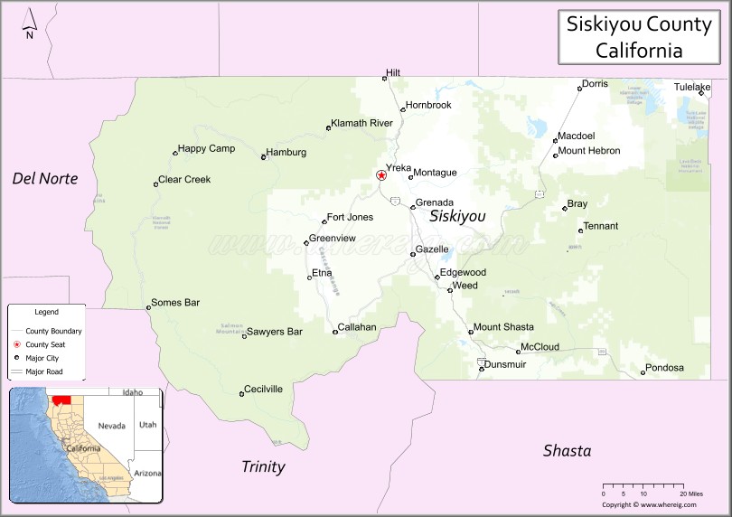
About Siskiyou County Map, California: The map showing the county boundary, county seat, major cities, highways, water bodies and neighbouring counties.
Most Viewed Links
About Siskiyou County, California
Siskiyou County is a county located in the northernmost part of California, bordering the state of Oregon. It's county seat is Yreka. As per 2020 census, the population of Siskiyou County is 44118 people and population density is square miles. According to the United States Census Bureau, the county has a total area of 6,287 sq mi (16,283 km2). Siskiyou County was established on 1852.
Siskiyou County is known for its scenic beauty, with a variety of landscapes ranging from mountains and forests to rivers and lakes. The county is home to several notable natural attractions, including Mount Shasta, the Klamath River, and the Marble Mountains Wilderness Area.
The economy of Siskiyou County is primarily based on natural resources, including timber, mining, and agriculture. The county is also home to several outdoor recreational activities, including hunting, fishing, hiking, and skiing. Tourism is an important industry in the county, with visitors coming to enjoy the natural beauty and outdoor activities.
Siskiyou County has a rich history, with evidence of human habitation dating back thousands of years. The county was home to several Native American tribes, including the Karuk, Shasta, and Modoc. In the 19th century, the area was settled by European-Americans during the California Gold Rush. Today, the county has several historic sites, including the Siskiyou County Courthouse, the Yreka Historic District, and the Lava Beds National Monument.
Siskiyou County is a county located in the U.S. state of California. It's county seat is Yreka. As per 2020 census, the population of Siskiyou County is 44118 people and population density is square miles. According to the United States Census Bureau, the county has a total area of 6,287 sq mi (16,283 km2). Siskiyou County was established on 1852.
Facts about Siskiyou County, California
| Country | United States |
| State | California |
| Region | Northern California (Shasta Cascade & Klamath Mountains) |
| County Seat | Yreka |
| Named After | Siskiyou Mountains |
| Established | 1852 |
| Organized | 1852 |
| Coordinates | 41.5926° N, 122.5406° W |
| Total Area | 6,347 sq mi |
| Land Area | 6,278 sq mi |
| Water Area | 69 sq mi |
| Population (2020) | 44,076 |
| Population Rank | One of the least populous counties in California |
| Major Cities | Yreka, Mount Shasta, Weed |
| Main Industries | Agriculture, Forestry, Government Services, Tourism |
| Major Airport | None (nearest commercial airports outside the county) |
| Time Zone | Pacific Time (UTC−08:00) |
| Known For | Mount Shasta, Klamath National Forest, Scenic mountain landscapes, Outdoor recreation |
| Website | https://www.co.siskiyou.ca.us |
Ctities and Towns in Siskiyou County
| City Name | Type | Population (2020) | Pop. Density | Area | Incorporated |
|---|---|---|---|---|---|
| Dorris | City | 860 | 1,228.6/sq mi (474.4/km2) | 0.7 sq mi (1.8 km2) | December 23, 1908 |
| Dunsmuir | City | 1,707 | 1,066.9/sq mi (411.9/km2) | 1.6 sq mi (4.1 km2) | August 7, 1909 |
| Etna | City | 678 | 892.1/sq mi (344.4/km2) | 0.76 sq mi (2 km2) | March 13, 1878 |
| Fort Jones | City | 695 | 1,158.3/sq mi (447.2/km2) | 0.6 sq mi (1.6 km2) | March 16, 1872 |
| Montague | City | 1,226 | 688.8/sq mi (265.9/km2) | 1.78 sq mi (4.6 km2) | January 28, 1909 |
| Mount Shasta | City | 3,223 | 854.9/sq mi (330.1/km2) | 3.77 sq mi (9.8 km2) | May 31, 1905 |
| Tulelake | City | 902 | 2,200.0/sq mi (849.4/km2) | 0.41 sq mi (1.1 km2) | March 1, 1937 |
| Weed | City | 2,862 | 593.8/sq mi (229.3/km2) | 4.82 sq mi (12.5 km2) | January 25, 1961 |
| Yreka | City | 7,807 | 781.5/sq mi (301.7/km2) | 9.99 sq mi (25.9 km2) | April 21, 1857 |
Places to Visit in Siskiyou County
Top places to visit in Siskiyou includes Lava Beds National, Hedge Creek Falls, Railroad Park Resort , Mount Shasta, Pluto's Cave, Living Memorial Sculpture, Headwaters of the Sacramento, Mt. Shasta Ski Park, McCloud River Falls Trailhead, .
Highways in Siskiyou County
Interstate 5, U.S. Route 97, State Route 3, State Route 89, State Route 96, State Route 139, State Route 161, State Route 263, State Route 265.
Nearest Airports
Nearest airport of Siskiyou is Rogue Valley International-Medford Airport (MFR / KMFR).
- Alameda County Map
- Alpine County Map
- Amador County Map
- Butte County Map
- Calaveras County Map
- Colusa County Map
- Contra Costa County Map
- Del Norte County Map
- El Dorado County Map
- Fresno County Map
- Glenn County Map
- Humboldt County Map
- Imperial County Map
- Inyo County Map
- Kern County Map
- Kings County Map
- Lake County Map
- Lassen County Map
- Los Angeles County Map
- Madera County Map
- Marin County Map
- Mariposa County Map
- Mendocino County Map
- Merced County Map
- Modoc County Map
- Mono County Map
- Monterey County Map
- Napa County Map
- Nevada County Map
- Orange County Map
- Placer County Map
- Plumas County Map
- Riverside County Map
- Sacramento County Map
- San Benito County Map
- San Bernardino County Map
- San Diego County Map
- San Francisco County Map
- San Joaquin County Map
- San Luis Obispo County Map
- San Mateo County Map
- Santa Barbara County Map
- Santa Clara County Map
- Santa Cruz County Map
- Shasta County Map
- Sierra County Map
- Siskiyou County Map
- Solano County Map
- Sonoma County Map
- Stanislaus County Map
- Sutter County Map
- Tehama County Map
- Trinity County Map
- Tulare County Map
- Tuolumne County Map
- Ventura County Map
- Yolo County Map
- Yuba County Map
- Alabama Counties
- Alaska boroughs
- Arizona Counties
- Arkansas Counties
- California County Map
- Colorado Counties
- Connecticut Counties
- Delaware Counties
- Florida County Map
- Georgia County Map
- Hawaii Counties
- Idaho Counties
- Illinois Counties
- Indiana Counties
- Iowa Counties
- Kansas Counties
- Kentucky Counties
- Louisiana Counties
- Maine Counties
- Maryland Counties
- Massachusetts Counties
- Michigan County Map
- Minnesota Counties
- Mississippi Counties
- Missouri Counties
- Montana Counties
- Nebraska Counties
- Nevada Counties
- New York Counties
- New Hampshire Counties
- New Jersey Counties
- New Mexico Counties
- North Carolina Counties
- North Dakota Counties
- Ohio County Map
- Oklahoma Counties
- Oregon Counties
- Pennsylvania Counties
- Rhode Island Counties
- South Carolina Counties
- South Dakota Counties
- Map of Tennessee
- Texas County Map
- Utah Counties
- Vermont Counties
- Virginia Counties
- Washington Counties
- West Virginia Counties
- Wisconsin Counties
- Wyoming Counties