Written and fact-checked by Whereig.com Web Team | Last Updated: December 16, 2025, 14:30 ET
Map of San Joaquin County - San Joaquin County is a county located in the U.S. state of California. San Joaquin County Map showing cities, highways, important places and water bodies. Get Where is San Joaquin County located in the map, major cities in San Joaquin county, population, areas, and places of interest.
San Joaquin County Map, California
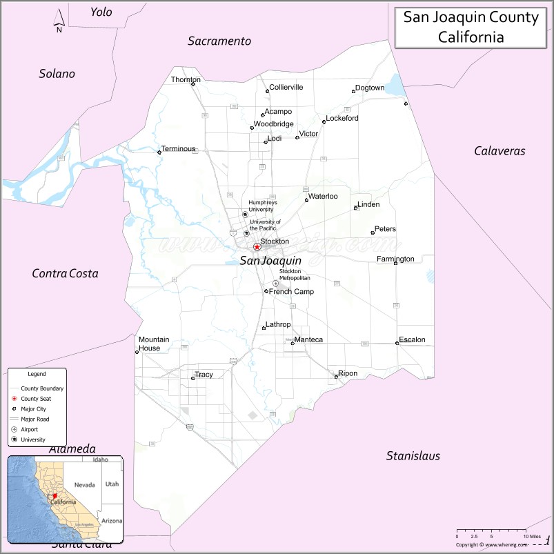
About San Joaquin County Map, California: The map showing the county boundary, county seat, major cities, highways, water bodies and neighbouring counties.
Most Viewed Links
About San Joaquin County, California
San Joaquin County is a county located in central California, with its county seat in the city of Stockton. The county has an estimated population of over 770,000 people as of 2021.According to the United States Census Bureau, the county has a total area of 1,399 sq mi (3,623 km2). San Joaquin County was established on 1850.
San Joaquin County is known for its agricultural industry, with crops such as cherries, tomatoes, and almonds being major contributors to the local economy. The county is also home to several historic landmarks, including the Haggin Museum, which showcases local history and art.
The county is also a popular destination for outdoor recreation, with the Delta waterways and parks providing opportunities for boating, fishing, and hiking. Additionally, the county is home to several universities and colleges, including the University of the Pacific and San Joaquin Delta College.
Economically, San Joaquin County is driven by agriculture, healthcare, education, and logistics. The Port of Stockton is a major transportation hub for the county, handling a wide range of goods and commodities. The county's diverse economy and central location within California have contributed to its growth and development.
Facts about San Joaquin County, California
| Country | United States |
| State | California |
| Region | Central California (San Joaquin Valley) |
| County Seat | Stockton |
| Named After | San Joaquin River (named for Saint Joachim) |
| Established | 1850 |
| Organized | 1850 |
| Coordinates | 37.9350° N, 121.2720° W |
| Total Area | 1,426 sq mi |
| Land Area | 1,392 sq mi |
| Water Area | 34 sq mi |
| Population (2020) | 779,233 |
| Population Rank | One of the largest counties in California |
| Major Cities | Stockton, Tracy, Manteca, Lodi |
| Main Industries | Agriculture, Logistics, Manufacturing, Healthcare, Government Services |
| Major Airport | Stockton Metropolitan Airport |
| Time Zone | Pacific Time (UTC−08:00) |
| Known For | Agricultural production, Inland port of Stockton, Delta waterways |
| Website | https://www.sjgov.org |
Ctities and Towns in San Joaquin County
| City Name | Type | Population (2020) | Pop. Density | Area | Incorporated |
|---|---|---|---|---|---|
| Escalon | City | 7,472 | 3,277.2/sq mi (1,265.3/km2) | 2.28 sq mi (5.9 km2) | March 12, 1957 |
| Lathrop | City | 28,701 | 1,447.4/sq mi (558.8/km2) | 19.83 sq mi (51.4 km2) | July 1, 1989 |
| Lodi | City | 66,348 | 4,864.2/sq mi (1,878.1/km2) | 13.64 sq mi (35.3 km2) | December 6, 1906 |
| Manteca | City | 83,498 | 3,903.6/sq mi (1,507.2/km2) | 21.39 sq mi (55.4 km2) | June 5, 1918 |
| Ripon | City | 16,013 | 3,004.3/sq mi (1,160.0/km2) | 5.33 sq mi (13.8 km2) | November 27, 1945 |
| Stockton | City | 320,804 | 5,156.8/sq mi (1,991.0/km2) | 62.21 sq mi (161.1 km2) | July 23, 1850 |
| Tracy | City | 93,000 | 3,592.1/sq mi (1,386.9/km2) | 25.89 sq mi (67.1 km2) | July 22, 1910 |
Places to Visit in San Joaquin County
Top places to visit in San Joaquin includes Lodi Lake, Stockton Arena, Micke Grove Regional Park, Michael David Winery, Oak Grove Regional Park, Micke Grove Zoo, Oak Farm Vineyards, Skydive California, Pixie Woods & Yum Yum House, Lodi Lake Beach, Central Community Park, Nelson Park, McHenry Recreation Area, Louis Park, Angel Cruz Park, Lucca Winery, Stillman Magee Park, Ski Beach, University Park World Peace.
Highways in San Joaquin County
Interstate 5, Interstate 205, Interstate 580, State Route 4, State Route 12, State Route 26, State Route 33, State Route 88, State Route 99, State Route 120, State Route 132.
Nearest Airports
Nearest airport of San Joaquin is San Joaquin Airport-CA32.
- Alameda County Map
- Alpine County Map
- Amador County Map
- Butte County Map
- Calaveras County Map
- Colusa County Map
- Contra Costa County Map
- Del Norte County Map
- El Dorado County Map
- Fresno County Map
- Glenn County Map
- Humboldt County Map
- Imperial County Map
- Inyo County Map
- Kern County Map
- Kings County Map
- Lake County Map
- Lassen County Map
- Los Angeles County Map
- Madera County Map
- Marin County Map
- Mariposa County Map
- Mendocino County Map
- Merced County Map
- Modoc County Map
- Mono County Map
- Monterey County Map
- Napa County Map
- Nevada County Map
- Orange County Map
- Placer County Map
- Plumas County Map
- Riverside County Map
- Sacramento County Map
- San Benito County Map
- San Bernardino County Map
- San Diego County Map
- San Francisco County Map
- San Joaquin County Map
- San Luis Obispo County Map
- San Mateo County Map
- Santa Barbara County Map
- Santa Clara County Map
- Santa Cruz County Map
- Shasta County Map
- Sierra County Map
- Siskiyou County Map
- Solano County Map
- Sonoma County Map
- Stanislaus County Map
- Sutter County Map
- Tehama County Map
- Trinity County Map
- Tulare County Map
- Tuolumne County Map
- Ventura County Map
- Yolo County Map
- Yuba County Map
- Alabama Counties
- Alaska boroughs
- Arizona Counties
- Arkansas Counties
- California County Map
- Colorado Counties
- Connecticut Counties
- Delaware Counties
- Florida County Map
- Georgia County Map
- Hawaii Counties
- Idaho Counties
- Illinois Counties
- Indiana Counties
- Iowa Counties
- Kansas Counties
- Kentucky Counties
- Louisiana Counties
- Maine Counties
- Maryland Counties
- Massachusetts Counties
- Michigan County Map
- Minnesota Counties
- Mississippi Counties
- Missouri Counties
- Montana Counties
- Nebraska Counties
- Nevada Counties
- New York Counties
- New Hampshire Counties
- New Jersey Counties
- New Mexico Counties
- North Carolina Counties
- North Dakota Counties
- Ohio County Map
- Oklahoma Counties
- Oregon Counties
- Pennsylvania Counties
- Rhode Island Counties
- South Carolina Counties
- South Dakota Counties
- Map of Tennessee
- Texas County Map
- Utah Counties
- Vermont Counties
- Virginia Counties
- Washington Counties
- West Virginia Counties
- Wisconsin Counties
- Wyoming Counties