Written and fact-checked by Whereig.com Web Team | Last Updated: December 16, 2025, 14:30 ET
Map of San Diego County - San Diego County is a county located in the U.S. state of California. San Diego County Map showing cities, highways, important places and water bodies. Get Where is San Diego County located in the map, major cities in San Diego county, population, areas, and places of interest.
San Diego County Map, California
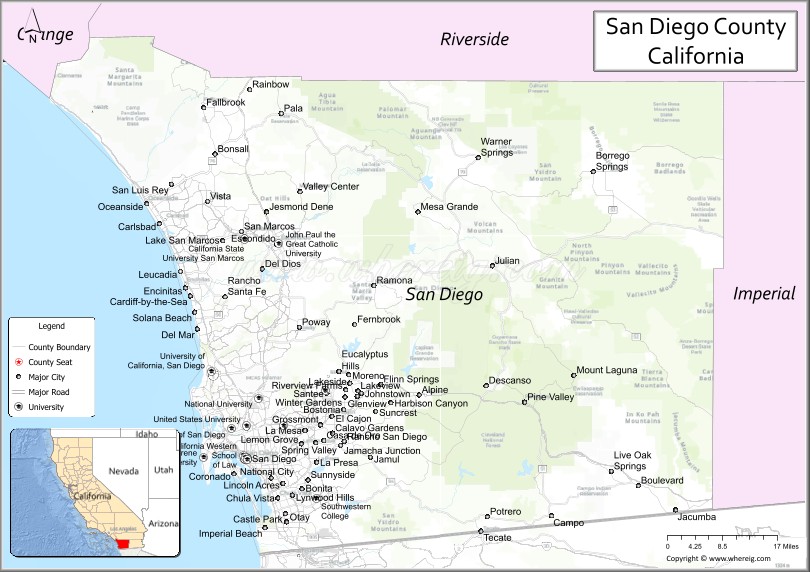
About San Diego County Map, California: The map showing the county boundary, county seat, major cities, highways, water bodies and neighbouring counties.
Most Viewed Links
About San Diego County, California
San Diego County is a county located in the U.S. state of California. It's county seat is San Diego. As per 2020 census, the population of San Diego County is 3286069 people and population density is square miles. According to the United States Census Bureau, the county has a total area of 4,204 sq mi (10,888 km2). San Diego County was established on 1850.
San Diego County is known for its beautiful beaches, perfect weather, and cultural attractions. Some of the popular destinations in the county include Balboa Park, the San Diego Zoo, SeaWorld San Diego, and the USS Midway Museum.
The county is also home to several military installations, including Marine Corps Air Station Miramar, Naval Base San Diego, and Naval Base Coronado. Additionally, San Diego County is home to several universities and colleges, including the University of California, San Diego, San Diego State University, and Point Loma Nazarene University.
Economically, San Diego County is driven by a mix of industries, including healthcare, tourism, biotechnology, and defense. The county is also a major international trade center, with the Port of San Diego being one of the busiest ports in the United States. The county's diverse economy has contributed to its high standard of living and low unemployment rate.
Facts about San Diego County, California
| Country | United States |
| State | California |
| Region | Southern California |
| County Seat | San Diego |
| Named After | San Diego de Alcalá |
| Established | 1850 |
| Organized | 1850 |
| Coordinates | 32.7157° N, 117.1611° W |
| Total Area | 4,526 sq mi |
| Land Area | 4,206 sq mi |
| Water Area | 320 sq mi |
| Population (2020) | 3,298,634 |
| Population Rank | Second most populous county in California |
| Major Cities | San Diego, Chula Vista, Oceanside, Escondido |
| Main Industries | Defense, Biotechnology, Tourism, Healthcare, International Trade |
| Major Airports | San Diego International Airport, McClellan–Palomar Airport |
| Time Zone | Pacific Time (UTC−08:00) |
| Known For | Beaches, Mild climate, Military bases, Biotechnology industry, U.S.–Mexico border region |
| Website | https://www.sandiegocounty.gov |
Ctities and Towns in San Diego County
| City Name | Type | Population (2020) | Pop. Density | Area | Incorporated |
|---|---|---|---|---|---|
| Carlsbad | City | 114,746 | 3,038.0/sq mi (1,173.0/km2) | 37.77 sq mi (97.8 km2) | July 16, 1952 |
| Chula Vista | City | 275,487 | 5,549.7/sq mi (2,142.8/km2) | 49.64 sq mi (128.6 km2) | November 28, 1911 |
| Coronado | City | 20,192 | 2,585.4/sq mi (998.2/km2) | 7.81 sq mi (20.2 km2) | December 11, 1890 |
| Del Mar | City | 3,954 | 2,298.8/sq mi (887.6/km2) | 1.72 sq mi (4.5 km2) | July 15, 1959 |
| El Cajon | City | 106,215 | 7,320.1/sq mi (2,826.3/km2) | 14.51 sq mi (37.6 km2) | November 12, 1912 |
| Encinitas | City | 62,007 | 3,253.3/sq mi (1,256.1/km2) | 19.06 sq mi (49.4 km2) | October 1, 1986 |
| Escondido | City | 151,038 | 4,043.9/sq mi (1,561.3/km2) | 37.35 sq mi (96.7 km2) | October 8, 1888 |
| Imperial Beach | City | 26,137 | 6,092.5/sq mi (2,352.3/km2) | 4.29 sq mi (11.1 km2) | July 18, 1956 |
| La Mesa | City | 61,121 | 6,724.0/sq mi (2,596.1/km2) | 9.09 sq mi (23.5 km2) | February 16, 1912 |
| Lemon Grove | City | 27,627 | 7,120.4/sq mi (2,749.2/km2) | 3.88 sq mi (10 km2) | July 1, 1977 |
| National City | City | 56,173 | 7,694.9/sq mi (2,971.0/km2) | 7.3 sq mi (18.9 km2) | September 17, 1887 |
| Oceanside | City | 174,068 | 4,217.8/sq mi (1,628.5/km2) | 41.27 sq mi (106.9 km2) | July 3, 1888 |
| Poway | City | 48,841 | 1,249.8/sq mi (482.5/km2) | 39.08 sq mi (101.2 km2) | December 1, 1980 |
| San Diego | City | 1,386,932 | 4,256.0/sq mi (1,643.2/km2) | 325.88 sq mi (844 km2) | March 27, 1850 |
| San Marcos | City | 94,833 | 3,893.0/sq mi (1,503.1/km2) | 24.36 sq mi (63.1 km2) | January 28, 1963 |
| Santee | City | 60,037 | 3,629.8/sq mi (1,401.5/km2) | 16.54 sq mi (42.8 km2) | December 1, 1980 |
| Solana Beach | City | 12,941 | 3,795.0/sq mi (1,465.3/km2) | 3.41 sq mi (8.8 km2) | July 1, 1986 |
| Vista | City | 98,381 | 5,247.0/sq mi (2,025.9/km2) | 18.75 sq mi (48.6 km2) | January 28, 1963 |
Places to Visit in San Diego County
Top places to visit in San Diego includes USS Midway Museum, Balboa Park, San Diego Zoo, Seaport Village, Torrey Pines State Natural, Cabrillo National Monument, San Diego Zoo Safari Park, Petco Park.
Highways in San Diego County
Interstate 5, Interstate 8, Interstate 15, Interstate 805, State Route 11, State Route 15, State Route 52, State Route 54, State Route 56, State Route 67, State Route 75, State Route 76, State Route 78, State Route 79, State Route 94, State Route 125, State Route 163, State Route 188, State Route 282, State Route 905.
Nearest Airports
Nearest airport of San Diego is San Diego (SAN) Airport.
- Alameda County Map
- Alpine County Map
- Amador County Map
- Butte County Map
- Calaveras County Map
- Colusa County Map
- Contra Costa County Map
- Del Norte County Map
- El Dorado County Map
- Fresno County Map
- Glenn County Map
- Humboldt County Map
- Imperial County Map
- Inyo County Map
- Kern County Map
- Kings County Map
- Lake County Map
- Lassen County Map
- Los Angeles County Map
- Madera County Map
- Marin County Map
- Mariposa County Map
- Mendocino County Map
- Merced County Map
- Modoc County Map
- Mono County Map
- Monterey County Map
- Napa County Map
- Nevada County Map
- Orange County Map
- Placer County Map
- Plumas County Map
- Riverside County Map
- Sacramento County Map
- San Benito County Map
- San Bernardino County Map
- San Diego County Map
- San Francisco County Map
- San Joaquin County Map
- San Luis Obispo County Map
- San Mateo County Map
- Santa Barbara County Map
- Santa Clara County Map
- Santa Cruz County Map
- Shasta County Map
- Sierra County Map
- Siskiyou County Map
- Solano County Map
- Sonoma County Map
- Stanislaus County Map
- Sutter County Map
- Tehama County Map
- Trinity County Map
- Tulare County Map
- Tuolumne County Map
- Ventura County Map
- Yolo County Map
- Yuba County Map
- Alabama Counties
- Alaska boroughs
- Arizona Counties
- Arkansas Counties
- California County Map
- Colorado Counties
- Connecticut Counties
- Delaware Counties
- Florida County Map
- Georgia County Map
- Hawaii Counties
- Idaho Counties
- Illinois Counties
- Indiana Counties
- Iowa Counties
- Kansas Counties
- Kentucky Counties
- Louisiana Counties
- Maine Counties
- Maryland Counties
- Massachusetts Counties
- Michigan County Map
- Minnesota Counties
- Mississippi Counties
- Missouri Counties
- Montana Counties
- Nebraska Counties
- New Hampshire Counties
- New Jersey Counties
- New Mexico Counties
- North Carolina Counties
- North Dakota Counties
- Oklahoma Counties
- Oregon Counties
- Pennsylvania Counties
- Rhode Island Counties
- South Carolina Counties
- South Dakota Counties
- Map of Tennessee
- Texas County Map
- Utah Counties
- Vermont Counties
- Virginia Counties
- Washington Counties
- West Virginia Counties
- Wisconsin Counties
- Wyoming Counties
- Nevada Counties
- New York Counties
- Ohio County Map