Written and fact-checked by Whereig.com Web Team | Last Updated: December 16, 2025, 14:30 ET
Map of Lake County - Lake County is a county located in the U.S. state of California. Lake County Map showing cities, highways, important places and water bodies. Get Where is Lake County located in the map, major cities in Lake county, population, areas, and places of interest.
Lake County Map, California
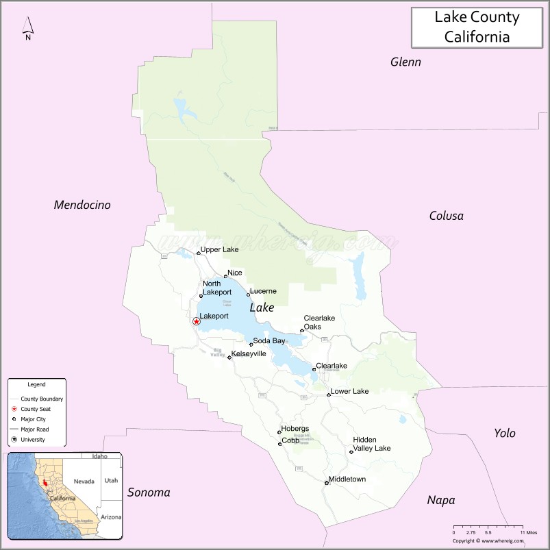
About Lake County Map, California: The map showing the county boundary, county seat, major cities, highways, water bodies and neighbouring counties.
Most Viewed Links
About Lake County, California
Lake County is a county located in the northern part of the state of California in the United States. Its county seat is Lakeport. The county is known for its natural beauty, including Clear Lake, the largest natural freshwater lake in the state of California, and the surrounding mountains and vineyards.
Lake County has a population of approximately 64,000 people and covers an area of about 1,330 square miles. The county is home to a number of wineries and is known for its production of wine grapes. Outdoor recreational activities such as fishing, boating, hiking, and camping are popular in the area.Lake County was established on 1861.
Lakeport is the largest community in Lake County and serves as the county seat. Other communities in the county include Clearlake, Kelseyville, and Upper Lake.
Facts about Lake County, California
| Country | United States |
| State | California |
| Region | Northern California (Clear Lake region) |
| County Seat | Lakeport |
| Named After | Clear Lake |
| Established | 1861 |
| Organized | 1861 |
| Coordinates | 39.0996° N, 122.7530° W |
| Total Area | 1,329 sq mi |
| Land Area | 1,258 sq mi |
| Water Area | 71 sq mi |
| Population (2020) | 68,163 |
| Population Rank | Small-to-mid-sized county in California |
| Major Cities | Lakeport, Clearlake |
| Main Industries | Agriculture, Wine Production, Tourism, Government Services |
| Major Airport | Lampson Field (Lake County Airport) |
| Time Zone | Pacific Time (UTC−08:00) |
| Known For | Clear Lake, Wine country, Outdoor recreation, Volcanic landscapes |
| Website | https://www.lakecountyca.gov |
Ctities and Towns in Lake County County
| City Name | Type | Population (2020) | Pop. Density | Area | Incorporated |
|---|---|---|---|---|---|
| Clearlake | City | 16,685 | 1,647.1/sq mi (635.9/km2) | 10.13 sq mi (26.2 km2) | November 14, 1980 |
| Lakeport | City | 5,026 | 1,642.5/sq mi (634.2/km2) | 3.06 sq mi (7.9 km2) | April 30, 1888 |
Places to Visit in Lake County County
Top places to visit in Lake includes Redwood National and, Lava Beds National, Sacramento River Bend Area, Battle Creek, Coleman National Fish, Shasta Lake, Lake Almanor, Whiskeytown Lake, .
Highways in Lake County
State Route 20, State Route 29, State Route 53, State Route 175, State Route 281.
Nearest Airports
Nearest airport of Lake is Lampson Field.
- Alameda County Map
- Alpine County Map
- Amador County Map
- Butte County Map
- Calaveras County Map
- Colusa County Map
- Contra Costa County Map
- Del Norte County Map
- El Dorado County Map
- Fresno County Map
- Glenn County Map
- Humboldt County Map
- Imperial County Map
- Inyo County Map
- Kern County Map
- Kings County Map
- Lake County Map
- Lassen County Map
- Los Angeles County Map
- Madera County Map
- Marin County Map
- Mariposa County Map
- Mendocino County Map
- Merced County Map
- Modoc County Map
- Mono County Map
- Monterey County Map
- Napa County Map
- Nevada County Map
- Orange County Map
- Placer County Map
- Plumas County Map
- Riverside County Map
- Sacramento County Map
- San Benito County Map
- San Bernardino County Map
- San Diego County Map
- San Francisco County Map
- San Joaquin County Map
- San Luis Obispo County Map
- San Mateo County Map
- Santa Barbara County Map
- Santa Clara County Map
- Santa Cruz County Map
- Shasta County Map
- Sierra County Map
- Siskiyou County Map
- Solano County Map
- Sonoma County Map
- Stanislaus County Map
- Sutter County Map
- Tehama County Map
- Trinity County Map
- Tulare County Map
- Tuolumne County Map
- Ventura County Map
- Yolo County Map
- Yuba County Map
- Alabama Counties
- Alaska boroughs
- Arizona Counties
- Arkansas Counties
- California County Map
- Colorado Counties
- Connecticut Counties
- Delaware Counties
- Florida County Map
- Georgia County Map
- Hawaii Counties
- Idaho Counties
- Illinois Counties
- Indiana Counties
- Iowa Counties
- Kansas Counties
- Kentucky Counties
- Louisiana Counties
- Maine Counties
- Maryland Counties
- Massachusetts Counties
- Michigan County Map
- Minnesota Counties
- Mississippi Counties
- Missouri Counties
- Montana Counties
- Nebraska Counties
- Nevada Counties
- New York Counties
- New Hampshire Counties
- New Jersey Counties
- New Mexico Counties
- North Carolina Counties
- North Dakota Counties
- Ohio County Map
- Oklahoma Counties
- Oregon Counties
- Pennsylvania Counties
- Rhode Island Counties
- South Carolina Counties
- South Dakota Counties
- Map of Tennessee
- Texas County Map
- Utah Counties
- Vermont Counties
- Virginia Counties
- Washington Counties
- West Virginia Counties
- Wisconsin Counties
- Wyoming Counties