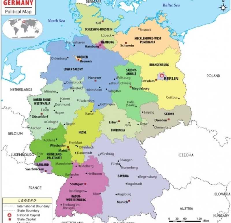
Federal Republic of Germany has 16 sovereign states. Berlin, Hamburg and Bremen are the 3 city-states in Germany. Bremen is the smallest and Bavaria is the largest federal state of Germany, it comprises 70,550 square kilometers.
Germany States and Capitals Map

This is list of Germany states and capitals by population. Germany is a country located in the Western Europe. It is bordered by Austria, Belgium, Czech Republic, Denmark, France, Luxembourg, Netherlands, Poland, Switzerland, the North Sea, and the Baltic Sea. Berlin is the capital and largest city of Germany. It is also a state-city.
List of Germany States and Capitals
| State | Capital | Population (2020) | Area (km2) | Since |
|---|---|---|---|---|
| Baden-Württemberg | Stuttgart | 11,100,394 | 35,752 | 1952 |
| Bavaria (Bayern) | Munich (München) | 13,124,737 | 70,552 | 1949 |
| Berlin | Berlin | 3,669,491 | 892 | 1990 |
| Brandenburg | Potsdam | 2,521,893 | 29,479 | 1990 |
| Bremen | Bremen | 681,202 | 419 | 1949 |
| Hamburg | Hamburg | 1,847,253 | 755 | 1949 |
| Hesse (Hessen) | Wiesbaden | 6,288,080 | 21,115 | 1949 |
| Lower Saxony (Niedersachsen) | Hanover (Hannover) | 7,993,448 | 47,609 | 1949 |
| Mecklenburg-Western Pomerania (Mecklenburg-Vorpommern) | Schwerin | 1,609,675 | 23,180 | 1990 |
| North Rhine-Westphalia (Nordrhein-Westfalen) | Düsseldorf | 17,932,651 | 34,085 | 1949 |
| Rhineland-Palatinate (Rheinland-Pfalz) | Mainz | 4,084,844 | 19,853 | 1949 |
| Saarland | Saarbrücken | 990,509 | 2,569 | 1957 |
| Saxony (Sachsen) | Dresden | 4,077,937 | 18,416 | 1990 |
| Saxony-Anhalt (Sachsen-Anhalt) | Magdeburg | 2,208,321 | 20,446 | 1990 |
| Schleswig-Holstein | Kiel | 2,896,712 | 15,799 | 1949 |
| Thuringia (Thüringen) | Erfurt | 2,143,145 | 16,172 | 1990 |
- Where is Germany
- Cities in Germany
- Germany States and Capitals
- Where is Berlin
- Where is Frankfurt
- Where is Munich
- Where is Aachen
- Where is Augsburg
- Where is Bergisch Gladbach
- Where is Bielefeld
- Where is Bochum
- Where is Bonn
- Where is Bottrop
- Where is Braunschweig
- Where is Bremen
- Where is Bremerhaven
- Where is Chemnitz
- Where is Cottbus
- Where is Darmstadt
- Where is Dortmund
- Where is Dresden
- Where is Duisburg
- Where is Duren
- Where is Dusseldorf
- Where is Erfurt
- Where is Erlangen
- Where is Essen
- Where is Esslingen
- Where is Flensburg
- Where is Freiburg
- Where is Furth
- Where is Gelsenkirchen Alt
- Where is Gera
- Where is Gottingen
- Where is Gutersloh
- Where is Hagen
- Where is Halle
- Where is Halle Neustadt
- Where is Hamburg
- Where is Hamm
- Where is Hanau Am Main
- Where is Heidelberg
- Where is Mainz
- Where is Regensburg
- Where is Heilbronn
- Where is Mannheim
- Where is Remscheid
- Where is Herne
- Where is Marl
- Where is Reutlingen
- Where is Hildesheim
- Where is Minden
- Where is Rostock
- Where is Ingolstadt
- Where is Moers
- Where is Saarbrucken
- Where is Iserlohn
- Where is Monchengladbach
- Where is Schwerin
- Where is Jena
- Where is Muenchen
- Where is Siegen
- Where is Kaiserslautern
- Where is Mulheim An Der Ruhr
- Where is Solingen
- Where is Karlsruhe
- Where is Munster
- Where is Stuttgart
- Where is Kassel
- Where is Neuss
- Where is Trier
- Where is Kiel
- Where is Neustadt
- Where is Tubingen
- Where is Koblenz
- Where is Nuernberg
- Where is Ulm
- Where is Koeln
- Where is Oberhausen
- Where is Velbert
- Where is Krefeld
- Where is Offenbach
- Where is Wiesbaden
- Where is Leipzig
- Where is Oldenburg
- Where is Wilhelmshaven
- Where is Leverkusen
- Where is Osnabruck
- Where is Witten
- Where is Lubeck
- Where is Paderborn
- Where is Wolfsburg
- Where is Ludwigsburg
- Where is Pforzheim
- Where is Wuppertal
- Where is Ludwigshafen Am Rhein
- Where is Potsdam
- Where is Wurzburg
- Where is Lunen
- Where is Ratingen
- Where is Zwickau
- Where is Magdeburg
- Where is Recklinghausen
- Where is Hannover
