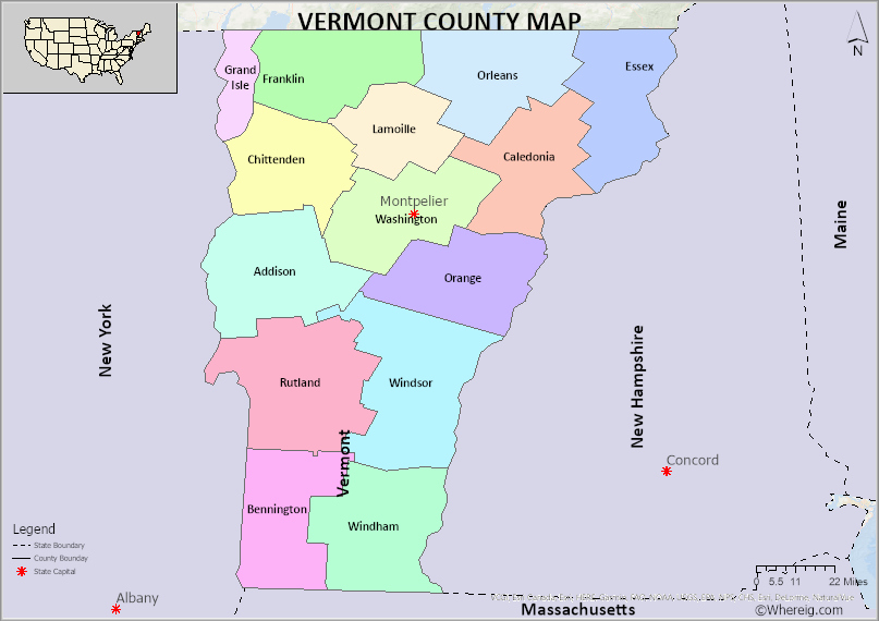
The U.S. state of Vermont is divided into 14 Counties. Explore the Vermont County Map, all Counties list along with their County Seats in alphabetical order and their population, areas and the date of formation.
Vermont County Map
 About Vermont County Map: The map showing the county boundary, all counties boundary, state capital and neighbouring states.
About Counties of Vermont
U.S State of Vermont is one of the fifty states, which is located in the New England region of the country. The state is the sixth tiniest state by geographical area. Vermont is the second least populated state United States. The state is bordered with Massachusetts to the south, New Hampshire is located in the east, New York bordered the state in the west, and Quebec which is a Canadian province located in the north. The capital city of Vermont is Montpelier.
Counties of Vermont are 14 in number. These counties are further divided into 255 political divisions. There are 237 towns, 9 cities, 5 unincorporated areas. One of the Counties of Vermont namely Chittenden County has the highest population with 168,323. The other counties of Vermont, Rutland and Washington stand as second and third in position in terms of population. Of all the Counties of Vermont Essex County is the tiniest county which is positioned in the north-eastern region of the state. Windsor County is the biggest county geographically with 969.34 square miles. Rutland county stands in second position, Windham County third in position both have occupied the state with 929.82 square miles and 785.30 square miles respectively.
U.S state of Vermont is governed by the supreme law of the land which is nothing but the constitution of the state. The constitution is guiding source of the government. According to the constitution of the state the duties are divided and vested upon legislative, executive and judicial branches. The local governance consists of incorporated municipalities. These incorporated municipalities include cities, towns and villages of the state. Counties of Vermont provide a wide range of services to the citizens of the state. All the services provided by counties are funded by the state. The services like a road network, old age homes and other infrastructure do not fall under the domain of Counties of Vermont and the governance.
The U.S. state of Vermont has 14 Counties. This is list of Vermont Counties and County Seats in alphabetical order along with check their population, areas and the date of formation.
List of Counties in Vermont with County Seats
| S.N | County | County Seat | Population | Area | Formed |
|---|---|---|---|---|---|
| 1 | Addison County | Middlebury | 37,035 | 770 sq mi | 1785 |
| 2 | Bennington County | Bennington and Manchester | 36,317 | 676 sq mi | 1779 |
| 3 | Caledonia County | St. Johnsbury | 30,780 | 651 sq mi | 1792 |
| 4 | Chittenden County | Burlington | 161,382 | 539 sq mi | 1787 |
| 5 | Essex County | Guildhall | 6,163 | 665 sq mi | 1792 |
| 6 | Franklin County | St. Albans (city) | 48,799 | 637 sq mi | 1792 |
| 7 | Grand Isle County | North Hero | 6,861 | 83 sq mi | 1802 |
| 8 | Lamoille County | Hyde Park (town) | 25,235 | 461 sq mi | 1835 |
| 9 | Orange County | Chelsea | 28,899 | 689 sq mi | 1781 |
| 10 | Orleans County | Newport (city) | 27,100 | 697 sq mi | 1792 |
| 11 | Rutland County | Rutland (city) | 59,736 | 932 sq mi | 1781 |
| 12 | Washington County | Montpelier | 58,612 | 690 sq mi | 1810 |
| 13 | Windham County | Newfane | 43,386 | 789 sq mi | 1779 |
| 14 | Windsor County | Woodstock | 55,737 | 971 sq mi | 1781 |
- Alabama Counties
- Alaska boroughs
- Arizona Counties
- Arkansas Counties
- California County Map
- Colorado Counties
- Connecticut Counties
- Delaware Counties
- Florida County Map
- Georgia County Map
- Hawaii Counties
- Idaho Counties
- Illinois Counties
- Indiana Counties
- Iowa Counties
- Kansas Counties
- Kentucky Counties
- Louisiana Counties
- Maine Counties
- Maryland Counties
- Massachusetts Counties
- Michigan County Map
- Minnesota Counties
- Mississippi Counties
- Missouri Counties
- Montana Counties
- Nebraska Counties
- New Hampshire Counties
- New Jersey Counties
- New Mexico Counties
- North Carolina Counties
- North Dakota Counties
- Oklahoma Counties
- Oregon Counties
- Pennsylvania Counties
- Rhode Island Counties
- South Carolina Counties
- South Dakota Counties
- Map of Tennessee
- Texas County Map
- Utah Counties
- Vermont Counties
- Virginia Counties
- Washington Counties
- West Virginia Counties
- Wisconsin Counties
- Wyoming Counties
- Nevada Counties
- New York Counties
- Ohio County Map
