Map of Bennington County - Bennington County is a county located in the U.S. state of Vermont. Bennington County Map showing cities, highways, important places and water bodies. Get Where is Bennington County located in the map, major cities in Bennington county, population, areas, and places of interest.
Map of Bennington County, Vermont
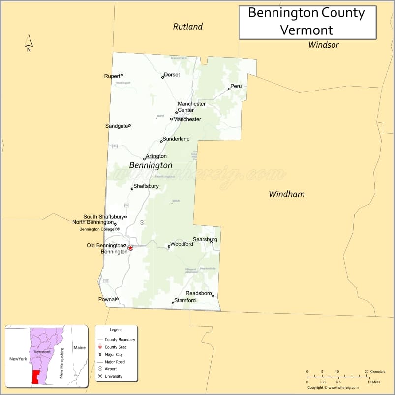
About Bennington County Map, Alabama: The map showing the county boundary, county seat, major cities, highways, water bodies and neighbouring counties.
Most Viewed Links
Map of Bennington County, Vermont
Sussex County is a county located in the U.S. state of Virginia. It`s county seat is Sussex. As per 2020 census, the population of Sussex County was 10763 and population density of Sussex was square miles. According to the United States Census Bureau, the county has a total area of 491 sq mi (1,272 km2). Sussex County was established on 1754.
Bennington County Facts
| Continent | North America |
| Country | United States |
| State | Vermont |
| County Seat | Bennington |
| Largest City/Town | Bennington |
| Established | 1778 |
| Total Area | 678 sq mi (1,756 sq km) |
| Land Area | 675 sq mi (1,748 sq km) |
| Water Area | 3 sq mi (8 sq km) |
| Population | 37,347 (Census 2020) |
| Population Density | 55.3 people per sq mi |
| Time Zone | Eastern Time Zone (ET) |
| Major Highways | U.S. Route 7, VT Route 9, VT Route 7A, VT Route 30, VT Route 67 |
| Major Rivers | Walloomsac River, Hoosic River, Batten Kill |
| Neighboring Counties | Rutland County, Windham County, Washington County (NY), Rensselaer County (NY), Berkshire County (MA) |
| Famous For | Bennington Battle Monument, Green Mountains, covered bridges, skiing, and historic villages |
| Top Attractions | Bennington Battle Monument, Hildene, Mount Equinox, Bromley Mountain, Robert Frost Stone House Museum |
| Official Website | Official Website |
About Bennington County, Vermont
Bennington County is located in the southwestern part of Vermont and was established in 1778. The county seat is Bennington, which is also the largest town in the county. The area is known for its mountain scenery, historic sites, covered bridges, and outdoor recreation opportunities in the Green Mountains region.
Cities and Towns in Bennington County, Vermont
| City/Town | Population (Census 2020) | Latitude & Longitude |
|---|---|---|
| Bennington (county seat) | 15,333 | 42.8781°N, 73.1968°W |
| Manchester | 4,484 | 43.1637°N, 73.0723°W |
| Arlington | 2,457 | 43.0748°N, 73.1540°W |
| Dorset | 2,249 | 43.2545°N, 73.0987°W |
| Pownal | 3,527 | 42.7656°N, 73.2354°W |
| Shaftsbury | 3,590 | 42.9617°N, 73.2179°W |
| Sunderland | 1,081 | 43.1017°N, 73.1181°W |
| Readsboro | 763 | 42.7779°N, 72.9640°W |
| Rupert | 714 | 43.2592°N, 73.2237°W |
| Sandgate | 405 | 43.1726°N, 73.2918°W |
| Stamford | 849 | 42.7487°N, 73.0673°W |
| Winhall | 769 | 43.1731°N, 72.9248°W |
| Woodford | 424 | 42.8873°N, 73.0679°W |
| North Bennington | 1,716 | 42.9301°N, 73.2337°W |
| Old Bennington (CDP) | 156 | 42.8914°N, 73.2051°W |
| Manchester Center (CDP) | 2,120 | 43.1770°N, 73.0556°W |
| Arlington (CDP) | 915 | 43.0742°N, 73.1547°W |
| Dorset (CDP) | 344 | 43.2542°N, 73.0991°W |
| Manchester Village (CDP) | 749 | 43.1635°N, 73.0715°W |
Best Golf Courses in Bennington County, Vermont
| Golf Course | Location | Latitude & Longitude |
|---|---|---|
| Mount Anthony Country Club | Bennington | 42.8997°N, 73.1846°W |
| Ekwanok Country Club | Manchester | 43.1709°N, 73.0501°W |
| Stratton Mountain Golf Course | Winhall | 43.1138°N, 72.9062°W |
| The Equinox Golf Resort and Spa | Manchester | 43.1639°N, 73.0697°W |
| Haystack Golf Club | Wilmington | 42.8862°N, 72.8745°W |
What are Major Roads and Highways in Bennington County
Major highways connect the county to nearby regions and cities.
- U.S. Route 7 - north-south highway connecting Bennington with Rutland and Massachusetts
- VT Route 9 - east-west route connecting Bennington with Brattleboro and New York
- VT Route 7A - scenic local route through Arlington and Manchester
- VT Route 30 - connects Dorset and nearby Rutland County towns
- VT Route 67 - links Bennington with North Bennington and New York State
Neighboring Counties of Bennington County
- Rutland County (north)
- Windham County (east)
- Washington County, New York (west)
- Rensselaer County, New York (southwest)
- Berkshire County, Massachusetts (south)
What are Top Attractions in Bennington County, Vermont
The county offers a mix of natural and cultural attractions.
| Main Sight Name | City | Famous For |
|---|---|---|
| Bennington Battle Monument | Bennington | Historic Revolutionary War monument and observation tower |
| Hildene | Manchester | Historic Lincoln family estate and gardens |
| Mount Equinox | Manchester | Mountain drives and panoramic Green Mountain views |
| Bromley Mountain | Peru | Skiing, hiking, and summer adventure park |
| Robert Frost Stone House Museum | Shaftsbury | Home and museum dedicated to poet Robert Frost |
| Equinox Preservation Trust Trails | Manchester | Hiking trails and forest landscapes |
| Lake Shaftsbury State Park | Shaftsbury | Swimming, camping, and boating |
| Old First Church | Bennington | Historic church and burial site of Robert Frost |
| Covered Bridges of Bennington County | Various Locations | Historic wooden bridges and scenic drives |
| Bennington Museum | Bennington | Regional art and history collections |
| Prospect Mountain | Woodford | Scenic mountain recreation area |
| Appalachian Trail | Sunderland | Long-distance hiking route through mountain forests |
Distance from Bennington County to Nearby Cities
The following distances are measured by road (driving).
- Bennington to Rutland (Rutland County), Vermont - 55 mi (89 km)
- Bennington to Burlington (Chittenden County), Vermont - 153 mi (246 km)
- Bennington to Manchester (Bennington County), Vermont - 23 mi (37 km)
- Bennington to Brattleboro (Windham County), Vermont - 40 mi (64 km)
- Bennington to Albany, New York - 42 mi (68 km)
- Bennington to Troy, New York - 32 mi (51 km)
- Bennington to Pittsfield, Massachusetts - 38 mi (61 km)
- Bennington to Springfield, Massachusetts - 92 mi (148 km)
- Bennington to Saratoga Springs, New York - 63 mi (101 km)
- Bennington to Montpelier (Washington County), Vermont - 128 mi (206 km)
- Bennington to North Adams, Massachusetts - 18 mi (29 km)
- Bennington to Manchester Center (Bennington County), Vermont - 24 mi (39 km)
- Bennington to Lebanon, New Hampshire - 118 mi (190 km)
- Bennington to Glens Falls, New York - 53 mi (85 km)
References
- QuickFacts - U.S. Census Bureau
- United States Census Bureau
- United States Geological Survey (USGS)
- National Geodetic Survey
- Official County Website
- Alabama Counties
- Alaska boroughs
- Arizona Counties
- Arkansas Counties
- California County Map
- Colorado Counties
- Connecticut Counties
- Delaware Counties
- Florida County Map
- Georgia County Map
- Hawaii Counties
- Idaho Counties
- Illinois Counties
- Indiana Counties
- Iowa Counties
- Kansas Counties
- Kentucky Counties
- Louisiana Counties
- Maine Counties
- Maryland Counties
- Massachusetts Counties
- Michigan County Map
- Minnesota Counties
- Mississippi Counties
- Missouri Counties
- Montana Counties
- Nebraska Counties
- Nevada Counties
- New York Counties
- New Hampshire Counties
- New Jersey Counties
- New Mexico Counties
- North Carolina Counties
- North Dakota Counties
- Ohio County Map
- Oklahoma Counties
- Oregon Counties
- Pennsylvania Counties
- Rhode Island Counties
- South Carolina Counties
- South Dakota Counties
- Map of Tennessee
- Texas County Map
- Utah Counties
- Vermont Counties
- Virginia Counties
- Washington Counties
- West Virginia Counties
- Wisconsin Counties
- Wyoming Counties