Map of Essex County - Essex County is a county located in the U.S. state of Vermont. Essex County Map showing cities, highways, important places and water bodies. Get Where is Essex County located in the map, major cities in Essex county, population, areas, and places of interest.
Map of Essex County, Vermont
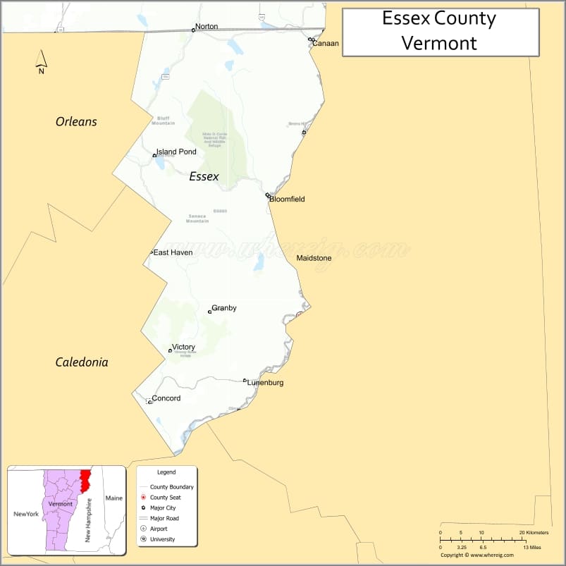
About Essex County Map, Alabama: The map showing the county boundary, county seat, major cities, highways, water bodies and neighbouring counties.
Most Viewed Links
Map of Essex County, Vermont
Washington County is a county located in the U.S. state of Virginia. It`s county seat is Abingdon. As per 2020 census, the population of Washington County was 53635 and population density of Washington was square miles. According to the United States Census Bureau, the county has a total area of 564 sq mi (1,461 km2). Washington County was established on 1777.
Essex County Facts
| Continent | North America |
| Country | United States |
| State | Vermont |
| County Seat | Guildhall |
| Largest City/Town | Brighton |
| Established | 1792 |
| Total Area | 675 sq mi (1,748 sq km) |
| Land Area | 664 sq mi (1,720 sq km) |
| Water Area | 11 sq mi (28 sq km) |
| Population | 5,920 (Census 2020) |
| Population Density | 8.9 people per sq mi |
| Time Zone | Eastern Time Zone (ET) |
| Major Highways | U.S. Route 2, VT Route 102, VT Route 114, VT Route 105, VT Route 111 |
| Major Rivers | Connecticut River, Clyde River, Nulhegan River |
| Neighboring Counties | Orleans County, Caledonia County, Coos County (NH), Grafton County (NH), Carroll County (NH) |
| Famous For | Northeast Kingdom wilderness, moose sightings, lakes, forests, and snowmobiling |
| Top Attractions | Island Pond, Silvio O. Conte National Wildlife Refuge, Brighton State Park, Maidstone Lake, Victory Basin |
| Official Website | Official Website |
About Essex County, Vermont
Essex County is located in the northeastern corner of Vermont and was established in 1792. The county seat is Guildhall, while Brighton is the largest town in the county. Essex County is the least populated county in Vermont and is known for its remote forests, mountain landscapes, lakes, and outdoor recreation opportunities in the Northeast Kingdom.
Cities and Towns in Essex County, Vermont
| City/Town | Population (Census 2020) | Latitude & Longitude |
|---|---|---|
| Brighton | 1,274 | 44.8081°N, 71.8857°W |
| Guildhall (county seat) | 262 | 44.4448°N, 71.7354°W |
| Concord | 1,141 | 44.4289°N, 71.8884°W |
| Lunenburg | 1,246 | 44.4684°N, 71.6948°W |
| Canaan | 896 | 44.9978°N, 71.5337°W |
| Bloomfield | 222 | 44.7779°N, 71.6415°W |
| Brunswick | 95 | 44.7062°N, 71.6579°W |
| East Haven | 259 | 44.6431°N, 71.8037°W |
| Ferdinand | 33 | 44.7601°N, 71.7262°W |
| Granby | 88 | 44.5615°N, 71.7004°W |
| Lemington | 93 | 44.8867°N, 71.5598°W |
| Maidstone | 218 | 44.6551°N, 71.5820°W |
| Norton | 169 | 45.0098°N, 71.7992°W |
| Victory | 70 | 44.5118°N, 71.8404°W |
| Island Pond (CDP) | 811 | 44.8145°N, 71.8848°W |
| North Concord (CDP) | 110 | 44.5057°N, 71.7912°W |
| West Stewartstown (CDP) | 386 | 44.9901°N, 71.5453°W |
Best Golf Courses in Essex County, Vermont
| Golf Course | Location | Latitude & Longitude |
|---|---|---|
| Colebrook Country Club | Canaan | 44.9955°N, 71.5318°W |
| Orleans Country Club | Nearby Orleans County | 44.8067°N, 72.2031°W |
| Lancaster Country Club | Nearby Lancaster, NH | 44.4951°N, 71.5920°W |
What are Major Roads and Highways in Essex County
Major highways connect the county to nearby regions and cities.
- U.S. Route 2 - east-west highway connecting Lunenburg with St. Johnsbury and New Hampshire
- VT Route 102 - scenic route following the Connecticut River along the New Hampshire border
- VT Route 114 - connects Island Pond with Burke and Norton
- VT Route 105 - northern Vermont route linking Bloomfield and Canaan
- VT Route 111 - local route serving Brighton and surrounding communities
Neighboring Counties of Essex County
- Orleans County (northwest)
- Caledonia County (southwest)
- Coos County, New Hampshire (east)
- Grafton County, New Hampshire (southeast)
- Carroll County, New Hampshire (south)
What are Top Attractions in Essex County, Vermont
The county offers a mix of natural and cultural attractions.
| Main Sight Name | City | Famous For |
|---|---|---|
| Island Pond | Brighton | Scenic lake village and snowmobile destination |
| Brighton State Park | Brighton | Camping, boating, and hiking near Spectacle Pond |
| Silvio O. Conte National Wildlife Refuge | Nulhegan Basin | Wildlife viewing and wetland conservation |
| Maidstone Lake | Maidstone | Fishing, boating, and lakeside recreation |
| Victory Basin Wildlife Management Area | Victory | Remote forest wilderness and wildlife habitat |
| Monadnock Mountain | Lemington | Hiking and panoramic mountain views |
| Lake Wallace | Canaan | Quiet lake recreation and fishing |
| Wenlock Wildlife Management Area | Ferdinand | Birdwatching and backcountry recreation |
| Connecticut River Byway | Guildhall | Scenic driving route along the Vermont-New Hampshire border |
| Nulhegan River | Bloomfield | Kayaking, fishing, and natural scenery |
| Moose Alley Trails | Brighton | Snowmobiling and ATV trail network |
| Granby Notch | Granby | Forest landscapes and scenic mountain drives |
Distance from Essex County to Nearby Cities
The following distances are measured by road (driving).
- Guildhall to St. Johnsbury (Caledonia County), Vermont - 37 mi (60 km)
- Guildhall to Newport (Orleans County), Vermont - 52 mi (84 km)
- Guildhall to Lancaster, New Hampshire - 12 mi (19 km)
- Guildhall to Littleton, New Hampshire - 24 mi (39 km)
- Guildhall to Burlington (Chittenden County), Vermont - 128 mi (206 km)
- Guildhall to Montpelier (Washington County), Vermont - 82 mi (132 km)
- Guildhall to Barre (Washington County), Vermont - 76 mi (122 km)
- Guildhall to Concord, New Hampshire - 122 mi (196 km)
- Guildhall to Sherbrooke, Quebec - 78 mi (126 km)
- Guildhall to Berlin, New Hampshire - 44 mi (71 km)
- Guildhall to Lyndonville (Caledonia County), Vermont - 28 mi (45 km)
- Guildhall to Colebrook, New Hampshire - 18 mi (29 km)
- Guildhall to Middlebury (Addison County), Vermont - 141 mi (227 km)
- Guildhall to White River Junction (Windsor County), Vermont - 95 mi (153 km)
References
- QuickFacts - U.S. Census Bureau
- United States Census Bureau
- United States Geological Survey (USGS)
- National Geodetic Survey
- Official County Website
- Alabama Counties
- Alaska boroughs
- Arizona Counties
- Arkansas Counties
- California County Map
- Colorado Counties
- Connecticut Counties
- Delaware Counties
- Florida County Map
- Georgia County Map
- Hawaii Counties
- Idaho Counties
- Illinois Counties
- Indiana Counties
- Iowa Counties
- Kansas Counties
- Kentucky Counties
- Louisiana Counties
- Maine Counties
- Maryland Counties
- Massachusetts Counties
- Michigan County Map
- Minnesota Counties
- Mississippi Counties
- Missouri Counties
- Montana Counties
- Nebraska Counties
- Nevada Counties
- New York Counties
- New Hampshire Counties
- New Jersey Counties
- New Mexico Counties
- North Carolina Counties
- North Dakota Counties
- Ohio County Map
- Oklahoma Counties
- Oregon Counties
- Pennsylvania Counties
- Rhode Island Counties
- South Carolina Counties
- South Dakota Counties
- Map of Tennessee
- Texas County Map
- Utah Counties
- Vermont Counties
- Virginia Counties
- Washington Counties
- West Virginia Counties
- Wisconsin Counties
- Wyoming Counties