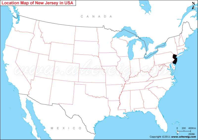
The given New Jersey location map shows that New Jersey is located on the Middle Atlantic coast of Northern-eastern United States.
Location Map of New Jersey
 About Map: Map showing location of New Jersey in the United States of America.
Other New Jersey Maps & Info
Where is New Jersey State Located?
New Jersey is a state in the Mid-Atlantic and Northeastern regions of the United States. New Jersey shares its state borders with Delaware in the south-west, Pennsylvania in the east, and New York in the north. Besides, it has coastline in the east along the Atlantic Ocean. Likewise, New Jersey lies completely within the sprawling metropolitan areas of New York City and Philadelphia. Surprisingly, New Jersey is the most densely populated state and second wealthiest state in the United States.
The capital city of New Jersey is Trenton; however, the largest city is Newark. Other important cities are Jersey City, Paterson, Elizabeth, Edison, and Woodbridge Township.
Having the humid continental climate, New Jersey is one of the most preferred tourists destinations. The state has numerous tourists’ attractions including museums, theme parks, sport centers, and entertainment centers.
New Jersey State Facts
| State Name | New Jersey |
| Country | United States |
| Continent | North America |
| Capital City | Trenton |
| Largest city | Newark |
| Largest Metro | Greater New York |
| Abbreviation | NJ, N.J. US-NJ |
| Joined the Union | December 18, 1787 (3rd) |
| Nickname | Garden State |
| Area | 8,722.58 sq mi (22,591.38 km2) |
| Timezone | Eastern: UTC -5/-4 |
| Population | 8,882,190 [11th](as of 2019) |
| Density | 1,210.10/sq mi (467/km2)[1st] |
| Highest Point | High Point |
| Lowest Point | Atlantic Ocean |
| Airport | Newark Liberty International Airport (EWR) |
| Official Website | www.nj.gov |
- Where is Akron
- Where is Anaheim
- Where is Anchorage
- Where is Arlington
- Where is Aurora
- Where is Baltimore
- Where is Baton Rouge
- Where is Birmingham
- Where is Boise City
- Where is Boston
- Where is Buffalo
- Where is Chandler
- Where is Charlotte
- Where is Chesapeake
- Where is Chula Vista
- Where is Cincinnati
- Where is Cleveland
- Where is Colorado Springs
- Where is Columbus
- Where is Corpus Christi
- Where is Des Moines
- Where is Detroit
- Where is Durham
- Where is El Paso
- Where is Fayetteville
- Where is Fort Wayne
- Where is Freemont
- Where is Fresno
- Where is Garland
- Where is Gilbert
- Where is Glendale
- Where is Greensboro
- Where is Henderson
- Where is Hialeah
- Where is Honolulu
- Where is Houston
- Where is Indianapolis
- Where is Irvine
- Where is Irving
- Where is Jacksonville
- Where is Jersey City
- Where is Kansas City
- Where is Laredo
- Where is Lincoln
- Where is Long Beach
- Where is Louisville
- Where is Lubbock
- Where is Madison
- Where is Memphis
- Where is Mesa
- Where is Milwaukee
- Where is Minneapolis
- Where is Modesto
- Where is Montgomery
- Where is Nashville
- Where is Newark
- Where is Norfolk
- Where is North Las Vegas
- Where is Oakland
- Where is Oklahoma City
- Where is Omaha
- Where is Orlando
- Where is Paradise
- Where is Philadelphia
- Where is Phoenix
- Where is Portland
- Where is Raleigh
- Where is Reno
- Where is Richmond
- Where is Riverside
- Where is Rochester
- Where is Sacramento
- Where is Saint Paul
- Where is Saint Petersburg
- Where is San Bernardino
- Where is San Jose
- Where is Santa Ana
- Where is Scottsdale
- Where is Shreveport
- Where is Spokane
- Where is St Louis
- Where is Stockton
- Where is Tampa
- Where is Toledo
- Where is Tucson
- Where is Tulsa
- Where is Virginia Beach
- Where is Wichita
