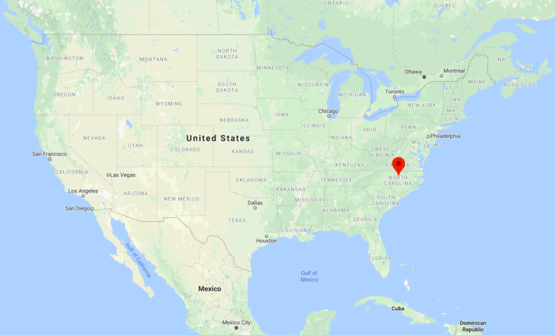
Durham is located in northern part of the North Carolina state. It is the fourth-largest city in the state of North Carolina, and 85th-largest in the country USA by population.
| Sr. No | Fact sheet | Durham |
|---|---|---|
| 1 | Country | USA |
| 2 | State | North Carolina |
| 3 | Location | Northern part of the State |
| 4 | Latitude | 35.59′19″N |
| 5 | Longitude | 78.54′26″W |
| 6 | Total area | 245.8km2 ( 95 sq mi ) |
| 7 | Total Population | 233,252 |
| 8 | Zip Codes | 27701 |
| 9 | Area code | 919, 984 |
| 10 | Nearby Cities | Cary, Raleigh, Wake Forest, Carrboro |
| 11 | Major Tourists' Attraction | Durham Castle, Lumley Castle, Finchale Priory, Durham University Botanic Garden |
| 12 | Nearest airport | Raleigh-Durham International Airport (about 15 miles) |
US Cities Location
- Where is Akron
- Where is Anaheim
- Where is Anchorage
- Where is Arlington
- Where is Aurora
- Where is Baltimore
- Where is Baton Rouge
- Where is Birmingham
- Where is Boise City
- Where is Boston
- Where is Buffalo
- Where is Chandler
- Where is Charlotte
- Where is Chesapeake
- Where is Chula Vista
- Where is Cincinnati
- Where is Cleveland
- Where is Colorado Springs
- Where is Columbus
- Where is Corpus Christi
- Where is Des Moines
- Where is Detroit
- Where is Durham
- Where is El Paso
- Where is Fayetteville
- Where is Fort Wayne
- Where is Freemont
- Where is Fresno
- Where is Garland
- Where is Gilbert
- Where is Glendale
- Where is Greensboro
- Where is Henderson
- Where is Hialeah
- Where is Honolulu
- Where is Houston
- Where is Indianapolis
- Where is Irvine
- Where is Irving
- Where is Jacksonville
- Where is Jersey City
- Where is Kansas City
- Where is Laredo
- Where is Lincoln
- Where is Long Beach
- Where is Louisville
- Where is Lubbock
- Where is Madison
- Where is Memphis
- Where is Mesa
- Where is Milwaukee
- Where is Minneapolis
- Where is Modesto
- Where is Montgomery
- Where is Nashville
- Where is Newark
- Where is Norfolk
- North Las Vegas
- Oakland
- Oklahoma City
- Where is Omaha
- Where is Orlando
- Where is Paradise
- Where is Philadelphia
- Where is Phoenix
- Where is Portland
- Where is Raleigh
- Where is Reno
- Where is Richmond
- Where is Riverside
- Where is Rochester
- Where is Sacramento
- Where is Saint Paul
- Where is Saint Petersburg
- Where is San Bernardino
- Where is San Jose
- Where is Santa Ana
- Where is Scottsdale
- Where is Shreveport
- Where is Spokane
- Where is St Louis
- Where is Stockton
- Where is Tampa
- Where is Toledo
- Where is Tucson
- Where is Tulsa
- Where is Virginia Beach
- Where is Wichita


