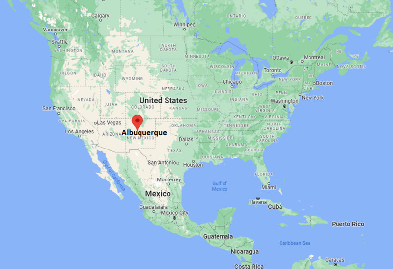
US Map showing Location Map of Albuquerque in New Mexico
Though, the city is located in the arid region of the United States but it is quite developed with having University of New Mexico, Sandia National Laboratories, Petroglyph National Monument, and Lovelace Respiratory Research Institute
The great river Rio Grande flows through the Albuquerque city in the direction of north to south and Sandia Mountains lie in the eastern side of the city. Interestingly, the architecture of the city is beautiful along with nicely designed buildings, it has also various tallest buildings in the city; for example:
Albuquerque, New Mexico Quick Facts
| Fact | Details |
|---|---|
| City | Albuquerque |
| County | Bernalillo County |
| State | New Mexico |
| State Capital | Santa Fe |
| US Region | West |
| Latitude | 35.0844° N |
| Longitude | 106.6504° W |
| Elevation | 5,312 ft (1,619 m) |
| Land Area | 187.7 sq mi |
| Water Area | 0.8 sq mi |
| Total Area | 188.5 sq mi |
| Population (2020 Census) | 564,559 |
| Population Density | Approximately 3,008 per sq mi |
| ZIP Codes | 87101, 87102, 87104, 87105, 87106, 87107, 87108, 87109, 87110, 87111, 87112, 87113, 87114, 87116, 87120, 87121, 87122, 87123, 87124, 87131, 87151, 87153, 87154, 87158, 87174, 87176, 87181, 87184, 87185, 87187, 87190, 87191, 87192, 87193, 87194, 87195, 87196, 87197, 87198, 87199 |
| Area Code | 505 |
| Time Zone Standard | Mountain Standard Time (MST, UTC-7) |
| Time Zone Daylight | Mountain Daylight Time (MDT, UTC-6) |
| Currency | US Dollar (USD) |
| FIPS Code | 35-02000 |
| Congressional District | New Mexico 1st Congressional District |
Location and Surroundings
Albuquerque is located in Bernalillo County in central New Mexico along the Rio Grande. It lies between the Sandia Mountains to the east and volcanic mesas to the west. The city is known for its Southwestern culture, technology sector, outdoor recreation, and the annual Albuquerque International Balloon Fiesta.
Nearby Cities to Albuquerque, New Mexico
- South Valley, New Mexico - 4 mi South
- North Valley, New Mexico - 5 mi North
- Los Ranchos de Albuquerque, New Mexico - 6 mi North
- Corrales, New Mexico - 11 mi Northwest
- Rio Rancho, New Mexico - 17 mi Northwest
- Bernalillo, New Mexico - 18 mi North
- Los Lunas, New Mexico - 25 mi South
- Belen, New Mexico - 36 mi South
- Santa Fe, New Mexico - 64 mi Northeast
- Socorro, New Mexico - 75 mi South
Albuquerque, New Mexico Climate and Weather Overview
| Month | Avg High (°F) | Avg Low (°F) | Avg Rainfall (in) |
|---|---|---|---|
| January | 49 | 26 | 0.5 |
| April | 69 | 41 | 0.4 |
| July | 92 | 66 | 1.5 |
| October | 73 | 45 | 0.8 |
| Annual | 71 | 46 | 9.5 |
| Climate Attribute | Details |
|---|---|
| Climate Classification (Köppen) | Cold Semi-Arid (BSk) |
| Annual Rainfall | About 9.5 inches |
| Annual Sunshine Days | Approximately 278 days |
| Hurricane/Tornado Risk | Very low hurricane risk, low tornado risk |
| Snowfall | Approximately 10 inches annually |
Driving Distances from Albuquerque, New Mexico
| City | State | Distance (mi) | Approx. Drive Time |
|---|---|---|---|
| South Valley | New Mexico | 4 | 10 min |
| North Valley | New Mexico | 5 | 10 min |
| Los Ranchos de Albuquerque | New Mexico | 6 | 15 min |
| Corrales | New Mexico | 11 | 20 min |
| Rio Rancho | New Mexico | 17 | 25 min |
| Bernalillo | New Mexico | 18 | 25 min |
| Los Lunas | New Mexico | 25 | 30 min |
| Belen | New Mexico | 36 | 40 min |
| Santa Fe | New Mexico | 64 | 1 hr |
| Socorro | New Mexico | 75 | 1 hr 15 min |
Transportation and Connectivity in Albuquerque, New Mexico
| Category | Details |
|---|---|
| Airport Name | Albuquerque International Sunport |
| IATA Code | ABQ |
| Port | Not Applicable |
| Major Highways | I-25, I-40, US 550, NM 528 |
| Train/Amtrak Service | Amtrak Southwest Chief via Albuquerque Station |
| Local Bus/Transit Service | ABQ RIDE and New Mexico Rail Runner Express |
- Interstate 25 - Major north-south corridor connecting Albuquerque with Santa Fe and Las Cruces.
- Interstate 40 - Primary east-west highway linking the city with Arizona and Texas.
- US Highway 550 - Connects Albuquerque with northwestern New Mexico communities.
- NM 528 - Serves Rio Rancho and northern metropolitan areas.
- New Mexico Rail Runner Express - Regional commuter rail connecting Albuquerque and Santa Fe.
Key Landmarks and Places to Visit in Albuquerque, New Mexico
| Landmark Name | Type |
|---|---|
| Old Town Albuquerque | Historic District |
| Sandia Peak Tramway | Scenic Attraction |
| Albuquerque International Balloon Fiesta Park | Event Venue |
| Indian Pueblo Cultural Center | Cultural Museum |
| ABQ BioPark Zoo | Zoo |
| Petroglyph National Monument | National Monument |
| National Museum of Nuclear Science & History | Museum |
| Explora Science Center | Science Museum |
| Tingley Beach | Recreation Area |
| KiMo Theatre | Historic Theater |
Waterbodies in Albuquerque, New Mexico
Rio Grande, Tingley Beach Ponds, Rio Grande Bosque, Alameda Drain, Tijeras Arroyo, Corrales Main Canal, Atrisco Drain, Isleta Drain, Cochiti Lake, Jemez River
Golf Courses in Albuquerque, New Mexico
Sandia Golf Club, UNM Championship Golf Course, Arroyo del Oso Golf Course, Ladera Golf Course, Puerto del Sol Golf Course, Isleta Eagle Golf Club, Twin Warriors Golf Club, Paako Ridge Golf Club, Paradise Hills Golf Club, Santa Ana Golf Club
Economy and Major Employers in Albuquerque, New Mexico
| Sector | Major Employer or Industry | Notes |
|---|---|---|
| Research | Sandia National Laboratories | Major scientific research and engineering employer. |
| Defense | Kirtland Air Force Base | One of the region's largest employers. |
| Healthcare | University of New Mexico Health System | Leading healthcare provider. |
| Education | University of New Mexico | Largest university in the state. |
| Technology | Technology and Aerospace Firms | Growing innovation sector. |
| Government | Federal and State Agencies | Significant public-sector employment. |
| Tourism | Hospitality and Cultural Attractions | Supports local visitor economy. |
| Manufacturing | Advanced Manufacturing Industry | Diversifies the regional economy. |
Colleges and Universities in Albuquerque, New Mexico
| Institution Name | Type | Level | Notable For |
|---|---|---|---|
| University of New Mexico | Public | University | Research and health sciences programs |
| Central New Mexico Community College | Public | Community College | Career and workforce education |
| Southwestern Indian Polytechnic Institute | Public | College | STEM education for Native students |
| National American University | Private | University | Professional and business education |
| Pima Medical Institute - Albuquerque | Private | College | Healthcare training programs |
| Brookline College - Albuquerque | Private | College | Healthcare and technical education |
Albuquerque, New Mexico - Key Historical Facts
- Albuquerque was founded in 1706 as a Spanish colonial settlement along the Rio Grande.
- The city developed as an important stop along historic trade and transportation routes in the Southwest.
- The arrival of the railroad in the nineteenth century accelerated economic growth and population expansion.
- Kirtland Air Force Base and scientific research facilities played major roles in the city's twentieth-century development.
- The Albuquerque International Balloon Fiesta began in 1972 and became one of the world's largest ballooning events.
- Today, Albuquerque is New Mexico's largest city and a major center for research, education, healthcare, and culture.
Sources
- Official City of Albuquerque Website
- Bernalillo County Official Website
- U.S. Census Bureau
- U.S. Geological Survey (USGS)
- National Weather Service
Other New Mexico Maps & Info
US Cities Location
- Where is Akron
- Where is Anaheim
- Where is Anchorage
- Where is Arlington
- Where is Aurora
- Where is Baltimore
- Where is Baton Rouge
- Where is Birmingham
- Where is Boise City
- Where is Boston
- Where is Buffalo
- Where is Chandler
- Where is Charlotte
- Where is Chesapeake
- Where is Chula Vista
- Where is Cincinnati
- Where is Cleveland
- Where is Colorado Springs
- Where is Columbus
- Where is Corpus Christi
- Where is Des Moines
- Where is Detroit
- Where is Durham
- Where is El Paso
- Where is Fayetteville
- Where is Fort Wayne
- Where is Freemont
- Where is Fresno
- Where is Garland
- Where is Gilbert
- Where is Glendale
- Where is Greensboro
- Where is Henderson
- Where is Hialeah
- Where is Honolulu
- Where is Houston
- Where is Indianapolis
- Where is Irvine
- Where is Irving
- Where is Jacksonville
- Where is Jersey City
- Where is Kansas City
- Where is Laredo
- Where is Lincoln
- Where is Long Beach
- Where is Louisville
- Where is Lubbock
- Where is Madison
- Where is Memphis
- Where is Mesa
- Where is Milwaukee
- Where is Minneapolis
- Where is Modesto
- Where is Montgomery
- Where is Nashville
- Where is Newark
- Where is Norfolk
- North Las Vegas
- Oakland
- Oklahoma City
- Where is Omaha
- Where is Orlando
- Where is Paradise
- Where is Philadelphia
- Where is Phoenix
- Where is Portland
- Where is Raleigh
- Where is Reno
- Where is Richmond
- Where is Riverside
- Where is Rochester
- Where is Sacramento
- Where is Saint Paul
- Where is Saint Petersburg
- Where is San Bernardino
- Where is San Jose
- Where is Santa Ana
- Where is Scottsdale
- Where is Shreveport
- Where is Spokane
- Where is St Louis
- Where is Stockton
- Where is Tampa
- Where is Toledo
- Where is Tucson
- Where is Tulsa
- Where is Virginia Beach
- Where is Wichita
| (adsbygoogle = window.adsbygoogle || []).push({}); |