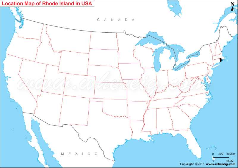
Where is Rhode Island located on the US map?
By virtue of its geographical location and having several large bays and inlets, Rhode Island is more popularly known as “The Ocean State.” Furthermore, the climate type of state is humid continental climate featured with cold winter and hot and rainy summer.
The capital City of Rhode Island is Providence; other important cities are – Warwick, Cranston, Pawtucket, East Providence, and Woonsocket.
Where is Rhode Island State Located
As shown in the given Rhode Island location map that Rhode Island is located in the north-eastern part of the United States. It is a state situated in the New England region of the United States. The small state shares its border with Connecticut in the west and Massachusetts in the north and east. It also shares maritime boundary with New York in the south-west. Rhode Island was the one of the 13th states that declared independence from the British rule and last to ratify the US Constitution.By virtue of its geographical location and having several large bays and inlets, Rhode Island is more popularly known as “The Ocean State.” Furthermore, the climate type of state is humid continental climate featured with cold winter and hot and rainy summer.
The capital City of Rhode Island is Providence; other important cities are – Warwick, Cranston, Pawtucket, East Providence, and Woonsocket.
Rhode Island State - Quick Facts
| Country: | United States |
| Region Type: | State |
| Capital: | Providence |
| Abbreviation: | RI, US-RI |
| Largest City: | Providence |
| Area: | 1,214 sq mi (3,140 km2) |
| Population: | 1,050,292 (2012 est.) |
| Joined The Union: | -40026 |
| Nickname: | The Plantation State, Little Rhody, The Ocean State |
| Highest Point: | Jerimoth Hill |
| Lowest Point: | Atlantic Ocean |
| Timezone: | Eastern: UTC −5/−4 |
| Official Website: | www.ri.gov |
More Rhode Island Maps & Info
Location Map of USA with States
- Where is Alabama (AL)
- Where is Alaska
- Where is Arizona
- Where is Arkansas Location Mapp
- Where is California
- Where is Colorado
- Where is Connecticut
- Where is Delaware
- Where is Florida
- Where is Georgia
- Where is Hawaii
- Where is Idaho State Map
- Where is Illinois
- Where is Indiana
- Where is Iowa
- Where is Kansas
- Where is Kentucky
- Where is Louisiana
- Where is Maine
- Where is Maryland
- Where is Massachusetts
- Where is Michigan
- Where is Minnesota
- Where is Mississippi
- Where is Missouri
- Where is Montana
- Where is Nebraska
- Where is Nevada
- Where is New Hampshire
- Where is New Jersey
- Where is New Mexico
- Where is New York
- Where is North Carolina
- Where is North Dakota
- Where is Ohio
- Where is Oklahoma
- Where is Oregon
- Where is Pennsylvania
- Where is Rhode Island
- Where is South Carolina
- Where is South Dakota
- Where is Tennessee
- Where is Texas
- Where is Utah
- Where is Vermont
- Where is Virginia
- Where is Washington
- Where is West Virginia
- Where is Wisconsin
- Where is Wyoming


